Difference between revisions of "2016-12-11 52 1"
imported>Sourcerer m (→Planning) |
imported>FippeBot m (Location) |
||
| (4 intermediate revisions by one other user not shown) | |||
| Line 21: | Line 21: | ||
== Expedition == | == Expedition == | ||
| + | The rain finally began to ease and it stopped for the stupidity distance, dodging low and fallen branches in the birch and pine wood. On the walk back, the moon had come out but it was still raining. No moon bow was visible though. There were minor floods on the roads and some fallen branches from high winds earlier. | ||
| + | The page history shows my image taken at 23:59 was uploaded at 2016-12-11 00:01:01. | ||
| + | |||
| + | The red track was a planned path, made earlier in the day. The blue was the actual path walked and driven. | ||
== Photos == | == Photos == | ||
<gallery caption="Photo Gallery" perrow="3"> | <gallery caption="Photo Gallery" perrow="3"> | ||
| + | Image:2016-12-11_52_1_Sourcerer_1481414327255.jpg | Arrived. [http://www.openstreetmap.org/?lat=52.29618788&lon=1.60327971&zoom=16&layers=B000FTF @52.2962,1.6033] | ||
| + | Image:2016-12-11_52_1_Sourcerer.jpg | Google Earth Track. | ||
</gallery> | </gallery> | ||
== Achievements == | == Achievements == | ||
{{#vardefine:ribbonwidth|800px}} | {{#vardefine:ribbonwidth|800px}} | ||
| + | |||
| + | {{Midnight geohash | ||
| + | | latitude = 52 | ||
| + | | longitude = 1 | ||
| + | | date = 2016-12-11 | ||
| + | | name = Sourcerer | ||
| + | }} | ||
{{Sourcerer_links | {{Sourcerer_links | ||
| Line 37: | Line 50: | ||
}} | }} | ||
| − | |||
| − | |||
[[Category:Expeditions]] | [[Category:Expeditions]] | ||
[[Category:Expeditions with photos]] | [[Category:Expeditions with photos]] | ||
[[Category:Coordinates reached]] | [[Category:Coordinates reached]] | ||
| − | + | {{location|GB|ENG|SFK}} | |
Latest revision as of 01:51, 16 August 2019
| Sun 11 Dec 2016 in Norwich, UK: 52.2963631, 1.6034981 geohashing.info google osm bing/os kml crox |
Location
Woodland in Dunwich Forest, Suffolk, UK.
Participants
Plans
Two of two spanning midnight - 2016-12-10 52 1 - 2016-12-11 52 1 - ETA 00:00.
Expedition
The rain finally began to ease and it stopped for the stupidity distance, dodging low and fallen branches in the birch and pine wood. On the walk back, the moon had come out but it was still raining. No moon bow was visible though. There were minor floods on the roads and some fallen branches from high winds earlier.
The page history shows my image taken at 23:59 was uploaded at 2016-12-11 00:01:01.
The red track was a planned path, made earlier in the day. The blue was the actual path walked and driven.
Photos
- Photo Gallery
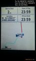
Arrived. @52.2962,1.6033
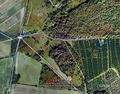
Google Earth Track.


Achievements
Sourcerer earned the Midnight Geohash achievement
|
Expeditions and Plans
| 2016-12-11 | ||
|---|---|---|
| Mannheim, Germany | DODO | On a cart course near Reilingen. |
| Norwich, United Kingdom | Sourcerer | Woodland in Dunwich Forest, Suffolk, UK. |
Sourcerer's Expedition Links
2016-12-10 52 1 - 2016-12-11 52 1 - 2016-12-12 52 1 - KML file download of Sourcerer's expeditions for use with Google Earth.