Difference between revisions of "2016-12-14 52 1"
From Geohashing
imported>Sourcerer m ([live picture] Sunset. [http://www.openstreetmap.org/?lat=52.07619309&lon=1.19560003&zoom=16&layers=B000FTF @52.0762,1.1956]) |
imported>FippeBot m (Location) |
||
| (4 intermediate revisions by one other user not shown) | |||
| Line 1: | Line 1: | ||
| − | + | {{meetup graticule | |
| − | |||
| − | |||
| − | |||
| − | |||
| − | |||
| − | |||
| − | |||
| − | |||
| − | |||
| − | {{meetup graticule | ||
| lat=52 | | lat=52 | ||
| lon=1 | | lon=1 | ||
| date=2016-12-14 | | date=2016-12-14 | ||
| + | | graticule_name=Norwich, UK | ||
| + | | graticule_link=Norwich, United Kingdom | ||
}} | }} | ||
| − | |||
| − | |||
__NOTOC__ | __NOTOC__ | ||
| + | == Location == | ||
| − | + | In a field north east of Ipswich, Suffolk, UK. | |
| − | |||
== Participants == | == Participants == | ||
| − | + | ||
| − | + | [[User:Sourcerer|Sourcerer]] | |
== Plans == | == Plans == | ||
| − | + | ||
| + | Go after walking with the Waveney Ramblers. | ||
== Expedition == | == Expedition == | ||
| − | |||
| − | + | In freak warm December sun, after walking ten miles with the Waveney Ramblers, I was already half way to the hashpoint. It was tricky finding somewhere to park in the narrow lane. The rest was easy. There was a public footpath and short bits of tractor tracks. These explain the geometrical look of my approach. I arrived at sunset. | |
| − | |||
| − | |||
| − | |||
| − | |||
| − | |||
| − | |||
| − | |||
| + | == Photos == | ||
| + | <gallery caption="Photo Gallery" perrow="3"> | ||
Image:2016-12-14_52_1_Sourcerer_1481730228667.jpg | Arrived. [http://www.openstreetmap.org/?lat=52.07618773&lon=1.19561613&zoom=16&layers=B000FTF @52.0762,1.1956] | Image:2016-12-14_52_1_Sourcerer_1481730228667.jpg | Arrived. [http://www.openstreetmap.org/?lat=52.07618773&lon=1.19561613&zoom=16&layers=B000FTF @52.0762,1.1956] | ||
| − | |||
Image:2016-12-14_52_1_Sourcerer_1481730205256.jpg | Sunset. [http://www.openstreetmap.org/?lat=52.07619309&lon=1.19560003&zoom=16&layers=B000FTF @52.0762,1.1956] | Image:2016-12-14_52_1_Sourcerer_1481730205256.jpg | Sunset. [http://www.openstreetmap.org/?lat=52.07619309&lon=1.19560003&zoom=16&layers=B000FTF @52.0762,1.1956] | ||
| + | Image:2016-12-14_52_1_Sourcerer.jpg | Google Earth Track | ||
</gallery> | </gallery> | ||
== Achievements == | == Achievements == | ||
{{#vardefine:ribbonwidth|800px}} | {{#vardefine:ribbonwidth|800px}} | ||
| − | |||
| − | + | {{Sourcerer_links | |
| − | + | | prev = 2016-12-12 52 1 | |
| − | + | | curr = 2016-12-14 52 1 | |
| + | | next = 2016-12-15 51 1 | ||
| + | | date = 2016-12-14 | ||
| + | }} | ||
| − | |||
| − | |||
| − | |||
| − | |||
| − | |||
| − | |||
| − | |||
| − | |||
| − | |||
| − | |||
[[Category:Expeditions]] | [[Category:Expeditions]] | ||
| − | |||
[[Category:Expeditions with photos]] | [[Category:Expeditions with photos]] | ||
| − | |||
| − | |||
| − | |||
| − | |||
| − | |||
[[Category:Coordinates reached]] | [[Category:Coordinates reached]] | ||
| − | + | {{location|GB|ENG|SFK}} | |
| − | |||
| − | |||
| − | |||
| − | |||
| − | |||
| − | |||
| − | |||
| − | |||
| − | |||
| − | |||
| − | |||
| − | |||
| − | |||
| − | |||
| − | |||
| − | |||
| − | |||
Latest revision as of 01:52, 16 August 2019
| Wed 14 Dec 2016 in Norwich, UK: 52.0761963, 1.1956599 geohashing.info google osm bing/os kml crox |
Location
In a field north east of Ipswich, Suffolk, UK.
Participants
Plans
Go after walking with the Waveney Ramblers.
Expedition
In freak warm December sun, after walking ten miles with the Waveney Ramblers, I was already half way to the hashpoint. It was tricky finding somewhere to park in the narrow lane. The rest was easy. There was a public footpath and short bits of tractor tracks. These explain the geometrical look of my approach. I arrived at sunset.
Photos
- Photo Gallery
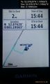
Arrived. @52.0762,1.1956
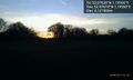
Sunset. @52.0762,1.1956
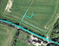
Google Earth Track


Achievements
Expeditions and Plans
| 2016-12-14 | ||
|---|---|---|
| Buffalo, New York | Pedalpusher | In an Industrial Park in Amherst just off Lawrence Bell Drive |
| Grand Rapids, Michigan | Mcbaneg | Behind the park office, Millenium Park, Grand Rapids, MI |
| Norwich, United Kingdom | Sourcerer | In a field north east of Ipswich, Suffolk, UK. |
Sourcerer's Expedition Links
2016-12-12 52 1 - 2016-12-14 52 1 - 2016-12-15 51 1 - KML file download of Sourcerer's expeditions for use with Google Earth.