Difference between revisions of "2016-12-15 51 1"
From Geohashing
imported>Sourcerer (An expedition message sent via Geohash Droid for Android.) |
imported>FippeBot m (Location) |
||
| (4 intermediate revisions by one other user not shown) | |||
| Line 1: | Line 1: | ||
| − | + | {{meetup graticule | |
| − | |||
| − | |||
| − | |||
| − | |||
| − | |||
| − | |||
| − | |||
| − | |||
| − | |||
| − | {{meetup graticule | ||
| lat=51 | | lat=51 | ||
| lon=1 | | lon=1 | ||
| date=2016-12-15 | | date=2016-12-15 | ||
| + | | graticule_name=Canterbury, UK | ||
| + | | graticule_link=Canterbury, United Kingdom | ||
}} | }} | ||
| − | |||
| − | |||
__NOTOC__ | __NOTOC__ | ||
| + | == Location == | ||
| − | + | On a farm access road and public foot path south of Great Bentley, Essex, UK. | |
| − | |||
== Participants == | == Participants == | ||
| − | + | ||
| − | + | [[User:Sourcerer|Sourcerer]] | |
== Plans == | == Plans == | ||
| − | + | ||
| + | Go after a planning meeting for the Ipswich Ramblers. | ||
== Expedition == | == Expedition == | ||
| − | |||
| − | + | This was about 30 minutes south of the meeting venue and very easily reached. It was 250 metres down a concrete farm access road and right in the middle of the track. I could have driven the car but I respected the "Farm Only" sign and walked instead. | |
| − | |||
| − | == Photos == | + | == Photos == |
| − | < | + | <gallery caption="Photo Gallery" perrow="3"> |
| − | Image: | + | Image:2016-12-15_51_1_Sourcerer_1481838791356.jpg | Arrived. [http://www.openstreetmap.org/?lat=51.84938550&lon=1.06989563&zoom=16&layers=B000FTF @51.8494,1.0699] |
| − | -- | + | Image:2016-12-15_51_1_Sourcerer.jpg | Google Earth Track |
| − | |||
</gallery> | </gallery> | ||
== Achievements == | == Achievements == | ||
{{#vardefine:ribbonwidth|800px}} | {{#vardefine:ribbonwidth|800px}} | ||
| − | |||
| − | + | {{Sourcerer_links | |
| − | + | | prev = 2016-12-14 52 1 | |
| − | + | | curr = 2016-12-15 51 1 | |
| − | + | | next = 2016-12-16 52 0 | |
| − | + | | date = 2016-12-15 | |
| − | + | }} | |
| − | |||
| − | |||
| − | |||
| − | -- | ||
| − | |||
| − | |||
| − | |||
[[Category:Expeditions]] | [[Category:Expeditions]] | ||
| − | |||
[[Category:Expeditions with photos]] | [[Category:Expeditions with photos]] | ||
| − | |||
| − | |||
| − | |||
| − | |||
| − | |||
[[Category:Coordinates reached]] | [[Category:Coordinates reached]] | ||
| − | + | {{location|GB|ENG|ESS}} | |
| − | |||
| − | |||
| − | |||
| − | |||
| − | |||
| − | |||
| − | |||
| − | |||
| − | |||
| − | |||
| − | |||
| − | |||
| − | |||
| − | |||
| − | |||
| − | |||
| − | |||
Latest revision as of 01:52, 16 August 2019
| Thu 15 Dec 2016 in Canterbury, UK: 51.8493794, 1.0698928 geohashing.info google osm bing/os kml crox |
Location
On a farm access road and public foot path south of Great Bentley, Essex, UK.
Participants
Plans
Go after a planning meeting for the Ipswich Ramblers.
Expedition
This was about 30 minutes south of the meeting venue and very easily reached. It was 250 metres down a concrete farm access road and right in the middle of the track. I could have driven the car but I respected the "Farm Only" sign and walked instead.
Photos
- Photo Gallery
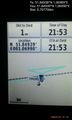
Arrived. @51.8494,1.0699
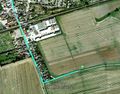
Google Earth Track


Achievements
Expeditions and Plans
| 2016-12-15 | ||
|---|---|---|
| Canterbury, United Kingdom | Sourcerer | On a farm access road and public foot path south of Great Bentley, Essex, U... |
Sourcerer's Expedition Links
2016-12-14 52 1 - 2016-12-15 51 1 - 2016-12-16 52 0 - KML file download of Sourcerer's expeditions for use with Google Earth.