Difference between revisions of "2016-12-21 52 1"
imported>Sourcerer m (→Typo) |
imported>FippeBot m (Location) |
||
| (4 intermediate revisions by one other user not shown) | |||
| Line 23: | Line 23: | ||
== Expedition == | == Expedition == | ||
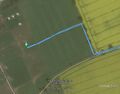
| + | On the previous expedition I was delayed six minutes by an unnecessary detour. So I arrived without additional delay. The walk to the hashpoint started on a public footpath. Then there was just under 200 metres across a ploughed field. The hashpoint was in a horse paddock under an electric fence. There were no horses so I risked electrocution and snuck in. At least I'm man enough not to squeal when I get a shock. I've been laughing at YouTube electric fence fail videos. So I've been out in the longest night of 2016. | ||
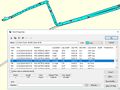
| + | I failed to get a proof screen shot at the hashpoint so I've uploaded the GPS data for 00:06. | ||
== Photos == | == Photos == | ||
<gallery caption="Photo Gallery" perrow="3"> | <gallery caption="Photo Gallery" perrow="3"> | ||
| + | Image:2016-12-21 52 1 Sourcerer.jpg | Google Earth Track | ||
| + | Image:2016-12-21 52 1 Sourcerer Proof.jpg | Garmin Mapsource Screen Shot | ||
</gallery> | </gallery> | ||
| Line 35: | Line 39: | ||
| prev = 2016-12-20 52 1 | | prev = 2016-12-20 52 1 | ||
| curr = 2016-12-21 52 1 | | curr = 2016-12-21 52 1 | ||
| − | | next = 2016-12- | + | | next = 2016-12-27 51 -0 |
| date = 2016-12-21 | | date = 2016-12-21 | ||
}} | }} | ||
| − | |||
| − | |||
[[Category:Expeditions]] | [[Category:Expeditions]] | ||
[[Category:Expeditions with photos]] | [[Category:Expeditions with photos]] | ||
[[Category:Coordinates reached]] | [[Category:Coordinates reached]] | ||
| − | + | {{location|GB|ENG|SFK}} | |
Latest revision as of 01:54, 16 August 2019
| Wed 21 Dec 2016 in Norwich, UK: 52.4477765, 1.6802649 geohashing.info google osm bing/os kml crox |
Location
A field west of Carlton Colville, Suffolk, UK.
Participants
Plans
Two of two spanning midnight - 2016-12-20 52 1 - 2016-12-21 52 1 - ETA 00:00.
Mark the winter Solstice and look forward to more daylight again.
Expedition
On the previous expedition I was delayed six minutes by an unnecessary detour. So I arrived without additional delay. The walk to the hashpoint started on a public footpath. Then there was just under 200 metres across a ploughed field. The hashpoint was in a horse paddock under an electric fence. There were no horses so I risked electrocution and snuck in. At least I'm man enough not to squeal when I get a shock. I've been laughing at YouTube electric fence fail videos. So I've been out in the longest night of 2016.
I failed to get a proof screen shot at the hashpoint so I've uploaded the GPS data for 00:06.
Photos
- Photo Gallery
Google Earth Track
Garmin Mapsource Screen Shot


Achievements
Expeditions and Plans
| 2016-12-21 | ||
|---|---|---|
| Norwich, United Kingdom | Sourcerer | A field west of Carlton Colville, Suffolk, UK. |
| Hamburg (East), Germany | GeorgDerReisende | The hash lay in an alley between two fields near Schwanheide. |
Sourcerer's Expedition Links
2016-12-20 52 1 - 2016-12-21 52 1 - 2016-12-27 51 -0 - KML file download of Sourcerer's expeditions for use with Google Earth.