Difference between revisions of "2016-12-29 52 0"
imported>Benjw (→Plans: +me) |
imported>PaintedJaguar (Coordinates reached) |
||
| Line 25: | Line 25: | ||
== Expedition == | == Expedition == | ||
| − | + | Hashpoint reached, and we've just ordered lunch in the pub. Full write-up to follow. [[User:PaintedJaguar|PaintedJaguar]] ([[User talk:PaintedJaguar|talk]]) 13:20, 29 December 2016 (UTC) | |
== Tracklog == | == Tracklog == | ||
| Line 46: | Line 46: | ||
<!-- ==REQUEST FOR TWITTER BOT== Please leave either the New report or the Expedition planning category in as long as you work on it. This helps the twitter bot a lot with announcing the right outcome at the right moment. --> | <!-- ==REQUEST FOR TWITTER BOT== Please leave either the New report or the Expedition planning category in as long as you work on it. This helps the twitter bot a lot with announcing the right outcome at the right moment. --> | ||
| − | |||
| − | |||
| − | |||
| − | |||
| − | |||
| − | |||
| − | |||
[[Category:Expeditions]] | [[Category:Expeditions]] | ||
| − | + | [[Category:Expeditions with photos]] | |
| − | [[Category:Expeditions with photos]] | ||
| − | |||
| − | |||
| − | |||
| − | |||
| − | |||
[[Category:Coordinates reached]] | [[Category:Coordinates reached]] | ||
| − | |||
| − | |||
| − | |||
| − | |||
| − | |||
| − | |||
| − | |||
| − | |||
| − | |||
| − | |||
| − | |||
| − | |||
| − | |||
| − | |||
| − | |||
| − | |||
| − | |||
| − | |||
Revision as of 13:20, 29 December 2016
| Thu 29 Dec 2016 in 52,0: 52.1366193, 0.0196567 geohashing.info google osm bing/os kml crox |
Location
The corner of a field (surrounded by public footpaths/byways) near the village of Barrington, south-west of Cambridge.
Participants
- PaintedJaguar
- MrsPaintedJaguar
Plans
PaintedJaguar and MrsPaintedJaguar plan to get the 1025 train from Ely (1055 at Cambridge) to Shepreth (arriving 1108), and then walk to the hashpoint via the public footpaths to the south-east of Shepreth Wildlife Park and then through the centre of Barrington village. We'd then head to The Royal Oak in Barrington for lunch, before returning to the train station. It's approximately 2.5 miles from the station to the hashpoint via our proposed route, so we'd probably be at the hashpoint around 12:15, and then a further 1.5 miles back to the pub, so, allowing for a bit of faffing time at the hashpoint, we'd be at the pub sometime between 13:00 and 13:15. Others are welcome to join us if they wish to work off the Christmas excesses with a short stroll, and/or then replace the excesses with a pub lunch.
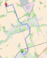
Planned walking route to hashpoint

- Just spotted this nearby hashpoint. I'll be at work tomorrow so will, with regret, decline to join you for the stroll and lunch, but I'll do my best to meet you at the hashpoint at 12:15! — Benjw {talk} 23:38, 28 December 2016 (UTC)
Expedition
Hashpoint reached, and we've just ordered lunch in the pub. Full write-up to follow. PaintedJaguar (talk) 13:20, 29 December 2016 (UTC)