Difference between revisions of "2016-12-29 52 5"
From Geohashing
imported>JwB m (→Location) |
imported>FippeBot m (Location) |
||
| (6 intermediate revisions by 2 users not shown) | |||
| Line 19: | Line 19: | ||
== Location == | == Location == | ||
| − | residential | + | residential area (near a school?) in Maarssenbroek |
== Participants == | == Participants == | ||
| Line 25: | Line 25: | ||
== Plans == | == Plans == | ||
| − | + | On my way home drive by and see how far I can get | |
== Expedition == | == Expedition == | ||
| − | + | ||
| + | Detour back from home went as planned. GPS easily guided me near, and walking up to the spot was no issue at all. Shot some photos and off I went. | ||
== Tracklog == | == Tracklog == | ||
| Line 38: | Line 39: | ||
--> | --> | ||
<gallery perrow="5"> | <gallery perrow="5"> | ||
| + | Image:Moi161229.jpg | me after a days work | ||
| + | Image:proof161229.png | on the spot | ||
| + | Image:161229a.jpg | on the sidewalk near a school. gate closed for the holidays | ||
| + | Image:161229b.jpg | and some cars parked across the street | ||
</gallery> | </gallery> | ||
== Achievements == | == Achievements == | ||
| − | |||
| − | |||
| − | |||
| − | |||
| − | |||
| − | |||
| − | |||
| − | |||
| − | |||
| − | |||
| − | |||
| − | |||
| − | |||
| − | |||
| − | |||
| − | |||
| − | |||
[[Category:Expeditions]] | [[Category:Expeditions]] | ||
| − | |||
[[Category:Expeditions with photos]] | [[Category:Expeditions with photos]] | ||
| − | |||
| − | |||
| − | |||
| − | |||
| − | |||
[[Category:Coordinates reached]] | [[Category:Coordinates reached]] | ||
| − | + | {{location|NL|UT}} | |
| − | |||
| − | |||
| − | |||
| − | |||
| − | |||
| − | |||
| − | |||
| − | |||
| − | |||
| − | |||
| − | |||
| − | |||
| − | |||
| − | |||
| − | |||
| − | |||
| − | |||
Latest revision as of 18:19, 26 July 2019
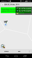
| Thu 29 Dec 2016 in 52,5: 52.1366193, 5.0196567 geohashing.info google osm bing/os kml crox |
Location
residential area (near a school?) in Maarssenbroek
Participants
Plans
On my way home drive by and see how far I can get
Expedition
Detour back from home went as planned. GPS easily guided me near, and walking up to the spot was no issue at all. Shot some photos and off I went.
Tracklog
Photos

me after a days work
on the spot
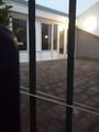
on the sidewalk near a school. gate closed for the holidays
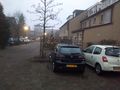
and some cars parked across the street


