Difference between revisions of "2017-01-03 55 37"
From Geohashing
imported>Dunaril ([live picture]Just before. I hit 0m on Geohash Droid but was too quick to screenshot :) [http://www.openstreetmap.org/?lat=55.90794660&lon=37.41086170&zoom=16&layers=B000FTF @55.9079,37.4109]) |
imported>FippeBot m (Location) |
||
| (9 intermediate revisions by one other user not shown) | |||
| Line 1: | Line 1: | ||
| − | |||
| − | |||
| − | |||
| − | |||
| − | |||
| − | |||
| − | |||
| − | |||
| − | |||
| − | |||
{{meetup graticule | {{meetup graticule | ||
| lat=55 | | lat=55 | ||
| Line 15: | Line 5: | ||
}} | }} | ||
| − | |||
__NOTOC__ | __NOTOC__ | ||
== Location == | == Location == | ||
| − | + | Right on a large road just out and North of Moscow, on the way to the Sheremetyevo airport. | |
== Participants == | == Participants == | ||
| − | + | [[User:Dunaril|Dunaril]] and [[User:Katu|Katu]] as irregular geohashers ; Lena and Nataliya as drivers and first time geohashers! | |
| − | |||
== Plans == | == Plans == | ||
| − | + | *Attempting a driving geohash. Google Maps indicates it to be on the other side of the road I am currently taking to the airport. It should be within the GPS uncertainty range. -- [[User:Dunaril|Dunaril]] ([[User talk:Dunaril|talk]]) [http://www.openstreetmap.org/?lat=55.86458350&lon=37.46387620&zoom=16&layers=B000FTF @55.8646,37.4639] 12:04, 3 January 2017 (GMT+03:00) | |
| + | |||
| + | We had driven the same road on our way from the airport a week earlier, so in addition to the extraordinary luck this hash also qualified for a dejà-vu achievement :) | ||
== Expedition == | == Expedition == | ||
| − | |||
| + | *We hit the geohash, according to Geohash Droid. A few pics below are all the proof I have but I definitely got into GPS uncertainty. This is completely crazy! -- [[User:Dunaril|Dunaril]] ([[User talk:Dunaril|talk]]) 12:15, 3 January 2017 (GMT+03:00) | ||
| − | + | Google Map of the GPS track: https://drive.google.com/open?id=1t9rZnrPuAzVAVgUnKXFciBkRh3A&usp=sharing | |
| − | |||
| − | |||
| − | == Photos == | + | == Photos == |
| − | |||
| − | |||
| − | |||
<gallery perrow="5"> | <gallery perrow="5"> | ||
| Line 49: | Line 34: | ||
== Achievements == | == Achievements == | ||
{{#vardefine:ribbonwidth|800px}} | {{#vardefine:ribbonwidth|800px}} | ||
| − | + | {{land geohash | |
| + | | latitude = 55 | ||
| + | | longitude = 37 | ||
| + | | date = 2017-01-03 | ||
| + | | name = [[User:Dunaril|Dunaril]] and [[User:Katu|Katu]] | ||
| + | }} | ||
| + | {{Easy_geohash | ||
| + | | latitude = 55 | ||
| + | | longitude = 37 | ||
| + | | date = 2017-01-03 | ||
| + | | name = [[User:Dunaril|Dunaril]] and [[User:Katu|Katu]] | ||
| + | }} | ||
| + | {{Déjà vu geohash | ||
| + | | latitude = 55 | ||
| + | | longitude = 37 | ||
| + | | date = 2017-01-03 | ||
| + | | olddate = 2016-12-28 | ||
| + | | name = [[User:Dunaril|Dunaril]] and [[User:Katu|Katu]] | ||
| + | }} | ||
| + | {{drag-along | ||
| + | | latitude = 55 | ||
| + | | longitude = 37 | ||
| + | | date = 2017-01-03 | ||
| + | | partner = Lena and Nataliya | ||
| + | | name = [[User:Dunaril|Dunaril]] and [[User:Katu|Katu]] | ||
| + | }} | ||
| − | |||
| − | |||
| − | |||
| − | |||
| − | |||
| − | |||
| − | |||
| − | |||
| − | |||
| − | |||
| − | |||
| − | |||
| − | |||
[[Category:Expeditions]] | [[Category:Expeditions]] | ||
| − | + | ||
| − | |||
| − | |||
| − | |||
| − | |||
| − | |||
| − | |||
[[Category:Coordinates reached]] | [[Category:Coordinates reached]] | ||
| − | + | {{location|RU|MOS}} | |
| − | |||
| − | |||
| − | |||
| − | |||
| − | |||
| − | |||
| − | |||
| − | |||
| − | |||
| − | |||
| − | |||
| − | |||
| − | |||
| − | |||
| − | |||
| − | |||
| − | |||
Latest revision as of 02:19, 7 August 2019
| Tue 3 Jan 2017 in 55,37: 55.8948450, 37.4284865 geohashing.info google osm bing/os kml crox |
Location
Right on a large road just out and North of Moscow, on the way to the Sheremetyevo airport.
Participants
Dunaril and Katu as irregular geohashers ; Lena and Nataliya as drivers and first time geohashers!
Plans
- Attempting a driving geohash. Google Maps indicates it to be on the other side of the road I am currently taking to the airport. It should be within the GPS uncertainty range. -- Dunaril (talk) @55.8646,37.4639 12:04, 3 January 2017 (GMT+03:00)
We had driven the same road on our way from the airport a week earlier, so in addition to the extraordinary luck this hash also qualified for a dejà-vu achievement :)
Expedition
- We hit the geohash, according to Geohash Droid. A few pics below are all the proof I have but I definitely got into GPS uncertainty. This is completely crazy! -- Dunaril (talk) 12:15, 3 January 2017 (GMT+03:00)
Google Map of the GPS track: https://drive.google.com/open?id=1t9rZnrPuAzVAVgUnKXFciBkRh3A&usp=sharing
Photos
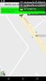
Got it! @55.8991,37.4233
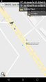
Just before. I hit 0m on Geohash Droid but was too quick to screenshot :) @55.9079,37.4109


Achievements
Dunaril and Katu earned the Land geohash achievement
|
Dunaril and Katu has visited an Easy Geohash
|
Dunaril and Katu earned the Déjà Vu Geohash Achievement
|
Dunaril and Katu earned the Drag-along achievement
|