Difference between revisions of "2017-02-08 47 11"
imported>Rincewind (→Expedition) |
m |
||
| (8 intermediate revisions by 3 users not shown) | |||
| Line 20: | Line 20: | ||
== Location == | == Location == | ||
<!-- where you've surveyed the hash to be --> | <!-- where you've surveyed the hash to be --> | ||
| + | In Zillertal, Austria, somewhere at the end of route B169 leading through the valley. Judging from the map and later, reality, right on the road. Stilluptal is a very scenic side valley of Zillertal. Absolutely beautiful in summer, not so easily accessible in winter. | ||
== Participants == | == Participants == | ||
| Line 37: | Line 38: | ||
The B169 road, however, went less and less federal in appearance, getting narrower and narrower with each village. At some point they used signs sparsely, too and we only much later realised we must be on another road just parallel- and on the other side of the small river. But it lead to the spot, anyway, so we proceeded, only to be stopped by a sign that the road is private, damaged and will not be repaired and that it's forbidden to drive there anymore. It wasn't serviced, as well, but it was less than a mile... So we decided to park and hike it. Through snow. With night closing in and being exhausted... | The B169 road, however, went less and less federal in appearance, getting narrower and narrower with each village. At some point they used signs sparsely, too and we only much later realised we must be on another road just parallel- and on the other side of the small river. But it lead to the spot, anyway, so we proceeded, only to be stopped by a sign that the road is private, damaged and will not be repaired and that it's forbidden to drive there anymore. It wasn't serviced, as well, but it was less than a mile... So we decided to park and hike it. Through snow. With night closing in and being exhausted... | ||
After a fourth of the way, we decided to abandon, because the steep climb in snow was a bit much for us. | After a fourth of the way, we decided to abandon, because the steep climb in snow was a bit much for us. | ||
| − | After stumbling back to the car, we tried to find back the B169 road, which was probably easier than losing it in the first place. Two miles on, we passed the spot, made the necessary photos | + | After stumbling back to the car, we tried to find back the B169 road, which was probably easier than losing it in the first place. Two miles on, we passed the spot, made the necessary photos, marked the spot (with non-permanent chalk marker spray) and then reversed the car for a (completely unproven) speedracer achievement. |
| − | That was not too hard or dangerous to get, since the road is limited to 30km/h. :) | + | That was not too hard or dangerous to get, since the road is limited to 30km/h at the site. :) |
If I hadn't lost directions, it would have qualified for an easy hash achievement, even. | If I hadn't lost directions, it would have qualified for an easy hash achievement, even. | ||
Made it back and now we're recovering from all our adventures. | Made it back and now we're recovering from all our adventures. | ||
| − | |||
| − | |||
| − | |||
== Photos == | == Photos == | ||
| Line 53: | Line 51: | ||
Image:2017-02-08_47_11_Rincewind_1486573994271.jpg|Successful Austria hash. :) | Image:2017-02-08_47_11_Rincewind_1486573994271.jpg|Successful Austria hash. :) | ||
| − | |||
Image:2017-02-08_47_11_Rincewind_1486574080331.jpg|XKCD was here... (Chalk paint) | Image:2017-02-08_47_11_Rincewind_1486574080331.jpg|XKCD was here... (Chalk paint) | ||
| + | Image:2017-02-08 47 11 hashdriving.jpg|Enroute to the coordinates | ||
| + | Image:2017-02-08 47 11 hashgrinII.jpg|Happy hasher, happy ninja | ||
| + | Image:2017-02-08 47 11 hashsurroundings.jpg|View from the hash... With night falling, it looked quite menacing. | ||
</gallery> | </gallery> | ||
== Achievements == | == Achievements == | ||
{{#vardefine:ribbonwidth|800px}} | {{#vardefine:ribbonwidth|800px}} | ||
| + | {{land geohash | ||
| + | |||
| + | | latitude = 47 | ||
| + | | longitude = 11 | ||
| + | | date = 2017-02-08 | ||
| + | | name = [[User:Rincewind|Rincewind]] and a dragalong-ninja | ||
| + | }} | ||
| + | {{Speed racer | ||
| + | | latitude = 47 | ||
| + | | longitude = 11 | ||
| + | | date = 2017-02-08 | ||
| + | | name = [[User:Rincewind|Rincewind]] and a dragalong-ninja | ||
| + | | speed = 30 mind-boggling kilometers per hour. | ||
| + | |||
| + | }} | ||
| + | {{drag-along | ||
| + | |latitude = 47 | ||
| + | | longitude = 11 | ||
| + | | date = 2017-02-08 | ||
| + | | partner = a ninja | ||
| + | | name = [[User:Rincewind|Rincewind]] | ||
| + | }} | ||
| + | |||
<!-- Add any achievement ribbons you earned below, or remove this section --> | <!-- Add any achievement ribbons you earned below, or remove this section --> | ||
| − | |||
| − | |||
| − | |||
| − | |||
| − | |||
| − | |||
| − | |||
| − | |||
| − | |||
| − | <!-- | + | |
| + | <!-- =============== USEFUL CATEGORIES FOLLOW ================ --> | ||
[[Category:Expeditions]] | [[Category:Expeditions]] | ||
| − | |||
[[Category:Expeditions with photos]] | [[Category:Expeditions with photos]] | ||
| − | |||
[[Category:Expedition without GPS]] | [[Category:Expedition without GPS]] | ||
| − | |||
| − | |||
| − | |||
[[Category:Coordinates reached]] | [[Category:Coordinates reached]] | ||
| − | + | <!-- or if you failed :( | |
| − | |||
| − | |||
[[Category:Coordinates not reached]] | [[Category:Coordinates not reached]] | ||
-- and a reason -- | -- and a reason -- | ||
| Line 102: | Line 110: | ||
(Don't forget to delete this final close comment marker) --> | (Don't forget to delete this final close comment marker) --> | ||
| + | {{location|AT|T|SZ}} | ||
Latest revision as of 16:05, 20 June 2020
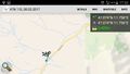
| Wed 8 Feb 2017 in 47,11: 47.0740375, 11.7563917 geohashing.info google osm bing/os kml crox |
Location
In Zillertal, Austria, somewhere at the end of route B169 leading through the valley. Judging from the map and later, reality, right on the road. Stilluptal is a very scenic side valley of Zillertal. Absolutely beautiful in summer, not so easily accessible in winter.
Participants
Rincewind (talk) and a ninja-dragalong
Plans
For the last couple of vacations here, I've more or less constantly checked coordinates, but they never seemed reachable as a side activity, or not at all. In the alps, "not reachable" is happening more often than not in winter. Yesterday I saw that the coordinates fall exactly onto a spot at the end of B169 road- which means federal road and hence, has winter service. That looked promising... It was exactly at the other side of the mountain chain where we were skiing, of course, but you can't have everything. So the plan was to simply get my first Austria hash and drag my snowboard wielding friend along.
Expedition
We've had our skiing day and where quite exhausted, but decided to go- you never know when another opportunity might present itself. The B169 road, however, went less and less federal in appearance, getting narrower and narrower with each village. At some point they used signs sparsely, too and we only much later realised we must be on another road just parallel- and on the other side of the small river. But it lead to the spot, anyway, so we proceeded, only to be stopped by a sign that the road is private, damaged and will not be repaired and that it's forbidden to drive there anymore. It wasn't serviced, as well, but it was less than a mile... So we decided to park and hike it. Through snow. With night closing in and being exhausted... After a fourth of the way, we decided to abandon, because the steep climb in snow was a bit much for us. After stumbling back to the car, we tried to find back the B169 road, which was probably easier than losing it in the first place. Two miles on, we passed the spot, made the necessary photos, marked the spot (with non-permanent chalk marker spray) and then reversed the car for a (completely unproven) speedracer achievement. That was not too hard or dangerous to get, since the road is limited to 30km/h at the site. :)
If I hadn't lost directions, it would have qualified for an easy hash achievement, even. Made it back and now we're recovering from all our adventures.
Photos
Successful Austria hash. :)
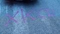
XKCD was here... (Chalk paint)
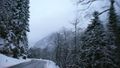
Enroute to the coordinates

Happy hasher, happy ninja
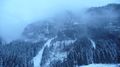
View from the hash... With night falling, it looked quite menacing.


Achievements
Rincewind and a dragalong-ninja earned the Land geohash achievement
|

Rincewind earned the Drag-along achievement
|