Difference between revisions of "2017-02-08 48 11"
imported>Solli |
imported>Solli |
||
| Line 17: | Line 17: | ||
== Expedition == | == Expedition == | ||
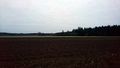
| − | + | What a convenient location: Like two weeks before I had an appointment in Haar in the evening and the Hashpoint was just a few kilometers away. So I went there after work, parked the car about 330 m away and crossed the field to reach the point. Unfortunately the field was very muddy, the kind of mud that sticks to the boots and makes walking difficult. I really should put a spare pair of mud boots into my car just in case. Anyway I reached the point at exactly 17:32, marked the spot, took a few photos and went back to the car. | |
| − | + | There were some tiny patches of snow at the location, but since the temperature was +1°C it doesn't count as a frozen geohash. | |
| − | |||
== Photos == | == Photos == | ||
| − | |||
| − | |||
| − | |||
<gallery perrow="5"> | <gallery perrow="5"> | ||
| + | 2017-02-08 48 11 Solli-01.png | Proof | ||
| + | 2017-02-08 48 11 Solli-02.jpg | Tiny patches of snow | ||
| + | 2017-02-08 48 11 Solli-03.jpg | X marks the spot | ||
| + | 2017-02-08 48 11 Solli-04.jpg | Stupid Grin (tm) in low light | ||
| + | 2017-02-08 48 11 Solli-05.jpg | View from the hash | ||
| + | 2017-02-08 48 11 Solli-06.jpg | The other direction | ||
</gallery> | </gallery> | ||
== Achievements == | == Achievements == | ||
{{#vardefine:ribbonwidth|800px}} | {{#vardefine:ribbonwidth|800px}} | ||
| − | + | {{land geohash | |
| + | | latitude = 48 | ||
| + | | longitude = 11 | ||
| + | | date = 2017-02-08 | ||
| + | | name = Solli | ||
| + | }} | ||
| − | |||
| − | |||
| − | |||
| − | |||
| − | |||
| − | |||
| − | |||
| − | |||
| − | |||
| − | |||
| − | |||
| − | |||
| − | |||
| − | |||
[[Category:Expeditions]] | [[Category:Expeditions]] | ||
| − | |||
[[Category:Expeditions with photos]] | [[Category:Expeditions with photos]] | ||
| − | |||
| − | |||
| − | |||
| − | |||
| − | |||
[[Category:Coordinates reached]] | [[Category:Coordinates reached]] | ||
| − | |||
| − | |||
| − | |||
| − | |||
| − | |||
| − | |||
| − | |||
| − | |||
| − | |||
| − | |||
| − | |||
| − | |||
| − | |||
| − | |||
| − | |||
| − | |||
| − | |||
| − | |||
Revision as of 09:10, 9 February 2017
| Wed 8 Feb 2017 in 48,11: 48.0740375, 11.7563917 geohashing.info google osm bing/os kml crox |
Location
On a field near Grasbrunn
Participants
Plans
Solli plans to be there at 17:30
Expedition
What a convenient location: Like two weeks before I had an appointment in Haar in the evening and the Hashpoint was just a few kilometers away. So I went there after work, parked the car about 330 m away and crossed the field to reach the point. Unfortunately the field was very muddy, the kind of mud that sticks to the boots and makes walking difficult. I really should put a spare pair of mud boots into my car just in case. Anyway I reached the point at exactly 17:32, marked the spot, took a few photos and went back to the car.
There were some tiny patches of snow at the location, but since the temperature was +1°C it doesn't count as a frozen geohash.
Photos
Proof
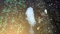
Tiny patches of snow
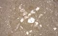
X marks the spot

Stupid Grin (tm) in low light
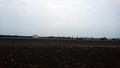
View from the hash
The other direction


Achievements
Solli earned the Land geohash achievement
|