Difference between revisions of "2017-02-10 52 1"
imported>Sourcerer (An expedition message sent via Geohash Droid for Android.) |
imported>FippeBot m (Location) |
||
| (2 intermediate revisions by one other user not shown) | |||
| Line 1: | Line 1: | ||
| − | + | {{meetup graticule | |
| − | |||
| − | |||
| − | |||
| − | |||
| − | |||
| − | |||
| − | |||
| − | |||
| − | |||
| − | {{meetup graticule | ||
| lat=52 | | lat=52 | ||
| lon=1 | | lon=1 | ||
| date=2017-02-10 | | date=2017-02-10 | ||
| + | | graticule_name=Norwich, UK | ||
| + | | graticule_link=Norwich, United Kingdom | ||
}} | }} | ||
| − | |||
| − | |||
__NOTOC__ | __NOTOC__ | ||
| + | == Location == | ||
| − | + | A meadow close to Brampton Hall, Suffolk, UK. | |
| − | |||
== Participants == | == Participants == | ||
| − | + | ||
| − | + | [[User:Sourcerer|Sourcerer]] | |
== Plans == | == Plans == | ||
| − | + | ||
| + | One of two spanning midnight [[2017-02-10 52 1]] - [[2017-02-11 52 1]] - ETA 22:45. | ||
== Expedition == | == Expedition == | ||
| − | |||
| − | == | + | Early in the month I'd caught a minor lurgy. This combined with bad weather and uninteresting points led to a slow start. Today the weather was worse and the points scarcely more interesting but I felt well. It was the full moon with a bonus partial eclipse. |
| − | + | ||
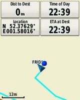
| + | *Arrived. -- [[User:Sourcerer|Sourcerer]] ([[User talk:Sourcerer|talk]]) [http://www.openstreetmap.org/?lat=52.37629473&lon=1.58016980&zoom=16&layers=B000FTF @52.3763,1.5802] 22:41, 10 February 2017 (GMT) | ||
| + | |||
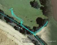
| + | There was a place to park at the start of a public footpath. A short exploration suggested this was a no go. Double fencing and a ditch were in the way. Earlier I'd spotted a gate on Google Street View. I headed back to the road and found the gate becoming overgrown. This gave access to the meadow and it was only 40 metres to the hashpoint. | ||
| − | == Photos == | + | The eclipse was a big fail. There was low cloud and continuous light rain occasionally turning to snow. There was one great bonus. An impatient driver was tailgating me even though I was driving at the speed limit plus 5%. Eventually he managed to overtake and was immediately caught by a speed camera with its distinctive camera double flash. I now have an injured hand from punching my car roof with joy! I can't repeat what I said! |
| − | < | + | |
| − | Image: | + | == Photos == |
| − | -- | + | <gallery caption="Gallery" widths="200px" heights="200px" perrow="3"> |
| − | + | Image:2017-02-10 52 1 Sourcerer.jpg | Google Earth Track | |
| + | Image:2017-02-10 52 1 Sourcerer Proof.jpg | Proof | ||
</gallery> | </gallery> | ||
== Achievements == | == Achievements == | ||
{{#vardefine:ribbonwidth|800px}} | {{#vardefine:ribbonwidth|800px}} | ||
| − | |||
| − | + | {{Sourcerer_links | |
| − | + | | prev = 2017-01-29 52 0 | |
| − | + | | curr = 2017-02-10 52 1 | |
| − | + | | next = 2017-02-11 52 1 | |
| − | + | | date = 2017-02-10 | |
| − | + | }} | |
| − | |||
| − | |||
| − | |||
| − | -- | ||
| − | |||
| − | |||
| − | |||
[[Category:Expeditions]] | [[Category:Expeditions]] | ||
| − | |||
[[Category:Expeditions with photos]] | [[Category:Expeditions with photos]] | ||
| − | |||
| − | |||
| − | |||
| − | |||
| − | |||
[[Category:Coordinates reached]] | [[Category:Coordinates reached]] | ||
| − | + | {{location|GB|ENG|SFK}} | |
| − | |||
| − | |||
| − | |||
| − | |||
| − | |||
| − | |||
| − | |||
| − | |||
| − | |||
| − | |||
| − | |||
| − | |||
| − | |||
| − | |||
| − | |||
| − | |||
| − | |||
Latest revision as of 02:07, 16 August 2019
| Fri 10 Feb 2017 in Norwich, UK: 52.3762865, 1.5801558 geohashing.info google osm bing/os kml crox |
Location
A meadow close to Brampton Hall, Suffolk, UK.
Participants
Plans
One of two spanning midnight 2017-02-10 52 1 - 2017-02-11 52 1 - ETA 22:45.
Expedition
Early in the month I'd caught a minor lurgy. This combined with bad weather and uninteresting points led to a slow start. Today the weather was worse and the points scarcely more interesting but I felt well. It was the full moon with a bonus partial eclipse.
- Arrived. -- Sourcerer (talk) @52.3763,1.5802 22:41, 10 February 2017 (GMT)
There was a place to park at the start of a public footpath. A short exploration suggested this was a no go. Double fencing and a ditch were in the way. Earlier I'd spotted a gate on Google Street View. I headed back to the road and found the gate becoming overgrown. This gave access to the meadow and it was only 40 metres to the hashpoint.
The eclipse was a big fail. There was low cloud and continuous light rain occasionally turning to snow. There was one great bonus. An impatient driver was tailgating me even though I was driving at the speed limit plus 5%. Eventually he managed to overtake and was immediately caught by a speed camera with its distinctive camera double flash. I now have an injured hand from punching my car roof with joy! I can't repeat what I said!
Photos
- Gallery
Google Earth Track
Proof


Achievements
Expeditions and Plans
| 2017-02-10 | ||
|---|---|---|
| Birmingham, United Kingdom | Pbro | In a field belonging to Hurst Farm off Crackley Lane, Kenilworth, Warwicksh... |
| Norwich, United Kingdom | Sourcerer | A meadow close to Brampton Hall, Suffolk, UK. |
Sourcerer's Expedition Links
2017-01-29 52 0 - 2017-02-10 52 1 - 2017-02-11 52 1 - KML file download of Sourcerer's expeditions for use with Google Earth.