Difference between revisions of "2017-02-26 52 1"
From Geohashing
imported>Sourcerer m (→Expedition) |
m |
||
| (2 intermediate revisions by 2 users not shown) | |||
| Line 34: | Line 34: | ||
| prev = 2017-02-13 52 1 | | prev = 2017-02-13 52 1 | ||
| curr = 2017-02-26 52 1 | | curr = 2017-02-26 52 1 | ||
| − | | next = 2017- | + | | next = 2017-03-01 52 1 |
| date = 2017-02-26 | | date = 2017-02-26 | ||
}} | }} | ||
| Line 41: | Line 41: | ||
[[Category:Expeditions with photos]] | [[Category:Expeditions with photos]] | ||
[[Category:Coordinates not reached]] | [[Category:Coordinates not reached]] | ||
| + | [[Category:Not reached - No public access]] | ||
| + | {{location|GB|ENG|SFK}} | ||
Latest revision as of 11:17, 27 March 2022
| Sun 26 Feb 2017 in Norwich, UK: 52.1715527, 1.5623797 geohashing.info google osm bing/os kml crox |
Location
A field between Snape and Aldeburgh, Suffolk, UK.
Participants
Plans
Try this after walking with the Waveney Ramblers at Tunstall forest nearby.
Expedition - Fail
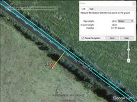
The road came within 20 metres of the hashpoint. The field was fenced and the crop was under fleece to help warm the ground. I could not reach the point with my "no damage, no disturbance" rules, so sadly, it was "Coordinates not reached".
Photos
- Gallery

Achievements
Expeditions and Plans
| 2017-02-26 | ||
|---|---|---|
| Buffalo, New York | Pedalpusher, Simon the dog, Myka the dog | In the woods of Nine Mile Creek State Forest |
| München, Germany | B2c, Micsnare | was located in a bikeshed near a housing complex in Munich, Germany. |
| Norwich, United Kingdom | Sourcerer | A field between Snape and Aldeburgh, Suffolk, UK. |
Sourcerer's Expedition Links
2017-02-13 52 1 - 2017-02-26 52 1 - 2017-03-01 52 1 - KML file download of Sourcerer's expeditions for use with Google Earth.