Difference between revisions of "2017-03-08 47 -122"
From Geohashing
imported>Thomcat ([live picture]On the spot [http://www.openstreetmap.org/?lat=47.65764560&lon=-122.27716840&zoom=16&layers=B000FTF @47.6576,-122.2772]) |
imported>FippeBot m (Location) |
||
| (7 intermediate revisions by 2 users not shown) | |||
| Line 1: | Line 1: | ||
| − | |||
| − | |||
| − | |||
| − | |||
| − | |||
| − | |||
| − | |||
| − | |||
| − | |||
| − | |||
{{meetup graticule | {{meetup graticule | ||
| lat=47 | | lat=47 | ||
| lon=-122 | | lon=-122 | ||
| date=2017-03-08 | | date=2017-03-08 | ||
| + | | graticule_name=Seattle | ||
| + | | graticule_link=Seattle, Washington | ||
}} | }} | ||
| Line 20: | Line 12: | ||
== Location == | == Location == | ||
<!-- where you've surveyed the hash to be --> | <!-- where you've surveyed the hash to be --> | ||
| + | Just off the sidewalk in a Laurelhurst street. | ||
== Participants == | == Participants == | ||
<!-- who attended: If you link to your wiki user name in this section, your expedition will be picked up by the various statistics generated for geohashing. You may use three tildes ~ as a shortcut to automatically insert the user signature of the account you are editing with. | <!-- who attended: If you link to your wiki user name in this section, your expedition will be picked up by the various statistics generated for geohashing. You may use three tildes ~ as a shortcut to automatically insert the user signature of the account you are editing with. | ||
--> | --> | ||
| + | * [[User:Zebburkeconte|Zebburkeconte]] and | ||
| + | * friend Dillon of [[2015-11-15 47 -122]] fame | ||
| + | * [[User:Thomcat|Thomcat]] | ||
== Plans == | == Plans == | ||
| Line 31: | Line 27: | ||
<!-- how it all turned out. your narrative goes here. --> | <!-- how it all turned out. your narrative goes here. --> | ||
| + | === zebburkeconte === | ||
| + | |||
| + | Finally, a walk geohash opportunity! I had taken a bus from home, but between when I saw the geohash (on campus) and reached it, it was walking-only, so I'm going to count it. Probably could have tronned it if we tried, but we didn't. | ||
| + | |||
| + | === Thomcat === | ||
| + | Great spot, but too busy to achieve it during a rainy day. Finally in the evening I carved out some time and drove southeast to where the hashpoint lay. | ||
*Here -- [[User:Thomcat|Thomcat]] ([[User talk:Thomcat|talk]]) [http://www.openstreetmap.org/?lat=47.65765280&lon=-122.27717920&zoom=16&layers=B000FTF @47.6577,-122.2772] 22:33, 8 March 2017 (PST) | *Here -- [[User:Thomcat|Thomcat]] ([[User talk:Thomcat|talk]]) [http://www.openstreetmap.org/?lat=47.65765280&lon=-122.27717920&zoom=16&layers=B000FTF @47.6577,-122.2772] 22:33, 8 March 2017 (PST) | ||
| + | |||
| + | It being dark in a residential neighborhood, I snapped a few photos and skedaddled. | ||
| + | |||
| + | |||
== Tracklog == | == Tracklog == | ||
<!-- if your GPS device keeps a log, you may post a link here --> | <!-- if your GPS device keeps a log, you may post a link here --> | ||
| Line 40: | Line 46: | ||
Image:2012-##-## ## ## Alpha.jpg | Witty Comment | Image:2012-##-## ## ## Alpha.jpg | Witty Comment | ||
--> | --> | ||
| + | |||
| + | === zebburkeconte === | ||
| + | |||
| + | <gallery perrow="5"> | ||
| + | |||
| + | Image:2017-03-08_47_-122_1.jpeg|Cheesin' | ||
| + | |||
| + | Image:2017-03-08_47_-122_2.png|Proof | ||
| + | </gallery> | ||
| + | |||
| + | === Thomcat === | ||
| + | |||
<gallery perrow="5"> | <gallery perrow="5"> | ||
Image:2017-03-08_47_-122_thomcat_1489041302242.jpg|On the spot [http://www.openstreetmap.org/?lat=47.65764560&lon=-122.27716840&zoom=16&layers=B000FTF @47.6576,-122.2772] | Image:2017-03-08_47_-122_thomcat_1489041302242.jpg|On the spot [http://www.openstreetmap.org/?lat=47.65764560&lon=-122.27716840&zoom=16&layers=B000FTF @47.6576,-122.2772] | ||
| + | |||
| + | Image:2017-03-08_47_-122_thomcat_1489041343748.jpg|Geohasher [http://www.openstreetmap.org/?lat=47.65766090&lon=-122.27716000&zoom=16&layers=B000FTF @47.6577,-122.2772] | ||
</gallery> | </gallery> | ||
| Line 49: | Line 69: | ||
<!-- Add any achievement ribbons you earned below, or remove this section --> | <!-- Add any achievement ribbons you earned below, or remove this section --> | ||
| − | + | {{Walk geohash | |
| − | + | | latitude = 47 | |
| − | + | | longitude = -122 | |
| − | + | | date = 2017-03-08 | |
| − | + | | name = Zeb & Dillon | |
| − | + | | distance = 1.7 miles | |
| − | + | }} | |
| − | |||
| − | |||
| − | |||
| − | |||
| − | |||
| − | |||
[[Category:Expeditions]] | [[Category:Expeditions]] | ||
| − | |||
[[Category:Expeditions with photos]] | [[Category:Expeditions with photos]] | ||
| − | |||
| − | |||
| − | |||
| − | |||
| − | |||
[[Category:Coordinates reached]] | [[Category:Coordinates reached]] | ||
| − | + | {{location|US|WA|KN}} | |
| − | |||
| − | |||
| − | |||
| − | |||
| − | |||
| − | |||
| − | |||
| − | |||
| − | |||
| − | |||
| − | |||
| − | |||
| − | |||
| − | |||
| − | |||
| − | |||
| − | |||
Latest revision as of 02:13, 16 August 2019
| Wed 8 Mar 2017 in Seattle: 47.6576468, -122.2771632 geohashing.info google osm bing/os kml crox |
Location
Just off the sidewalk in a Laurelhurst street.
Participants
- Zebburkeconte and
- friend Dillon of 2015-11-15 47 -122 fame
- Thomcat
Plans
Expedition
zebburkeconte
Finally, a walk geohash opportunity! I had taken a bus from home, but between when I saw the geohash (on campus) and reached it, it was walking-only, so I'm going to count it. Probably could have tronned it if we tried, but we didn't.
Thomcat
Great spot, but too busy to achieve it during a rainy day. Finally in the evening I carved out some time and drove southeast to where the hashpoint lay.
- Here -- Thomcat (talk) @47.6577,-122.2772 22:33, 8 March 2017 (PST)
It being dark in a residential neighborhood, I snapped a few photos and skedaddled.
Tracklog
Photos
zebburkeconte
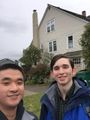
Cheesin'
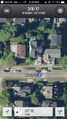
Proof


Thomcat
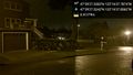
On the spot @47.6576,-122.2772

Geohasher @47.6577,-122.2772


Achievements
Zeb & Dillon earned the Walk geohash Achievement
|