Difference between revisions of "2017-03-15 52 5"
imported>JwB m (→Participants) |
imported>FippeBot m (Location) |
||
| (6 intermediate revisions by 2 users not shown) | |||
| Line 19: | Line 19: | ||
== Location == | == Location == | ||
| − | + | A field near Almere, almost no deviation from my commute needed. | |
== Participants == | == Participants == | ||
| Line 25: | Line 25: | ||
== Plans == | == Plans == | ||
| − | + | Commute with a little deviation, stop, walk up, collect proof, walk away and continue to work. Should be possible. | |
== Expedition == | == Expedition == | ||
| − | + | so it went. turned out that i could easily park along the road, and then had around 600 meter to walk into the freshly ploughed field. fortunately the clay was dry because of the beautiful spring wheather the we had for the last week. And there was a path along a ditch that was used by the tractors, so i could take that for most of the distance. Chose the correct side from depart so did not even have to jump the ditch as it turned out. just 20 meters off the path into the clay the point was, took pictures, and made my way back. nice break from the driving. | |
== Tracklog == | == Tracklog == | ||
| Line 34: | Line 34: | ||
== Photos == | == Photos == | ||
| − | |||
| − | |||
| − | |||
<gallery perrow="5"> | <gallery perrow="5"> | ||
| + | Image: path20170315.jpg | chose the correct side of the ditch | ||
| + | Image: hash20170315.jpg | now through the field | ||
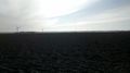
| + | Image: Me20170315.jpg | sun above horizon | ||
| + | Image: proof2017-03-15.png | there | ||
</gallery> | </gallery> | ||
== Achievements == | == Achievements == | ||
| − | |||
| − | |||
| − | |||
| − | |||
| − | |||
| − | |||
| − | |||
| − | |||
| − | |||
| − | |||
| − | |||
| − | |||
| − | |||
| − | |||
| − | |||
| − | |||
| − | |||
[[Category:Expeditions]] | [[Category:Expeditions]] | ||
| − | |||
[[Category:Expeditions with photos]] | [[Category:Expeditions with photos]] | ||
| − | |||
| − | |||
| − | |||
| − | |||
| − | |||
[[Category:Coordinates reached]] | [[Category:Coordinates reached]] | ||
| − | + | {{location|NL|FL}} | |
| − | |||
| − | |||
| − | |||
| − | |||
| − | |||
| − | |||
| − | |||
| − | |||
| − | |||
| − | |||
| − | |||
| − | |||
| − | |||
| − | |||
| − | |||
| − | |||
| − | |||
Latest revision as of 18:25, 26 July 2019
| Wed 15 Mar 2017 in 52,5: 52.3915635, 5.3954586 geohashing.info google osm bing/os kml crox |
Location
A field near Almere, almost no deviation from my commute needed.
Participants
Plans
Commute with a little deviation, stop, walk up, collect proof, walk away and continue to work. Should be possible.
Expedition
so it went. turned out that i could easily park along the road, and then had around 600 meter to walk into the freshly ploughed field. fortunately the clay was dry because of the beautiful spring wheather the we had for the last week. And there was a path along a ditch that was used by the tractors, so i could take that for most of the distance. Chose the correct side from depart so did not even have to jump the ditch as it turned out. just 20 meters off the path into the clay the point was, took pictures, and made my way back. nice break from the driving.
Tracklog
Photos
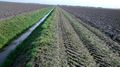
chose the correct side of the ditch
now through the field

sun above horizon
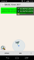
there


