Difference between revisions of "2017-04-09 31 -106"
imported>Gefrierbrand ([live] Testing the app) |
imported>FippeBot m (Location) |
||
| (3 intermediate revisions by one other user not shown) | |||
| Line 1: | Line 1: | ||
| − | |||
| − | |||
| − | |||
| − | |||
| − | |||
| − | |||
| − | |||
| − | |||
| − | |||
| − | |||
{{meetup graticule | {{meetup graticule | ||
| lat=31 | | lat=31 | ||
| Line 14: | Line 4: | ||
| date=2017-04-09 | | date=2017-04-09 | ||
}} | }} | ||
| − | |||
| − | |||
__NOTOC__ | __NOTOC__ | ||
== Location == | == Location == | ||
| − | + | Right on the edge of a parking lot near the Biggs Army Airfield inside Fort Bliss. | |
== Participants == | == Participants == | ||
| − | + | [[User:Gefrierbrand|Gefrierbrand]] | |
| − | |||
| − | |||
| − | |||
| − | |||
== Expedition == | == Expedition == | ||
| − | + | This was an awesome opportunity too good to pass up. At my now third time in the US I noticed the Hashpoint for this Sunday would finally lie in an accessible location near me – moreover one where I could get some new achievements ;) | |
| + | While I didn't know the specific location, I've been to the general area before. Fortunately, the excellent Maps from Google and the specific hash location really called for a try without GPS. I memorized which turns on which roads I would have to take and to my delight, I didn't even need the larger scale printout to get to the parking lot in question. Once stopped there, I used the roads, corners and the marked lines from each parking spot as reference and compared them to the small-scale printout, which took only a few seconds. The spot was practically unmissable. | ||
| − | + | Moreover, the place in question lies within the not publicly accessible Fort Bliss Army installation, which I just happened to have access to. | |
| − | |||
| − | |||
== Photos == | == Photos == | ||
| − | |||
| − | |||
| − | |||
<gallery perrow="5"> | <gallery perrow="5"> | ||
| + | Image:2017-04-09 31 -106map.jpg | The Map Printout I used for navigation displayed on the Hashpoint | ||
| + | Image:2017-04-09 31 -106stupidgrin.jpg | Obligatory Stupid Grin | ||
| + | Image:2017-04-09 31 -106screenshot.png | GPS verification afterwards | ||
</gallery> | </gallery> | ||
== Achievements == | == Achievements == | ||
{{#vardefine:ribbonwidth|800px}} | {{#vardefine:ribbonwidth|800px}} | ||
| − | + | {{Globetrotter6 | |
| + | | name = Gefrierbrand | ||
| + | | northamerica = true | ||
| + | | europe = true | ||
| + | | continents = 2 | ||
| + | }} | ||
| + | {{No_batteries_geohash | ||
| + | | latitude = 31 | ||
| + | | longitude = -106 | ||
| + | | date = 2017-04-09 | ||
| + | | name = Gefrierbrand | ||
| + | }} | ||
| + | {{Restricted area | ||
| + | | latitude = 31 | ||
| + | | longitude = -106 | ||
| + | | date = 2017-04-09 | ||
| + | | name = Gefrierbrand | ||
| + | | site = Fort Bliss | ||
| + | }} | ||
| − | |||
| − | |||
| − | |||
| − | |||
| − | |||
| − | |||
| − | |||
| − | |||
| − | |||
| − | |||
| − | |||
| − | |||
| − | |||
| − | |||
[[Category:Expeditions]] | [[Category:Expeditions]] | ||
| − | |||
[[Category:Expeditions with photos]] | [[Category:Expeditions with photos]] | ||
| − | |||
[[Category:Expedition without GPS]] | [[Category:Expedition without GPS]] | ||
| − | |||
| − | |||
| − | |||
[[Category:Coordinates reached]] | [[Category:Coordinates reached]] | ||
| − | + | {{location|US|TX|EP}} | |
| − | |||
| − | |||
| − | |||
| − | |||
| − | |||
| − | |||
| − | |||
| − | |||
| − | |||
| − | |||
| − | |||
| − | |||
| − | |||
| − | |||
| − | |||
| − | |||
| − | |||
Latest revision as of 02:22, 16 August 2019
| Sun 9 Apr 2017 in 31,-106: 31.8322100, -106.3737482 geohashing.info google osm bing/os kml crox |
Location
Right on the edge of a parking lot near the Biggs Army Airfield inside Fort Bliss.
Participants
Expedition
This was an awesome opportunity too good to pass up. At my now third time in the US I noticed the Hashpoint for this Sunday would finally lie in an accessible location near me – moreover one where I could get some new achievements ;)
While I didn't know the specific location, I've been to the general area before. Fortunately, the excellent Maps from Google and the specific hash location really called for a try without GPS. I memorized which turns on which roads I would have to take and to my delight, I didn't even need the larger scale printout to get to the parking lot in question. Once stopped there, I used the roads, corners and the marked lines from each parking spot as reference and compared them to the small-scale printout, which took only a few seconds. The spot was practically unmissable.
Moreover, the place in question lies within the not publicly accessible Fort Bliss Army installation, which I just happened to have access to.
Photos
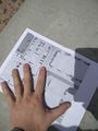
The Map Printout I used for navigation displayed on the Hashpoint

Obligatory Stupid Grin
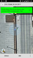
GPS verification afterwards


Achievements
Gefrierbrand earned the Globetrotter achievement
|
Gefrierbrand earned the No Batteries Geohash Achievement
|
Gefrierbrand earned the Restricted area achievement
|