Difference between revisions of "2017-04-14 48 11"
From Geohashing
imported>Solli |
imported>FippeBot m (Location) |
||
| (One intermediate revision by one other user not shown) | |||
| Line 22: | Line 22: | ||
== Photos == | == Photos == | ||
<gallery perrow="5"> | <gallery perrow="5"> | ||
| − | Image:2017-04- | + | Image:2017-04-14 48 11 Solli 01.jpg | The hashpoint |
| − | Image:2017-04- | + | Image:2017-04-14 48 11 Solli 02.png | Proof |
| − | Image:2017-04- | + | Image:2017-04-14 48 11 Solli 03.jpg | View from the hashpoint |
| − | Image:2017-04- | + | Image:2017-04-14 48 11 Solli 04.jpg | The hashfield from outside |
</gallery> | </gallery> | ||
| Line 48: | Line 48: | ||
[[Category:Expeditions with photos]] | [[Category:Expeditions with photos]] | ||
[[Category:Coordinates reached]] | [[Category:Coordinates reached]] | ||
| + | {{location|DE|BY|ED}} | ||
Latest revision as of 02:23, 16 August 2019
| Fri 14 Apr 2017 in 48,11: 48.2461103, 11.8713271 geohashing.info google osm bing/os kml crox |
Location
On a field near Hofsingelding, east of Munich
Participants
Plans
Not much of a plan: Go there, see if it's reachable and take some photos
Expedition
The hashpoint was close to our stable, but not close enough to ride there (I'm not a very experienced rider). So I went there by car and walked the last 200m to the field. As it turned out the hash field was the only one where nothing was planted yet, so I could go there without destroying any seeds.
Photos
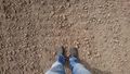
The hashpoint
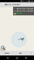
Proof
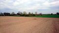
View from the hashpoint
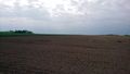
The hashfield from outside


Achievements
Solli earned the Land geohash achievement
|
This user earned the Consecutive geohash achievement
|