Difference between revisions of "2017-06-21 48 11"
imported>Claralucia9 (→Photos) |
m (Username changed) |
||
| (4 intermediate revisions by 3 users not shown) | |||
| Line 23: | Line 23: | ||
== Participants == | == Participants == | ||
| − | + | [[User:Clearlucid9|Claralucia9]] ([[User talk:Clearlucid9|talk]]) | |
| − | |||
| − | Claralucia9 | ||
== Plans == | == Plans == | ||
| Line 35: | Line 33: | ||
A happy ending for a long day at work .-) | A happy ending for a long day at work .-) | ||
| − | *Claralucia9 @ 17.40 -- [[User: | + | *Claralucia9 @ 17.40 -- [[User:Clearlucid9|Claralucia9]] ([[User talk:Clearlucid9|talk]]) 17:49, 21 June 2017 (GMT+02:00) |
== Tracklog == | == Tracklog == | ||
| Line 54: | Line 52: | ||
{{#vardefine:ribbonwidth|800px}} | {{#vardefine:ribbonwidth|800px}} | ||
<!-- Add any achievement ribbons you earned below, or remove this section --> | <!-- Add any achievement ribbons you earned below, or remove this section --> | ||
| + | {{land geohash | latitude = 48 | longitude = 11 | date = 2017-06-21 | name = Claralucia9 | ||
| + | }} | ||
| − | |||
| − | |||
| − | |||
| − | |||
| − | |||
| − | |||
| − | |||
| − | |||
| − | |||
| − | |||
| − | |||
| − | |||
| − | |||
| − | |||
[[Category:Expeditions]] | [[Category:Expeditions]] | ||
| − | |||
[[Category:Expeditions with photos]] | [[Category:Expeditions with photos]] | ||
| − | |||
| − | |||
| − | |||
| − | |||
| − | |||
[[Category:Coordinates reached]] | [[Category:Coordinates reached]] | ||
| − | + | {{location|DE|BY|M|city=true}} | |
| − | |||
| − | |||
| − | |||
| − | |||
| − | |||
| − | |||
| − | |||
| − | |||
| − | |||
| − | |||
| − | |||
| − | |||
| − | |||
| − | |||
| − | |||
| − | |||
| − | |||
Latest revision as of 12:33, 31 October 2021
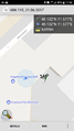
| Wed 21 Jun 2017 in 48,11: 48.1319419, 11.5768751 geohashing.info google osm bing/os kml crox |
Location
in Munich city, very close to Gärtnerplatz, in the courtyard of a building
Participants
Plans
Expedition
As I started my way home from work I had a quick look for today's hash coordinate, expecting them to be far away as so often. But surprise, surprise: inner city Munich and only a short detour from my way home. So I changed my way accordingly and headed for the hash location. As the map indicated that I was located in the courtyard of a building I did not expect to get to the exact coordinates. But approaching the spot I found the gate open as there appears to be a business back there. So I walked in and took my pics. Unfortunately the GPS is not very accurate in the city and close to high buildings, but I actually stood on the spot indicated on the map. A happy ending for a long day at work .-)
- Claralucia9 @ 17.40 -- Claralucia9 (talk) 17:49, 21 June 2017 (GMT+02:00)
Tracklog
Photos
GPS

me on the spot
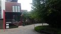
view from the hash
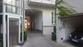
view from the hash 2


Achievements
Claralucia9 earned the Land geohash achievement
|