Difference between revisions of "2017-07-18 51 9"
From Geohashing
imported>GeorgDerReisende (new report) |
imported>GeorgDerReisende (expedition report for Großalmerode) |
||
| Line 1: | Line 1: | ||
| + | [[Image:{{{image|2017-07-18 51 9 GeorgDerReisende 8050.jpg}}}|thumb|left]] | ||
| − | |||
| − | |||
| − | |||
| − | |||
| − | |||
| − | |||
| − | |||
| − | |||
| − | |||
{{meetup graticule | {{meetup graticule | ||
| lat=51 | | lat=51 | ||
| Line 19: | Line 11: | ||
== Location == | == Location == | ||
| − | + | ||
| + | Some meters beyond a forest path, east of Großalmerode. | ||
== Participants == | == Participants == | ||
| − | + | ||
| − | + | [[User:GeorgDerReisende|GeorgDerReisende]] | |
== Plans == | == Plans == | ||
| − | + | ||
| + | Go! | ||
== Expedition == | == Expedition == | ||
| − | |||
| − | + | A long time ago I walked this forest way (to [[2014-09-08 51 9]]) and I didn't have a look to this wonderful place. But today I made it. But at first I found out, that the hash was ten meters away from the way down on a steep slope. But it looked like an older forest way down there, like a terrace, and I walked around and got a one meter shot. I didn't want to dance at that place for a better one. | |
| − | |||
== Photos == | == Photos == | ||
| Line 39: | Line 31: | ||
--> | --> | ||
<gallery perrow="5"> | <gallery perrow="5"> | ||
| + | Image:2017-07-18 51 9 GeorgDerReisende 8049.jpg | down there | ||
| + | Image:2017-07-18 51 9 GeorgDerReisende 8055.jpg | the right way | ||
| + | Image:2017-07-18 51 9 GeorgDerReisende 8058.jpg | proof | ||
| + | Image:2017-07-18 51 9 GeorgDerReisende 8059.jpg | look to the north, up to the new forest way | ||
| + | Image:2017-07-18 51 9 GeorgDerReisende 8060.jpg | the west | ||
| + | Image:2017-07-18 51 9 GeorgDerReisende 8061.jpg | the east | ||
| + | Image:2017-07-18 51 9 GeorgDerReisende 8062.jpg | the south | ||
| + | Image:2017-07-18 51 9 GeorgDerReisende 8064.jpg | the geohasher | ||
</gallery> | </gallery> | ||
| Line 45: | Line 45: | ||
<!-- Add any achievement ribbons you earned below, or remove this section --> | <!-- Add any achievement ribbons you earned below, or remove this section --> | ||
| − | + | {{Easy_geohash | latitude = 51 | longitude = 9 | date = 2017-07-18 | name = GeorgDerReisende }} | |
| − | |||
| − | |||
| − | |||
| − | |||
| − | |||
| − | |||
| − | |||
| − | |||
| − | |||
| − | |||
| − | |||
| − | |||
[[Category:Expeditions]] | [[Category:Expeditions]] | ||
| − | |||
[[Category:Expeditions with photos]] | [[Category:Expeditions with photos]] | ||
| − | + | ||
| − | |||
| − | |||
| − | |||
| − | |||
[[Category:Coordinates reached]] | [[Category:Coordinates reached]] | ||
| − | |||
| − | |||
| − | |||
| − | |||
| − | |||
| − | |||
| − | |||
| − | |||
| − | |||
| − | |||
| − | |||
| − | |||
| − | |||
| − | |||
| − | |||
| − | |||
| − | |||
| − | |||
Revision as of 15:53, 18 July 2017

| Tue 18 Jul 2017 in 51,9: 51.2588917, 9.8138236 geohashing.info google osm bing/os kml crox |
Location
Some meters beyond a forest path, east of Großalmerode.
Participants
Plans
Go!
Expedition
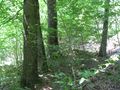
A long time ago I walked this forest way (to 2014-09-08 51 9) and I didn't have a look to this wonderful place. But today I made it. But at first I found out, that the hash was ten meters away from the way down on a steep slope. But it looked like an older forest way down there, like a terrace, and I walked around and got a one meter shot. I didn't want to dance at that place for a better one.
Photos
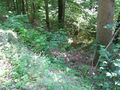
down there
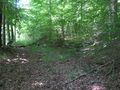
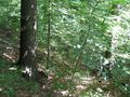
the right way
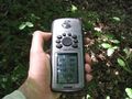
proof
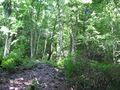
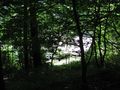
look to the north, up to the new forest way
the west
the east
the south
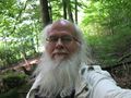
the geohasher


Achievements
GeorgDerReisende has visited an Easy Geohash
|