Difference between revisions of "2017-07-29 41 -71"
imported>Vbob (→Location) |
m (Replacing http://wiki.xkcd.com/geohashing/2013-04-24_41_-71 with 2013-04-24 41 -71) |
||
| (17 intermediate revisions by 3 users not shown) | |||
| Line 15: | Line 15: | ||
}} | }} | ||
| − | + | ||
__NOTOC__ | __NOTOC__ | ||
== Location == | == Location == | ||
| − | |||
Around back of the Exeter-West Greenwich Regional High School - again. | Around back of the Exeter-West Greenwich Regional High School - again. | ||
| + | |||
| + | Less than 200' from an earlier geohash we achieved. | ||
== Participants == | == Participants == | ||
| − | + | ||
| − | |||
* [[User:Vbob|Vbob]] and | * [[User:Vbob|Vbob]] and | ||
* Bruce | * Bruce | ||
== Plans == | == Plans == | ||
| − | + | ||
| + | Realized on Friday morning that this Saturday hash was going to be a glorious sunny day [I was wrong]; and that the hash was in an interesting public place where the opportunities for Drag-Along and/or already-happened-to-be-here were good [ I was half wrong]; so trying to organize a long-overdue meet up was worthwhile.... | ||
| + | |||
| + | * Except I'd forgotten my wiki password; | ||
| + | * Except that the wiki engine wouldn't send me a reset email; | ||
| + | * Even though it let me create a new account and new password; It wouldn't send the new me an email to authorize us to create an expedition page..... | ||
| + | |||
| + | So the word didn't get out, and the raw weather kept the [almost] interested bystanders at home; so partner and I went anyway.... | ||
== Expedition == | == Expedition == | ||
| − | |||
| − | + | Drove there after a lobster lunch with in-laws, outlaws and grandsons. Expected to find some random student | |
| − | + | athletes using the fields behind the school, but we didn't see another soul. Did the geohash dance under the | |
| + | trees, and found the hash to land in the middle of a picnic table. We were hoping it would be somewhere on | ||
| + | the flagstones of a small amphitheater, the center of which is marked with a very nice compass rose, but | ||
| + | that was about 100' off the hash. | ||
| + | |||
== Photos == | == Photos == | ||
| − | + | ||
| − | |||
| − | |||
<gallery perrow="5"> | <gallery perrow="5"> | ||
| + | Image:2017.07.29_41_-71_hash_by_iPhone.jpg | iPhone pins us at the hash | ||
| + | Image:2017.07.29_41_-71_Vbob_n'_Bruce_grin.jpg | the Grin™ x 2 | ||
| + | Image:2017.07.29_41_-71_picnic_table_long shot.jpg | a nice bit of [virtual] hash dead center on the picnic table | ||
| + | Image:2017.07.29_41_-71_compass_rose_1.jpg | even though this would have been a perfect spot for a hash | ||
| + | Image:2017.07.29_41_-71_back_of_high_school.jpg | high school complex | ||
</gallery> | </gallery> | ||
== Achievements == | == Achievements == | ||
{{#vardefine:ribbonwidth|800px}} | {{#vardefine:ribbonwidth|800px}} | ||
| − | + | ||
| − | + | {{Land geohash | |
| − | + | | latitude = 41 | |
| − | + | | longitude = -71 | |
| − | + | | date = 2017-07-29 | |
| − | + | | name = [[User:Vbob|Vbob]] n' Bruce | |
| − | + | }} | |
| − | + | ||
| − | |||
| − | |||
| − | |||
| − | |||
| − | |||
| − | |||
| − | |||
| − | |||
| − | |||
| − | |||
| − | [[ | ||
| − | |||
| − | |||
| − | |||
| − | |||
| − | |||
| − | |||
| − | |||
| − | |||
| − | |||
| − | |||
| − | |||
| − | |||
| − | |||
| − | |||
{{Déjà vu geohash | {{Déjà vu geohash | ||
| latitude = 41 | | latitude = 41 | ||
| longitude = -71 | | longitude = -71 | ||
| date = 2017-07-29 | | date = 2017-07-29 | ||
| − | | | + | | olddate = 2013-04-24 |
| − | | name = [[Vbob]] n' Bruce | + | | name = [[User:Vbob|Vbob]] n' Bruce |
}} | }} | ||
| − | + | [[2013-04-24 41 -71]] | |
| − | + | ||
| + | 2013 hash 41.6062521, -71.6377289 | ||
| + | |||
| + | 2017 hash 41.6067425, -71.6376951 | ||
| + | |||
| + | difference = 0.0004904 N, -0.0000338 E | ||
| + | |||
| + | or about 179' N and 12' E of earlier hash | ||
| + | |||
| + | [[Category:Expeditions]] | ||
| + | [[Category:Coordinates reached]] | ||
| + | [[Category:Expeditions with photos]] | ||
| + | {{location|US|RI|KE}} | ||
Latest revision as of 09:55, 19 February 2020
| Sat 29 Jul 2017 in 41,-71: 41.6067425, -71.6376951 geohashing.info google osm bing/os kml crox |
Location
Around back of the Exeter-West Greenwich Regional High School - again.
Less than 200' from an earlier geohash we achieved.
Participants
- Vbob and
- Bruce
Plans
Realized on Friday morning that this Saturday hash was going to be a glorious sunny day [I was wrong]; and that the hash was in an interesting public place where the opportunities for Drag-Along and/or already-happened-to-be-here were good [ I was half wrong]; so trying to organize a long-overdue meet up was worthwhile....
- Except I'd forgotten my wiki password;
- Except that the wiki engine wouldn't send me a reset email;
- Even though it let me create a new account and new password; It wouldn't send the new me an email to authorize us to create an expedition page.....
So the word didn't get out, and the raw weather kept the [almost] interested bystanders at home; so partner and I went anyway....
Expedition
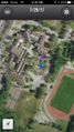
Drove there after a lobster lunch with in-laws, outlaws and grandsons. Expected to find some random student athletes using the fields behind the school, but we didn't see another soul. Did the geohash dance under the trees, and found the hash to land in the middle of a picnic table. We were hoping it would be somewhere on the flagstones of a small amphitheater, the center of which is marked with a very nice compass rose, but that was about 100' off the hash.
Photos
iPhone pins us at the hash
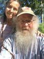
the Grin™ x 2
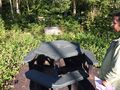
a nice bit of [virtual] hash dead center on the picnic table
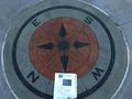
even though this would have been a perfect spot for a hash
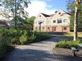
high school complex


Achievements
Vbob n' Bruce earned the Land geohash achievement
|
Vbob n' Bruce earned the Déjà Vu Geohash Achievement
|
2013 hash 41.6062521, -71.6377289
2017 hash 41.6067425, -71.6376951
difference = 0.0004904 N, -0.0000338 E
or about 179' N and 12' E of earlier hash