Difference between revisions of "2017-07-31 52 0"
imported>PaintedJaguar (Create expedition page) |
imported>FippeBot m (Location) |
||
| (5 intermediate revisions by one other user not shown) | |||
| Line 1: | Line 1: | ||
| − | |||
| − | |||
| − | |||
| − | |||
| − | |||
| − | |||
| − | |||
| − | |||
| − | |||
| − | |||
| − | |||
| − | |||
{{meetup graticule | {{meetup graticule | ||
| lat=52 | | lat=52 | ||
| Line 17: | Line 5: | ||
}} | }} | ||
| − | |||
__NOTOC__ | __NOTOC__ | ||
== Location == | == Location == | ||
| − | + | On a public footpath just off Dunstan Street in Ely, and just over 350m from [[User:PaintedJaguar|PaintedJaguar]]'s house as the crow flies, making him eligible for a Couch Potato honourable mention (walking distance approximately 550m). | |
== Participants == | == Participants == | ||
| − | + | * [[User:PaintedJaguar|PaintedJaguar]] | |
| − | |||
== Plans == | == Plans == | ||
| − | + | This is the first hashpoint in Ely that PaintedJaguar has noticed since moving to Ely approximately a year ago. It's sufficiently close to his house, and at the other side of the weekend, that, at the time of writing (Friday 28th July) there are no specific plans. A midnight geohash is tempting, but we'll see what happens on the day. | |
== Expedition == | == Expedition == | ||
| − | |||
| − | == | + | === Expedition 1 (midnight) === |
| − | + | I decided to aim for the first midnight of the day, on Sunday night/Monday morning. I was sitting at home at 23:45 and suddenly realised that I was going to have go soon if I was going to make it. I grabbed my camera and GPS, quickly programmed in the co-ordinates, and set off, on foot. Reaching the estate containing the geohash was no problem at all, and I arrived with 4 minutes to spare before midnight. The footpath where the geohash was located was a path off the corner of a road, heading towards a playing field, and went along the front of a row of houses. Clearly the ideal place to be hanging around for a few minutes, on your own, with a camera, at midnight! | |
| + | |||
| + | As I walked along the path, I noticed that one house had a bewildering array of LEDs and/or other lights in its upstairs window, one of which was quite definitely red when I first saw it but turned green as I approached. I was absolutely convinced that this whole setup was mounted on something which turned to follow me as I went. My already low level of paranoia as to the situation I was in suddenly increased markedly as I became convinced that somebody inside one of the houses was monitoring and recording my every move via some hi-tec, possibly home-brew, motion detection security camera system. Doubtless I was being paranoid about nothing, and I fully intend to return after work on Monday evening, in daylight, to see exactly what the collection of LEDs actually is, but it's fair to say that I was definitely uncomfortable. | ||
| + | |||
| + | Of course, I then had to walk backwards and forwards a few times in order to zero in on the hash, which I really didn't want to have to have do, given the situation I was in. As I finally zeroed in on the hashpoint, it turned out that it was right outside the only house with lights on its front window and doorway, which again, I really didn't want. I was also still in view of the multi-LED house. My paranoia was now in overdrive! | ||
| + | |||
| + | I left a chalk marker on the path whilst waiting for midnight to tick around, and then got my camera out to take the necessary proof, and immediately discovered that it had a completely flat battery! Therefore I had to fall back to my phone camera, which really is completely useless in the dark, as you'll see from the photos. It's sadly impossible to make out the co-ordinates on the photo of my GPS, but you can see that the time is midnight. The top-right number (15 feet) is the GPS accuracy and the middle-left (13 feet) is the distance to the hashpoint. The bottom-right value of 52 feet is the elevation. The GPS tracklog is included below for extra proof. Two more incredibly bad photos were taken, one of the chalk marker I left on the path, and one of the "view" from the hashpoint, which consisted of an out-of-focus shot of a dark path with some street lights in the distance. | ||
| + | |||
| + | I went to leave the area and head home, and almost immediately heard a front door opening behind me. I didn't stop to find out who was coming out of their house! | ||
| + | |||
| + | As hinted at above, I will be returning to the hashpoint in daylight to get a better look at the surroundings, and convince myself that I had absolutely no reason whatsoever to be as paranoid as I felt whilst at the hashpoint. | ||
| + | |||
| + | === Expedition 2 (daylight) === | ||
| + | |||
| + | I returned to the hashpoint on Monday evening at approximately 7pm, in daylight. Around the corner from the hashpoint, I encountered a small black and white cat which stopped to let me stroke it, but sadly I recognised the cat as "Stitch", belonging to my next-door neighbour, thus rendering it invalid for the Hashcat achievement. | ||
| + | |||
| + | Looking along the row of houses, I was able to see that the row of LEDs belonged to a set of what I think are small solar-powered lanterns that are normally quite popular in gardens, but were instead adorning the balcony handrails. The one that I thought had turned to follow me was mounted in a hanging basket, so entirely probable that it had rotated as I walked past. It's amazing the tricks the mind can play on when you're in an unfamiliar area in the middle of the night! | ||
| + | |||
| + | My chalk marker from the previous night was still present on the floor, although my GPS claimed that the hashpoint was now five steps away from where I'd placed the marker the night before - an interesting lesson in GPS accuracy in built-up areas. | ||
| + | |||
| + | On the way home, I encountered another cat, but this one wasn't willing to come over and be stroked, so the hashcat achievement remained elusive. | ||
| + | |||
== Photos == | == Photos == | ||
| − | < | + | |
| − | Image: | + | === Expedition 1 (midnight) === |
| − | --> | + | <gallery perrow="4"> |
| − | <gallery perrow=" | + | Image:2017-07-31-52-0-gps.jpg|GPS proof (ish) |
| + | Image:2017-07-31-52-0-marker.jpg|XKCD chalk marker | ||
| + | Image:2017-07-31-52-0-view.jpg|Out-of-focus view from hashpoint | ||
| + | Image:2017-07-31-52-0-tracklog.png|Tracklog map giving better proof | ||
| + | </gallery> | ||
| + | |||
| + | === Expedition 2 (daylight) === | ||
| + | <gallery perrow="6"> | ||
| + | Image:2017-07-31-52-0-exp2-stitch.JPG|Stitch the non-hashcat | ||
| + | Image:2017-07-31-52-0-exp2-proof.JPG|GPS proof | ||
| + | Image:2017-07-31-52-0-exp2-marker.JPG|XKCD marker, still present | ||
| + | Image:2017-07-31-52-0-exp2-balcony.JPG|Balcony with lights (not multiple security cameras) | ||
| + | Image:2017-07-31-52-0-exp2-view1.JPG|View from hashpoint (same direction as last night's photo) | ||
| + | Image:2017-07-31-52-0-exp2-view2.JPG|View from hashpoint (opposite direction) | ||
</gallery> | </gallery> | ||
== Achievements == | == Achievements == | ||
{{#vardefine:ribbonwidth|800px}} | {{#vardefine:ribbonwidth|800px}} | ||
| − | |||
| − | + | {{couch potato geohash | |
| − | + | | latitude = 52 | |
| − | + | | longitude = 0 | |
| + | | date = 2017-07-31 | ||
| + | | name = PaintedJaguar | ||
| + | | honor = true | ||
| + | }} | ||
| − | + | {{Walk geohash | |
| + | | latitude = 52 | ||
| + | | longitude = 0 | ||
| + | | date = 2017-07-31 | ||
| + | | name = PaintedJaguar | ||
| + | | distance = 1.1km | ||
| + | }} | ||
| − | + | {{Midnight geohash | |
| − | + | | latitude = 52 | |
| − | + | | longitude = 0 | |
| − | + | | date = 2017-07-31 | |
| + | | name = PaintedJaguar | ||
| + | }} | ||
| + | |||
| + | {{Easy_geohash | ||
| + | | latitude = 52 | ||
| + | | longitude = 0 | ||
| + | | date = 2017-07-31 | ||
| + | | name = PaintedJaguar | ||
| + | }} | ||
| − | |||
| − | |||
[[Category:Expeditions]] | [[Category:Expeditions]] | ||
| − | |||
[[Category:Expeditions with photos]] | [[Category:Expeditions with photos]] | ||
| − | |||
| − | |||
| − | |||
| − | |||
| − | |||
[[Category:Coordinates reached]] | [[Category:Coordinates reached]] | ||
| − | + | {{location|GB|ENG|CAM}} | |
| − | |||
| − | |||
| − | |||
| − | |||
| − | |||
| − | |||
| − | |||
| − | |||
| − | |||
| − | |||
| − | |||
| − | |||
| − | |||
| − | |||
| − | |||
| − | |||
| − | |||
Latest revision as of 02:48, 16 August 2019
| Mon 31 Jul 2017 in 52,0: 52.4046955, 0.2500251 geohashing.info google osm bing/os kml crox |
Location
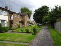
On a public footpath just off Dunstan Street in Ely, and just over 350m from PaintedJaguar's house as the crow flies, making him eligible for a Couch Potato honourable mention (walking distance approximately 550m).
Participants
Plans
This is the first hashpoint in Ely that PaintedJaguar has noticed since moving to Ely approximately a year ago. It's sufficiently close to his house, and at the other side of the weekend, that, at the time of writing (Friday 28th July) there are no specific plans. A midnight geohash is tempting, but we'll see what happens on the day.
Expedition
Expedition 1 (midnight)
I decided to aim for the first midnight of the day, on Sunday night/Monday morning. I was sitting at home at 23:45 and suddenly realised that I was going to have go soon if I was going to make it. I grabbed my camera and GPS, quickly programmed in the co-ordinates, and set off, on foot. Reaching the estate containing the geohash was no problem at all, and I arrived with 4 minutes to spare before midnight. The footpath where the geohash was located was a path off the corner of a road, heading towards a playing field, and went along the front of a row of houses. Clearly the ideal place to be hanging around for a few minutes, on your own, with a camera, at midnight!
As I walked along the path, I noticed that one house had a bewildering array of LEDs and/or other lights in its upstairs window, one of which was quite definitely red when I first saw it but turned green as I approached. I was absolutely convinced that this whole setup was mounted on something which turned to follow me as I went. My already low level of paranoia as to the situation I was in suddenly increased markedly as I became convinced that somebody inside one of the houses was monitoring and recording my every move via some hi-tec, possibly home-brew, motion detection security camera system. Doubtless I was being paranoid about nothing, and I fully intend to return after work on Monday evening, in daylight, to see exactly what the collection of LEDs actually is, but it's fair to say that I was definitely uncomfortable.
Of course, I then had to walk backwards and forwards a few times in order to zero in on the hash, which I really didn't want to have to have do, given the situation I was in. As I finally zeroed in on the hashpoint, it turned out that it was right outside the only house with lights on its front window and doorway, which again, I really didn't want. I was also still in view of the multi-LED house. My paranoia was now in overdrive!
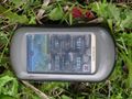
I left a chalk marker on the path whilst waiting for midnight to tick around, and then got my camera out to take the necessary proof, and immediately discovered that it had a completely flat battery! Therefore I had to fall back to my phone camera, which really is completely useless in the dark, as you'll see from the photos. It's sadly impossible to make out the co-ordinates on the photo of my GPS, but you can see that the time is midnight. The top-right number (15 feet) is the GPS accuracy and the middle-left (13 feet) is the distance to the hashpoint. The bottom-right value of 52 feet is the elevation. The GPS tracklog is included below for extra proof. Two more incredibly bad photos were taken, one of the chalk marker I left on the path, and one of the "view" from the hashpoint, which consisted of an out-of-focus shot of a dark path with some street lights in the distance.
I went to leave the area and head home, and almost immediately heard a front door opening behind me. I didn't stop to find out who was coming out of their house!
As hinted at above, I will be returning to the hashpoint in daylight to get a better look at the surroundings, and convince myself that I had absolutely no reason whatsoever to be as paranoid as I felt whilst at the hashpoint.
Expedition 2 (daylight)
I returned to the hashpoint on Monday evening at approximately 7pm, in daylight. Around the corner from the hashpoint, I encountered a small black and white cat which stopped to let me stroke it, but sadly I recognised the cat as "Stitch", belonging to my next-door neighbour, thus rendering it invalid for the Hashcat achievement.
Looking along the row of houses, I was able to see that the row of LEDs belonged to a set of what I think are small solar-powered lanterns that are normally quite popular in gardens, but were instead adorning the balcony handrails. The one that I thought had turned to follow me was mounted in a hanging basket, so entirely probable that it had rotated as I walked past. It's amazing the tricks the mind can play on when you're in an unfamiliar area in the middle of the night!
My chalk marker from the previous night was still present on the floor, although my GPS claimed that the hashpoint was now five steps away from where I'd placed the marker the night before - an interesting lesson in GPS accuracy in built-up areas.
On the way home, I encountered another cat, but this one wasn't willing to come over and be stroked, so the hashcat achievement remained elusive.
Photos
Expedition 1 (midnight)

GPS proof (ish)
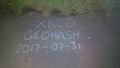
XKCD chalk marker
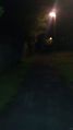
Out-of-focus view from hashpoint
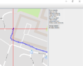
Tracklog map giving better proof


Expedition 2 (daylight)
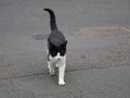
Stitch the non-hashcat
GPS proof
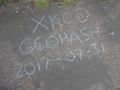
XKCD marker, still present
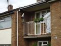
Balcony with lights (not multiple security cameras)
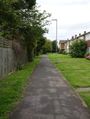
View from hashpoint (same direction as last night's photo)
View from hashpoint (opposite direction)


Achievements

PaintedJaguar earned the Walk geohash Achievement
|
PaintedJaguar earned the Midnight Geohash achievement
|
PaintedJaguar has visited an Easy Geohash
|