Difference between revisions of "2017-08-21 47 12"
imported>Solli |
imported>Solli |
||
| Line 17: | Line 17: | ||
== Expedition == | == Expedition == | ||
| − | I drove the small mountain road above the hashpoint and left my car on a bend. When I walked into the wood I discovered a little path (or ex-path maybe) that was overgrown with | + | I drove the small mountain road above the hashpoint and left my car on a bend. When I walked into the wood I discovered a little path (or ex-path maybe) that was overgrown with great horsetail (Equisetum telmateia) almost as high as me and also thorny stuff. It was quite walkable anyway, but it took me some 80m east of the hashpoint. So I had to go into the wood and follow a deer trail or whatever on the steep slope. I reached what I decided was the point (the GPS signal was not that strong), took some photos and climbed up again. I'd I have earned at least a MNIMB honorably mention. |
== Photos == | == Photos == | ||
<gallery perrow="5"> | <gallery perrow="5"> | ||
Image:2017-08-21 47 12 Solli 01.jpg | There used to be some kind of path | Image:2017-08-21 47 12 Solli 01.jpg | There used to be some kind of path | ||
| − | Image:2017-08-21 47 12 Solli 02.jpg | I have never seen | + | Image:2017-08-21 47 12 Solli 02.jpg | I have never seen horsetail this high |
Image:2017-08-21 47 12 Solli 03.jpg | Lovely wood, but quite steep | Image:2017-08-21 47 12 Solli 03.jpg | Lovely wood, but quite steep | ||
Image:2017-08-21 47 12 Solli 04.jpg | X marks the hashpoint | Image:2017-08-21 47 12 Solli 04.jpg | X marks the hashpoint | ||
Revision as of 07:32, 23 August 2017
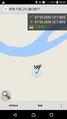
| Mon 21 Aug 2017 in 47,12: 47.6533923, 12.1312924 geohashing.info google osm bing/os kml crox |
Location
On a woody mountain slope near Oberaudorf
Participants
Plans
Since I was climbing near Berchtesgaden this day I decided to make a detour on my way home to Munich.
Expedition
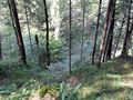
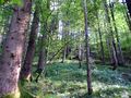
I drove the small mountain road above the hashpoint and left my car on a bend. When I walked into the wood I discovered a little path (or ex-path maybe) that was overgrown with great horsetail (Equisetum telmateia) almost as high as me and also thorny stuff. It was quite walkable anyway, but it took me some 80m east of the hashpoint. So I had to go into the wood and follow a deer trail or whatever on the steep slope. I reached what I decided was the point (the GPS signal was not that strong), took some photos and climbed up again. I'd I have earned at least a MNIMB honorably mention.
Photos
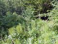
There used to be some kind of path
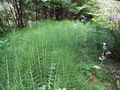
I have never seen horsetail this high
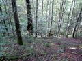
Lovely wood, but quite steep
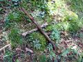
X marks the hashpoint
Proof
View down from the hashpoint

Stupid Grin (tm)
View up from the hashpoint


Achievements
Solli earned the Land geohash achievement
|
Solli achieved level 1 of the Minesweeper Geohash achievement
|