Difference between revisions of "2017-09-02 51 9"
imported>GeorgDerReisende (new report) |
imported>FippeBot m (Location) |
||
| (One intermediate revision by one other user not shown) | |||
| Line 1: | Line 1: | ||
| − | |||
| − | |||
| − | |||
| − | |||
| − | |||
| − | |||
| − | |||
| − | |||
| − | |||
| − | |||
{{meetup graticule | {{meetup graticule | ||
| lat=51 | | lat=51 | ||
| Line 19: | Line 9: | ||
== Location == | == Location == | ||
| − | + | ||
| + | The hash lay 500 meters west of Spangenberg on the national road. | ||
== Participants == | == Participants == | ||
| − | + | ||
| − | + | [[User:GeorgDerReisende|GeorgDerReisende]] | |
== Plans == | == Plans == | ||
| − | + | ||
| + | Hitchhiking. | ||
== Expedition == | == Expedition == | ||
| − | |||
| − | + | I left home at 12 o'clock and started to hitchhike at 12:45. Within two minutes a car stopped and I got a lift to Hessisch Lichtenau. There I had to walk to the very end of the town and at that place I waited very long. Then I got a lift to the next village and again I waited very long. I thought about a xkcd meetup, but I was late. Then a car stopped and I got a lift to the road parking just some meters before the hash. I walked to it and arrived there at 15:57! I took the usual photos and waited there only these minutes, because the hash lay in the inner side of the curve and there was a lot of traffic on the road and I felt dangerous. Then I walked around and found a geocache, only 52 meters away, but out of sight. On the way home I hitchhiked too. And the car passed this hash. But I don't think that I can claim the speed racer achievement, because the hash lay 50 meters behind a 70 km/h-zone and I don't know, if and where the car made it to 100 km/h. | |
| − | |||
== Photos == | == Photos == | ||
| − | |||
| − | |||
| − | |||
<gallery perrow="5"> | <gallery perrow="5"> | ||
| + | Image:2017-09-02 51 9 GeorgDerReisende 0921.jpg | 50 meters to hash on the right side | ||
| + | Image:2017-09-02 51 9 GeorgDerReisende 0922.jpg | this is the wrong side | ||
| + | Image:2017-09-02 51 9 GeorgDerReisende 0923.jpg | the hash | ||
| + | Image:2017-09-02 51 9 GeorgDerReisende 0928.jpg | proof | ||
| + | Image:2017-09-02 51 9 GeorgDerReisende 0929.jpg | the east | ||
| + | Image:2017-09-02 51 9 GeorgDerReisende 0930.jpg | the west | ||
| + | Image:2017-09-02 51 9 GeorgDerReisende 0931.jpg | the south | ||
| + | Image:2017-09-02 51 9 GeorgDerReisende 0935.jpg | the geohasher | ||
| + | Image:2017-09-02 51 9 GeorgDerReisende 0937.jpg | the geocache | ||
| + | Image:2017-09-02 51 9 GeorgDerReisende 0938.jpg | no sight to hash | ||
</gallery> | </gallery> | ||
| Line 45: | Line 42: | ||
<!-- Add any achievement ribbons you earned below, or remove this section --> | <!-- Add any achievement ribbons you earned below, or remove this section --> | ||
| − | + | {{XKCD Centurion | count = 40 | name = GeorgDerReisende }} | |
| − | |||
| − | |||
| − | + | {{Thumbs Up | latitude = 51 | longitude = 9 | date = 2017-09-02 | name = GeorgDerReisende }} | |
| − | + | {{Hash collision | latitude = 51 | longitude = 9 | date = 2017-09-02 | name = GeorgDerReisende | link = http://coord.info/GC4CF3W | id = GC4CF3W | distance = 0.05 km | honor = yes }} | |
| − | |||
| − | |||
| − | |||
| − | + | [[Category:Expeditions]] | |
| − | |||
| − | |||
| − | |||
[[Category:Expeditions with photos]] | [[Category:Expeditions with photos]] | ||
| − | + | ||
| − | |||
| − | |||
| − | |||
| − | |||
[[Category:Coordinates reached]] | [[Category:Coordinates reached]] | ||
| − | + | {{location|DE|HE|HR}} | |
| − | |||
| − | |||
| − | |||
| − | |||
| − | |||
| − | |||
| − | |||
| − | |||
| − | |||
| − | |||
| − | |||
| − | |||
| − | |||
| − | |||
| − | |||
| − | |||
| − | |||
Latest revision as of 02:56, 16 August 2019
| Sat 2 Sep 2017 in 51,9: 51.1140776, 9.6403481 geohashing.info google osm bing/os kml crox |
Location
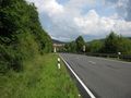
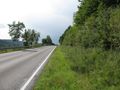
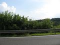
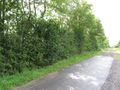
The hash lay 500 meters west of Spangenberg on the national road.
Participants
Plans
Hitchhiking.
Expedition
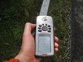
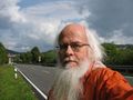
I left home at 12 o'clock and started to hitchhike at 12:45. Within two minutes a car stopped and I got a lift to Hessisch Lichtenau. There I had to walk to the very end of the town and at that place I waited very long. Then I got a lift to the next village and again I waited very long. I thought about a xkcd meetup, but I was late. Then a car stopped and I got a lift to the road parking just some meters before the hash. I walked to it and arrived there at 15:57! I took the usual photos and waited there only these minutes, because the hash lay in the inner side of the curve and there was a lot of traffic on the road and I felt dangerous. Then I walked around and found a geocache, only 52 meters away, but out of sight. On the way home I hitchhiked too. And the car passed this hash. But I don't think that I can claim the speed racer achievement, because the hash lay 50 meters behind a 70 km/h-zone and I don't know, if and where the car made it to 100 km/h.
Photos
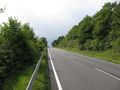
50 meters to hash on the right side
this is the wrong side
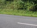
the hash
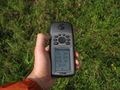
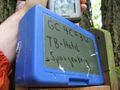
proof
the east
the west
the south
the geohasher
the geocache
no sight to hash


Achievements
GeorgDerReisende earned the xkcd Quadraginturion achievement
|
GeorgDerReisende earned the Thumbs Up Geohash Achievement
|
GeorgDerReisende earned the Hash collision honorable mention
|