Difference between revisions of "2017-09-14 48 11"
From Geohashing
imported>Solli (Created page with "{{subst:Expedition |lat = 48 |lon = 11 |date = 2017-09-14 }}") |
imported>FippeBot m (Location) |
||
| (2 intermediate revisions by one other user not shown) | |||
| Line 1: | Line 1: | ||
| − | |||
| − | |||
| − | |||
| − | |||
| − | |||
| − | |||
| − | |||
| − | |||
| − | |||
| − | |||
{{meetup graticule | {{meetup graticule | ||
| lat=48 | | lat=48 | ||
| Line 15: | Line 5: | ||
}} | }} | ||
| − | |||
__NOTOC__ | __NOTOC__ | ||
== Location == | == Location == | ||
| − | + | In a residential area in Kösching near Ingolstadt | |
== Participants == | == Participants == | ||
| − | + | * [[User:Solli|Solli]] | |
| − | |||
== Plans == | == Plans == | ||
| − | + | Just a 15 minute drive from work, go there on the way home. The hash appears to be on an empty plot, so it should be accessible. | |
== Expedition == | == Expedition == | ||
| − | + | Quick and easy: I drove to Kösching, parked ~15m from the hashpoint, went there, took photos and drove home. | |
| − | + | It was sheer luck that the hash was on a field (probably an empty building plot) and not on private property. The area seems to be quite a posh suburban residential area just a few minutes from Ingolstadt. | |
| − | |||
== Photos == | == Photos == | ||
| − | |||
| − | |||
| − | |||
<gallery perrow="5"> | <gallery perrow="5"> | ||
| + | Image:2017-09-14 48 11 Solli 01.png | Proof | ||
| + | Image:2017-09-14 48 11 Solli 02.jpg | The hashstone | ||
| + | Image:2017-09-14 48 11 Solli 03.jpg | My trusty (rental) hashmobile viewed from the hashpoint | ||
| + | Image:2017-09-14 48 11 Solli 04.jpg | The hashpoint was on the stone in the middle of the picture | ||
| + | Image:2017-09-14 48 11 Solli 05.jpg | Nice area! | ||
</gallery> | </gallery> | ||
== Achievements == | == Achievements == | ||
{{#vardefine:ribbonwidth|800px}} | {{#vardefine:ribbonwidth|800px}} | ||
| − | + | {{land geohash | |
| + | | latitude = 48 | ||
| + | | longitude = 11 | ||
| + | | date = 2017-09-14 | ||
| + | | name = Solli | ||
| + | }} | ||
| − | |||
| − | |||
| − | |||
| − | |||
| − | |||
| − | |||
| − | |||
| − | |||
| − | |||
| − | |||
| − | |||
| − | |||
| − | |||
| − | |||
[[Category:Expeditions]] | [[Category:Expeditions]] | ||
| − | |||
[[Category:Expeditions with photos]] | [[Category:Expeditions with photos]] | ||
| − | |||
| − | |||
| − | |||
| − | |||
| − | |||
[[Category:Coordinates reached]] | [[Category:Coordinates reached]] | ||
| − | + | {{location|DE|BY|EI}} | |
| − | |||
| − | |||
| − | |||
| − | |||
| − | |||
| − | |||
| − | |||
| − | |||
| − | |||
| − | |||
| − | |||
| − | |||
| − | |||
| − | |||
| − | |||
| − | |||
| − | |||
Latest revision as of 02:58, 16 August 2019
| Thu 14 Sep 2017 in 48,11: 48.8197840, 11.5076870 geohashing.info google osm bing/os kml crox |
Location
In a residential area in Kösching near Ingolstadt
Participants
Plans
Just a 15 minute drive from work, go there on the way home. The hash appears to be on an empty plot, so it should be accessible.
Expedition
Quick and easy: I drove to Kösching, parked ~15m from the hashpoint, went there, took photos and drove home.
It was sheer luck that the hash was on a field (probably an empty building plot) and not on private property. The area seems to be quite a posh suburban residential area just a few minutes from Ingolstadt.
Photos
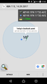
Proof
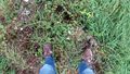
The hashstone
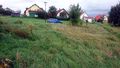
My trusty (rental) hashmobile viewed from the hashpoint
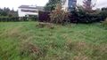
The hashpoint was on the stone in the middle of the picture
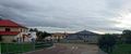
Nice area!


Achievements
Solli earned the Land geohash achievement
|