Difference between revisions of "2017-09-18 47 -122"
imported>Thomcat ([live picture]South Rose Hill [http://www.openstreetmap.org/?lat=47.66911890&lon=-122.18508580&zoom=16&layers=B000FTF @47.6691,-122.1851]) |
imported>FippeBot m (Location) |
||
| (4 intermediate revisions by one other user not shown) | |||
| Line 19: | Line 19: | ||
== Expedition == | == Expedition == | ||
<!-- how it all turned out. your narrative goes here. --> | <!-- how it all turned out. your narrative goes here. --> | ||
| + | South Rose Hill is just a few freeway stops south of my office in Canyon Park. I left work about 3:30 and headed towards today's geohashpoint. | ||
| + | |||
| + | According to google maps, the point is in front of the house, close to where the electric meter would be. I parked in front of the house and took a few preliminary pictures (below). I then stepped onto the lawn and was pretty much at the point. | ||
| + | |||
| + | Not sure if it was cloud cover (very overcast!) or other conditions, but the GPS error window kept growing and shrinking. Rather than dance around on the slightly damp lawn looking for a zero reading, I figured it was better to claim success from a few meters away. | ||
| + | |||
| + | I dropped a flyer in the mailbox and headed for home, hitting a few patches of rain in the process. I just hope some of that rain goes where the wildfires are still burning. | ||
== Tracklog == | == Tracklog == | ||
| Line 30: | Line 37: | ||
Image:2017-09-18_47_-122_thomcat_1505774303359.jpg|South Rose Hill [http://www.openstreetmap.org/?lat=47.66911890&lon=-122.18508580&zoom=16&layers=B000FTF @47.6691,-122.1851] | Image:2017-09-18_47_-122_thomcat_1505774303359.jpg|South Rose Hill [http://www.openstreetmap.org/?lat=47.66911890&lon=-122.18508580&zoom=16&layers=B000FTF @47.6691,-122.1851] | ||
| + | |||
| + | Image:2017-09-18_47_-122_thomcat_1505774524304.jpg|Location [http://www.openstreetmap.org/?lat=47.66660640&lon=-122.17829550&zoom=16&layers=B000FTF @47.6666,-122.1783] | ||
| + | |||
| + | Image:2017-09-18_47_-122_thomcat_1505774549302.jpg|Geohasher [http://www.openstreetmap.org/?lat=47.66655350&lon=-122.17831030&zoom=16&layers=B000FTF @47.6666,-122.1783] | ||
</gallery> | </gallery> | ||
== Achievements == | == Achievements == | ||
{{#vardefine:ribbonwidth|800px}} | {{#vardefine:ribbonwidth|800px}} | ||
| − | + | {{Last man standing | |
| − | + | | latitude = 47 | |
| + | | longitude = -122 | ||
| + | | date = 2017-09-18 | ||
| + | | gender = man | ||
| + | | name = Thomcat | ||
| + | | image = 2017-09-18_47_-122_thomcat_1505774549302.jpg | ||
| + | }} | ||
| − | |||
| − | |||
| − | |||
[[Category:Expeditions]] | [[Category:Expeditions]] | ||
[[Category:Expeditions with photos]] | [[Category:Expeditions with photos]] | ||
[[Category:Coordinates reached]] | [[Category:Coordinates reached]] | ||
| − | + | {{location|US|WA|KN}} | |
| − | |||
| − | |||
| − | |||
| − | |||
| − | |||
| − | |||
| − | |||
| − | |||
| − | |||
| − | |||
Latest revision as of 02:59, 16 August 2019
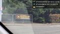
| Mon 18 Sep 2017 in Seattle: 47.6665554, -122.1783646 geohashing.info google osm bing/os kml crox |
Location
Driveway of a house in south Rose Hill, Kirkland.
Participants
Plans
Stop by after work.
Expedition
South Rose Hill is just a few freeway stops south of my office in Canyon Park. I left work about 3:30 and headed towards today's geohashpoint.
According to google maps, the point is in front of the house, close to where the electric meter would be. I parked in front of the house and took a few preliminary pictures (below). I then stepped onto the lawn and was pretty much at the point.
Not sure if it was cloud cover (very overcast!) or other conditions, but the GPS error window kept growing and shrinking. Rather than dance around on the slightly damp lawn looking for a zero reading, I figured it was better to claim success from a few meters away.
I dropped a flyer in the mailbox and headed for home, hitting a few patches of rain in the process. I just hope some of that rain goes where the wildfires are still burning.
Tracklog
Photos
South Rose Hill @47.6691,-122.1851
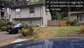
Location @47.6666,-122.1783

Geohasher @47.6666,-122.1783


Achievements
Thomcat earned the Last man standing achievement
|