Difference between revisions of "2017-10-09 51 9"
imported>GeorgDerReisende (new report) |
imported>GeorgDerReisende (expedition report for Kassel-Waldau) |
||
| Line 1: | Line 1: | ||
| − | |||
| − | |||
| − | |||
| − | |||
| − | |||
| − | |||
| − | |||
| − | |||
| − | |||
| − | |||
{{meetup graticule | {{meetup graticule | ||
| lat=51 | | lat=51 | ||
| Line 19: | Line 9: | ||
== Location == | == Location == | ||
| − | + | The hash lay at the side of the busstop ''Berufsbildungszentrum'' in Kassel-Waldau. | |
== Participants == | == Participants == | ||
| − | + | ||
| − | + | [[User:GeorgDerReisende|GeorgDerReisende]] | |
== Plans == | == Plans == | ||
| − | + | ||
| + | I found a connection between this hash and the [[2017-10-09 52 9]] hash. I never noticed that my best loved mountain ''Deister'' lay at the same coordinates like Kassel, but only one graticule more north. So I decided to visit both. But at the morning I had an appointment at the Jobcenter. | ||
== Expedition == | == Expedition == | ||
| − | |||
| − | + | I left the jobcenter at 9:35 and went to the busstop. I took the bus 17, which brought me right to the bus stop ''Berufsbildungszentrum''. There were only some steps to go. At first I found the hash at the right side of the footway. I wanted to write a mark on the footway and the marker wandered to the left side of the footway. I decided the hash to be in the middle of both points and in the middle of the footway. After this hash I started to the another. | |
| − | |||
== Photos == | == Photos == | ||
| Line 39: | Line 28: | ||
--> | --> | ||
<gallery perrow="5"> | <gallery perrow="5"> | ||
| + | Image:2017-10-09 51 9 GeorgDerReisende 2803.jpg | arrived | ||
| + | Image:2017-10-09 51 9 GeorgDerReisende 2806.jpg | proof on the rigth side | ||
| + | Image:2017-10-09 51 9 GeorgDerReisende 2808.jpg | proof on the left side | ||
| + | Image:2017-10-09 51 9 GeorgDerReisende 2809.jpg | view to the east | ||
| + | Image:2017-10-09 51 9 GeorgDerReisende 2810.jpg | view to the south | ||
| + | Image:2017-10-09 51 9 GeorgDerReisende 2811.jpg | view to the north | ||
| + | Image:2017-10-09 51 9 GeorgDerReisende 2812.jpg | view to the west | ||
| + | Image:2017-10-09 51 9 GeorgDerReisende 2813.jpg | the geohasher | ||
</gallery> | </gallery> | ||
| Line 45: | Line 42: | ||
<!-- Add any achievement ribbons you earned below, or remove this section --> | <!-- Add any achievement ribbons you earned below, or remove this section --> | ||
| − | + | {{Public transport geohash | latitude = 51 | longitude = 9 | date = 2017-10-09 | busline = tram 17 | name = GeorgDerReisende }} | |
| − | |||
| − | |||
| − | + | {{Easy_geohash | latitude = 51 | longitude = 9 | date = 2017-10-09 | name = GeorgDerReisende }} | |
| − | + | [[Category:Expeditions]] | |
| − | |||
| − | [[Category: | ||
| − | |||
| − | + | [[Category:Expeditions with photos]] | |
| − | |||
| − | |||
| − | |||
| − | |||
| − | |||
| − | |||
| − | |||
| − | |||
| − | |||
[[Category:Coordinates reached]] | [[Category:Coordinates reached]] | ||
| − | |||
| − | |||
| − | |||
| − | |||
| − | |||
| − | |||
| − | |||
| − | |||
| − | |||
| − | |||
| − | |||
| − | |||
| − | |||
| − | |||
| − | |||
| − | |||
| − | |||
| − | |||
Revision as of 14:40, 10 October 2017
| Mon 9 Oct 2017 in 51,9: 51.2830050, 9.4986228 geohashing.info google osm bing/os kml crox |
Location
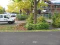
The hash lay at the side of the busstop Berufsbildungszentrum in Kassel-Waldau.
Participants
Plans
I found a connection between this hash and the 2017-10-09 52 9 hash. I never noticed that my best loved mountain Deister lay at the same coordinates like Kassel, but only one graticule more north. So I decided to visit both. But at the morning I had an appointment at the Jobcenter.
Expedition
I left the jobcenter at 9:35 and went to the busstop. I took the bus 17, which brought me right to the bus stop Berufsbildungszentrum. There were only some steps to go. At first I found the hash at the right side of the footway. I wanted to write a mark on the footway and the marker wandered to the left side of the footway. I decided the hash to be in the middle of both points and in the middle of the footway. After this hash I started to the another.
Photos
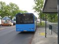
arrived
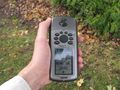
proof on the rigth side
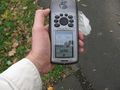
proof on the left side
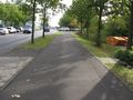
view to the east
view to the south
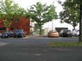
view to the north

view to the west
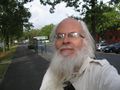
the geohasher


Achievements
GeorgDerReisende earned the Public transport geohash achievement
|
GeorgDerReisende has visited an Easy Geohash
|