Difference between revisions of "2017-10-14 42 -78"
imported>Pedalpusher (new expedition report) |
imported>Pedalpusher (finally added photos) |
||
| Line 18: | Line 18: | ||
== Photos == | == Photos == | ||
<gallery perrow="7"> | <gallery perrow="7"> | ||
| − | Image: | + | Image: 2017-10-14 gps.jpg | Made it. |
| − | Image: | + | Image: 2017-10-14 gps2.jpg | Accuracy. |
| − | Image: | + | Image: 2017-10-14 hashDogs.jpg | The dogs sitting nicely for their picture at the hash. |
| − | Image: | + | Image: 2017-10-14 hashWoods.jpg | A view of the hash and the woods. |
| − | Image: | + | Image: 2017-10-14 stupidGrin.jpg | Standard Stupid Grin. |
| − | Image: | + | Image: 2017-10-14 rocks.jpg | On the way out, I passed this hardy tree growing on the boulders. |
| − | |||
| − | |||
</gallery> | </gallery> | ||
| Line 34: | Line 32: | ||
| date = 2017-10-14 | | date = 2017-10-14 | ||
}} | }} | ||
| + | {{xkcd centurion|count=11| name=Pedalpusher}} | ||
| − | |||
[[Category:Expeditions]] | [[Category:Expeditions]] | ||
[[Category:Coordinates reached]] | [[Category:Coordinates reached]] | ||
| − | + | [[Category:Expeditions with photos]] | |
[[Category:Expeditions with dogs]] | [[Category:Expeditions with dogs]] | ||
Revision as of 17:54, 23 November 2017
| Sat 14 Oct 2017 in 42,-78: 42.0712921, -78.7524743 geohashing.info google osm bing/os kml crox |
Location
Allegany State Park, in the woods off ASP Rt 1.
Participants
- Pedalpusher
- Simon the dog
- Myka the dog
Expedition
My first expedition in over a month, I'm happy to see the hash land in Allegany again. This is actually just south of my expedition on 2017-04-26. It was really close to a Deja Vu too as I walked by this area on my way to the geocache that day too. This would have also been a Hash Collision with the same cache, but the permit expired a few days after that expedition and it doesn't look like it was renewed.
Being a Saturday, we left the house a little after 14:00 to give us some time to spare for an Official Saturday Meetup time. We got to Allegany with about 15 minutes to spare and it was a short hike into the woods to find the hash. A short GPS dance found the range and the pictures were taken. Not being on an expedition for so long, I totally forgot to grab a screenshot of the time but at least the meta-data shows I was there pretty close to the official 16:00 meetup time.
With a few hours of light remaining, we drove over to the Quaker area and hiked the Black Snake Mtn trail. It's the southern-most trail in the park and we touched Pennsylvania before heading for home.
Photos
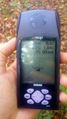
Made it.
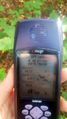
Accuracy.
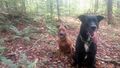
The dogs sitting nicely for their picture at the hash.
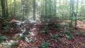
A view of the hash and the woods.

Standard Stupid Grin.
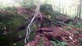
On the way out, I passed this hardy tree growing on the boulders.


Ribbons
This user earned the Land geohash achievement
|
Pedalpusher earned the xkcd Decurion achievement
|