Difference between revisions of "2017-10-21 43 -79"
imported>Frogman ([live] M M) |
m (More specific location) |
||
| (21 intermediate revisions by 2 users not shown) | |||
| Line 19: | Line 19: | ||
== Location == | == Location == | ||
| − | + | On the side of a road near a forested area in Ajax, Ontario. | |
== Participants == | == Participants == | ||
| − | + | * [[User:Frogman|Frogman]] | |
| − | |||
| − | |||
| − | |||
| − | |||
== Expedition == | == Expedition == | ||
| − | + | I got up at the early hour of noon and left the house by 2. After a fairly uneventful drive, I stopped at a trailhead near a dog park. I could have drove all the way to the hashpoint, but it was a fine day for a walk! Many people were out with their dogs or bikes. | |
| + | The trail went parallel to the road for a while, and then branched off into a forested area with a lot of lakes. It seemed to be some sort of river delta, draining into Lake Ontario. Eventually the trail met up with the road again. The hashpoint was between the sidewalk and the road, near a memorial tree. | ||
| − | + | After getting to the hashpoint, I walked down to Lake Ontario (it was so close!) via Rotary Park. I sat on a bench overlooking the shoreline, doing some homework. | |
| − | |||
| − | |||
| − | |||
== Photos == | == Photos == | ||
| Line 42: | Line 36: | ||
--> | --> | ||
<gallery perrow="5"> | <gallery perrow="5"> | ||
| − | |||
| − | + | Image:2017-10-21_43_-79_frogman_1508634748503.jpg|A map of the trail system at the trailhead. | |
| − | + | ||
| − | + | Image:2017-10-21_43_-79_frogman_1508634770140.jpg|What a gorgeous day for a walk! | |
| + | |||
| + | Image:2017-10-21_43_-79_frogman_1508634787329.jpg|Don't eat the plants | ||
| + | |||
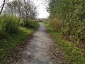
| + | Image:2017-10-21_43_-79_frogman_1508634824633.jpg|The trail goes through this area with a lot of smaller lakes. | ||
| + | |||
| + | Image:2017-10-21_43_-79_frogman_1508634853080.jpg|Made it! | ||
| + | |||
| + | Image:2017-10-21_43_-79_frogman_1508634884414.jpg|Southeast from the hashpoint | ||
| + | |||
| + | Image:2017-10-21_43_-79_frogman_1508634898625.jpg|To the northwest | ||
| − | + | Image:2017-10-21_43_-79_frogman_1508634914190.jpg|Goofy grin! | |
| − | |||
| − | |||
| − | + | Image:2017-10-21_43_-79_frogman_1508634929620.jpg|Memorial tree | |
| − | + | Image:2017-10-21_43_-79_frogman_1508634958635.jpg|A note explaining the memorial tree | |
| − | |||
| − | |||
| − | |||
| − | + | Image:2017-10-21_43_-79_frogman_1508634979053.jpg|The lake closest to the hashpoint | |
| − | + | Image:2017-10-21_43_-79_frogman_1508634999964.jpg|Near the mouth of the river. | |
| − | |||
| − | -- | ||
| − | |||
| − | |||
| − | |||
| − | |||
| − | |||
| − | |||
| − | |||
| + | Image:2017-10-21_43_-79_frogman_1508635017586.jpg|Lake Ontario! | ||
| − | + | Image:2017-10-21_43_-79_frogman_1508635048012.jpg|One could barely see the CN tower from the park. | |
| − | + | </gallery> | |
| − | |||
| − | |||
| − | |||
| − | |||
| − | |||
| − | |||
| − | |||
| − | |||
| − | |||
| − | |||
| − | |||
| − | + | [[Category:Expeditions]] | |
| + | [[Category:Expeditions with photos]] | ||
| + | [[Category:Coordinates reached]] | ||
| + | {{location|CA|ON|DR}} | ||
Latest revision as of 00:13, 10 August 2020
| Sat 21 Oct 2017 in 43,-79: 43.8219989, -79.0340213 geohashing.info google osm bing/os kml crox |
Location
On the side of a road near a forested area in Ajax, Ontario.
Participants
Expedition
I got up at the early hour of noon and left the house by 2. After a fairly uneventful drive, I stopped at a trailhead near a dog park. I could have drove all the way to the hashpoint, but it was a fine day for a walk! Many people were out with their dogs or bikes.
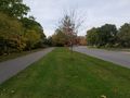
The trail went parallel to the road for a while, and then branched off into a forested area with a lot of lakes. It seemed to be some sort of river delta, draining into Lake Ontario. Eventually the trail met up with the road again. The hashpoint was between the sidewalk and the road, near a memorial tree.
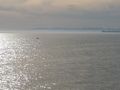
After getting to the hashpoint, I walked down to Lake Ontario (it was so close!) via Rotary Park. I sat on a bench overlooking the shoreline, doing some homework.
Photos
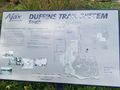
A map of the trail system at the trailhead.
What a gorgeous day for a walk!
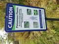
Don't eat the plants

The trail goes through this area with a lot of smaller lakes.
Made it!
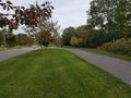
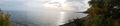
Southeast from the hashpoint
To the northwest

Goofy grin!
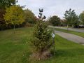
Memorial tree
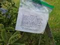
A note explaining the memorial tree
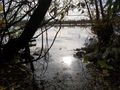
The lake closest to the hashpoint
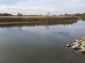
Near the mouth of the river.
Lake Ontario!
One could barely see the CN tower from the park.


