Difference between revisions of "2017-11-10 43 -79"
From Geohashing
imported>Frogman ([live picture]The view of the geohasher) |
m (More specific location) |
||
| (4 intermediate revisions by 2 users not shown) | |||
| Line 1: | Line 1: | ||
| + | [[Image:{{{image|2017-11-10 43 -79 frogman 1510372266263.jpg}}}|thumb|left]] | ||
| − | |||
| − | |||
| − | |||
| − | |||
| − | |||
| − | |||
| − | |||
| − | |||
| − | |||
{{meetup graticule | {{meetup graticule | ||
| lat=43 | | lat=43 | ||
| Line 15: | Line 7: | ||
}} | }} | ||
| − | |||
__NOTOC__ | __NOTOC__ | ||
== Location == | == Location == | ||
| − | + | On a sidewalk on O'Connor near Woodbine. | |
== Participants == | == Participants == | ||
| − | + | * [[User:Frogman|Frogman]] | |
| − | |||
| − | |||
| − | |||
| − | |||
== Expedition == | == Expedition == | ||
| − | + | I was at school late playing board games, so it was pretty late by the time I started heading home. I got off at Woodbine Station, a couple of stations earlier than usual, and took the bus up to this fairly easy hashpoint. Then, I took the bus home. Brr, it was chilly! Certainly cold enough for the Frozen Geohash achievement, as the high today was -2, although I don't have the exact temperature at the hashpoint at the time I was there. | |
| − | |||
| − | |||
| − | |||
| − | |||
| − | |||
== Photos == | == Photos == | ||
| Line 55: | Line 37: | ||
Image:2017-11-10_43_-79_frogman_1510372288220.jpg|The view of the geohasher | Image:2017-11-10_43_-79_frogman_1510372288220.jpg|The view of the geohasher | ||
| + | |||
| + | Image:2017-11-10_43_-79_frogman_1510372305349.jpg|A nearby bus stop | ||
</gallery> | </gallery> | ||
== Achievements == | == Achievements == | ||
{{#vardefine:ribbonwidth|800px}} | {{#vardefine:ribbonwidth|800px}} | ||
| − | + | {{Frozen Geohash | |
| − | |||
| − | |||
| − | |||
| − | |||
| − | + | | latitude = 43 | |
| + | | longitude = -79 | ||
| + | | date = 2017-11-10 | ||
| + | | name = [[User:Frogman|Frogman]] | ||
| − | + | }} | |
| − | + | {{Public transport geohash | |
| − | |||
| − | |||
| − | + | | latitude = 43 | |
| + | | longitude = -79 | ||
| + | | date = 2017-11-10 | ||
| + | | busline = the TTC | ||
| + | | name = [[User:Frogman|Frogman]] | ||
| + | | image = 2017-11-10_43_-79_frogman_1510372305349.jpg | ||
| − | + | }} | |
[[Category:Expeditions]] | [[Category:Expeditions]] | ||
| − | |||
[[Category:Expeditions with photos]] | [[Category:Expeditions with photos]] | ||
| − | |||
| − | |||
| − | |||
| − | |||
| − | |||
[[Category:Coordinates reached]] | [[Category:Coordinates reached]] | ||
| − | + | {{location|CA|ON|TO}} | |
| − | |||
| − | |||
| − | |||
| − | |||
| − | |||
| − | |||
| − | |||
| − | |||
| − | |||
| − | |||
| − | |||
| − | |||
| − | |||
| − | |||
| − | |||
| − | |||
| − | |||
Latest revision as of 00:14, 10 August 2020

| Fri 10 Nov 2017 in 43,-79: 43.6995713, -79.3203841 geohashing.info google osm bing/os kml crox |
Location
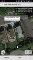
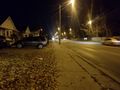
On a sidewalk on O'Connor near Woodbine.
Participants
Expedition
I was at school late playing board games, so it was pretty late by the time I started heading home. I got off at Woodbine Station, a couple of stations earlier than usual, and took the bus up to this fairly easy hashpoint. Then, I took the bus home. Brr, it was chilly! Certainly cold enough for the Frozen Geohash achievement, as the high today was -2, although I don't have the exact temperature at the hashpoint at the time I was there.
Photos
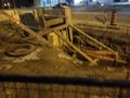
A nearby construction hole
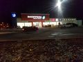
A nearby store
Made it!
The view east
The view west
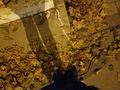
The view down

The view of the geohasher
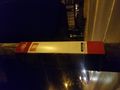
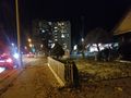
A nearby bus stop


Achievements

Frogman earned the Frozen Geohash Achievement
by reaching the (43, -79) geohash on 2017-11-10 while the temperature was below the freezing point of water.
Frogman earned the Public transport geohash achievement
|