Difference between revisions of "2018-01-28 47 -122"
imported>Thomcat ([live picture]They indeed [http://www.openstreetmap.org/?lat=47.80682960&lon=-122.28706600&zoom=16&layers=B000FTF @47.8068,-122.2871]) |
imported>FippeBot m (Location) |
||
| (4 intermediate revisions by one other user not shown) | |||
| Line 18: | Line 18: | ||
== Expedition == | == Expedition == | ||
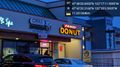
| − | + | On the road before sunrise, but arrival would be after. Why not stop for a donut? | |
| + | |||
| + | Drove to the spot, parking on it, and took my faithful hashdog companion for a stroll down the path. We reached a few neighborhoods, and after returning to the car, drove slightly west and walked up another path to Mountlake Terrace High School, where I have worked many baseball games in the past. Pictures below. | ||
| + | |||
| + | Interestingly, I returned to my computer to google "dawn seattle" which gave me a time of 7:06 am (tomorrow). Then I googled "sunrise seattle" and got 7:39 am. Twilight is the name given to the time between dawn and sunrise, between dusk and sunset, and it can apparently be measured. Learned this and many other facts here: [http://wordpress.mrreid.org/2013/02/05/dawn-dusk-sunrise-sunset-and-twilight/ MrReid.org]. I would think this would also change based on weather conditions - heavy clouds reduce the pre-sunrise light - but what do I know? | ||
== Tracklog == | == Tracklog == | ||
| Line 38: | Line 42: | ||
Image:2018-01-28_47_-122_thomcat_1517155335791.jpg|They indeed [http://www.openstreetmap.org/?lat=47.80682960&lon=-122.28706600&zoom=16&layers=B000FTF @47.8068,-122.2871] | Image:2018-01-28_47_-122_thomcat_1517155335791.jpg|They indeed [http://www.openstreetmap.org/?lat=47.80682960&lon=-122.28706600&zoom=16&layers=B000FTF @47.8068,-122.2871] | ||
| + | |||
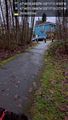
| + | Image:2018-01-28_47_-122_thomcat_1517155439505.jpg|Use path [http://www.openstreetmap.org/?lat=47.80650730&lon=-122.28675290&zoom=16&layers=B000FTF @47.8065,-122.2868] | ||
| + | |||
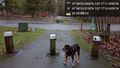
| + | Image:2018-01-28_47_-122_thomcat_1517155750235.jpg|hasher [http://www.openstreetmap.org/?lat=47.80572730&lon=-122.28666370&zoom=16&layers=B000FTF @47.8057,-122.2867] | ||
| + | |||
| + | Image:2018-01-28_47_-122_thomcat_1521843582984.jpg|Teams warming up [http://www.openstreetmap.org/?lat=47.80285820&lon=-122.28679700&zoom=16&layers=B000FTF @47.8029,-122.2868] | ||
</gallery> | </gallery> | ||
| Line 44: | Line 54: | ||
<!-- Add any achievement ribbons you earned below, or remove this section --> | <!-- Add any achievement ribbons you earned below, or remove this section --> | ||
| − | |||
| − | |||
| − | |||
| − | |||
[[Category:Expeditions]] | [[Category:Expeditions]] | ||
[[Category:Expeditions with photos]] | [[Category:Expeditions with photos]] | ||
[[Category:Coordinates reached]] | [[Category:Coordinates reached]] | ||
| − | + | {{location|US|WA|SN}} | |
| − | |||
| − | |||
| − | |||
| − | |||
| − | |||
| − | |||
| − | |||
| − | |||
| − | |||
| − | |||
Latest revision as of 03:19, 16 August 2019
| Sun 28 Jan 2018 in Seattle: 47.8057487, -122.2866554 geohashing.info google osm bing/os kml crox |
Location
A residential street in Mountlake Terrace, quite close to the High School.
Participants
Plans
Dawn visit, perhaps? No particular plans.
Expedition
On the road before sunrise, but arrival would be after. Why not stop for a donut?
Drove to the spot, parking on it, and took my faithful hashdog companion for a stroll down the path. We reached a few neighborhoods, and after returning to the car, drove slightly west and walked up another path to Mountlake Terrace High School, where I have worked many baseball games in the past. Pictures below.
Interestingly, I returned to my computer to google "dawn seattle" which gave me a time of 7:06 am (tomorrow). Then I googled "sunrise seattle" and got 7:39 am. Twilight is the name given to the time between dawn and sunrise, between dusk and sunset, and it can apparently be measured. Learned this and many other facts here: MrReid.org. I would think this would also change based on weather conditions - heavy clouds reduce the pre-sunrise light - but what do I know?
Tracklog
Photos
Dawn in 5 min, but not under these clouds @47.7089,-122.3335

Parked @47.8058,-122.2867
Path to geohashpoint @47.8059,-122.2870
Hashdog @47.8064,-122.2872
They indeed @47.8068,-122.2871
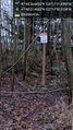
Use path @47.8065,-122.2868

hasher @47.8057,-122.2867
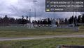
Teams warming up @47.8029,-122.2868


