Difference between revisions of "2018-01-31 52 1"
From Geohashing
imported>Sourcerer (An expedition message sent via Geohash Droid for Android.) |
imported>FippeBot m (Location) |
||
| (8 intermediate revisions by one other user not shown) | |||
| Line 1: | Line 1: | ||
| − | + | {{meetup graticule | |
| − | |||
| − | |||
| − | |||
| − | |||
| − | |||
| − | |||
| − | |||
| − | |||
| − | |||
| − | {{meetup graticule | ||
| lat=52 | | lat=52 | ||
| lon=1 | | lon=1 | ||
| date=2018-01-31 | | date=2018-01-31 | ||
| + | | graticule_name=Norwich, UK | ||
| + | | graticule_link=Norwich, United Kingdom | ||
}} | }} | ||
| − | |||
| − | |||
__NOTOC__ | __NOTOC__ | ||
| + | == Location == | ||
| − | + | A field perimeter footpath at Rumburgh, Suffolk UK. | |
| − | |||
== Participants == | == Participants == | ||
| − | + | ||
| − | + | [[User:Sourcerer|Sourcerer]] | |
== Plans == | == Plans == | ||
| − | + | ||
| + | Get up at 3 am (01:00 UTC). Catch the Ryanair flight from Paphos, Cyprus to London, Stansted. Have a brief rest and then go geohashing. | ||
| + | |||
== Expedition == | == Expedition == | ||
| − | |||
| − | == | + | *Arrived. -- [[User:Sourcerer|Sourcerer]] ([[User talk:Sourcerer|talk]]) [http://www.openstreetmap.org/?lat=52.38206148&lon=1.45104825&zoom=16&layers=B000FTF @52.3821,1.4510] 19:02, 31 January 2018 (GMT+02:00) |
| − | |||
| − | == Photos == | + | Catch a hashpoint while flying over [[2018-01-31_43_19|Montenegro]]. Travel another 1670 km to make it a double-hash 8 km from home. |
| − | < | + | |
| − | Image: | + | == Photos == |
| − | -- | + | <gallery caption="Gallery" widths="200px" heights="200px" perrow="3"> |
| − | + | Image:2018-01-31_52_1_Sourcerer_1517418232682.jpg | Proof. [http://www.openstreetmap.org/?lat=52.38207221&lon=1.45103753&zoom=16&layers=B000FTF @52.3821,1.4510] | |
| + | Image:2018-01-31_52_1_Sourcerer.jpg | Google Earth Track | ||
</gallery> | </gallery> | ||
== Achievements == | == Achievements == | ||
{{#vardefine:ribbonwidth|800px}} | {{#vardefine:ribbonwidth|800px}} | ||
| − | |||
| − | + | {{Multihash2 | |
| − | + | | date = 2018-01-31 | |
| − | + | | name = Sourcerer | |
| + | | count = 2 | ||
| + | }} | ||
| − | + | Last man standing twice on the same day... | |
| − | + | {{Last man standing | |
| − | + | | latitude = 43 | |
| − | + | | longitude = 19 | |
| − | + | | date = 2018-01-31 | |
| + | | name = Sourcerer | ||
| + | | gender = man | ||
| + | }} | ||
| − | + | {{Sourcerer_links | |
| + | | prev = 2018-01-31 43 19 | ||
| + | | curr = 2018-01-31 52 1 | ||
| + | | next = 2018-02-05 52 1 | ||
| + | | date = 2018-01-31 | ||
| + | }} | ||
| − | |||
[[Category:Expeditions]] | [[Category:Expeditions]] | ||
| − | |||
[[Category:Expeditions with photos]] | [[Category:Expeditions with photos]] | ||
| − | |||
| − | |||
| − | |||
| − | |||
| − | |||
[[Category:Coordinates reached]] | [[Category:Coordinates reached]] | ||
| − | + | {{location|GB|ENG|SFK}} | |
| − | |||
| − | |||
| − | |||
| − | |||
| − | |||
| − | |||
| − | |||
| − | |||
| − | |||
| − | |||
| − | |||
| − | |||
| − | |||
| − | |||
| − | |||
| − | |||
| − | |||
Latest revision as of 03:20, 16 August 2019
| Wed 31 Jan 2018 in Norwich, UK: 52.3820538, 1.4510360 geohashing.info google osm bing/os kml crox |
Location
A field perimeter footpath at Rumburgh, Suffolk UK.
Participants
Plans
Get up at 3 am (01:00 UTC). Catch the Ryanair flight from Paphos, Cyprus to London, Stansted. Have a brief rest and then go geohashing.
Expedition
- Arrived. -- Sourcerer (talk) @52.3821,1.4510 19:02, 31 January 2018 (GMT+02:00)
Catch a hashpoint while flying over Montenegro. Travel another 1670 km to make it a double-hash 8 km from home.
Photos
- Gallery
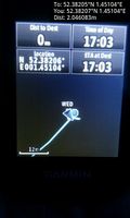
Proof. @52.3821,1.4510
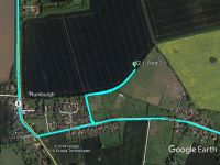
Google Earth Track


Achievements
Sourcerer earned the Multihash Achievement
|
Last man standing twice on the same day...
Sourcerer earned the Last man standing achievement
|
Expeditions and Plans
| 2018-01-31 | ||
|---|---|---|
| Prijepolje, Serbia | Sourcerer | Half way between and 11.5 km above Krnjača and Jabuka, Montenegro, flying a... |
| Norwich, United Kingdom | Sourcerer | A field perimeter footpath at Rumburgh, Suffolk UK. |
Sourcerer's Expedition Links
2018-01-31 43 19 - 2018-01-31 52 1 - 2018-02-05 52 1 - KML file download of Sourcerer's expeditions for use with Google Earth.