Difference between revisions of "2018-03-04 49 8"
imported>DODO (→Location) |
imported>FippeBot m (Location) |
||
| (4 intermediate revisions by one other user not shown) | |||
| Line 25: | Line 25: | ||
<!-- who attended: If you link to your wiki user name in this section, your expedition will be picked up by the various statistics generated for geohashing. You may use three tildes ~ as a shortcut to automatically insert the user signature of the account you are editing with. | <!-- who attended: If you link to your wiki user name in this section, your expedition will be picked up by the various statistics generated for geohashing. You may use three tildes ~ as a shortcut to automatically insert the user signature of the account you are editing with. | ||
--> | --> | ||
| + | [[User:DODO|DODO]] | ||
== Plans == | == Plans == | ||
<!-- what were the original plans --> | <!-- what were the original plans --> | ||
| + | Go there by bull. ETA: 15:00 | ||
== Expedition == | == Expedition == | ||
<!-- how it all turned out. your narrative goes here. --> | <!-- how it all turned out. your narrative goes here. --> | ||
| + | I left home at 13:15 and had a nice ride in an early spring day. It has been very cold in Germany last week so the air felt pretty warm today. The track wasn't that nice, I had to ride through Ludwigshafen and Mannheim, what is mostly industrial area. And even after I've left Mannheim I had to follow the train track or a busy road. But in the end I left the road and followed an unpaved path. where I reached the hash field. I had to walk 150 m into the field, but that was doable without any problems. I could see the church of Biblis (where I wanted to enter the train) already, and 15 minutes after I reached the hash, I reached Biblis. I knew that I have more than half an hour left until my train came, and so I rode around to find a location to celebrate my success, but there was no cafe or ice vendor in Biblis. So I drove to the station, just in time to reach the train before mine, and entered it. During the ride I found out, that my original train would have been late, and I wouldn't have catchen the train to Speyer, if I had missed the earlier one. But so, I reached home at 17:15 again. | ||
== Tracklog == | == Tracklog == | ||
<!-- if your GPS device keeps a log, you may post a link here --> | <!-- if your GPS device keeps a log, you may post a link here --> | ||
| − | + | [https://www.komoot.de/tour/27507189 54 KM by bull and 47 km by train] | |
== Photos == | == Photos == | ||
<!-- Insert pictures between the gallery tags using the following format: | <!-- Insert pictures between the gallery tags using the following format: | ||
Image:2012-##-## ## ## Alpha.jpg | Witty Comment | Image:2012-##-## ## ## Alpha.jpg | Witty Comment | ||
--> | --> | ||
| − | <gallery perrow=" | + | <gallery perrow="4"> |
| + | Image:2018-03-03 49 8-1.jpg|view to the hash (150 m to go) | ||
| + | Image:2018-03-03 49 8-2.jpg|bull | ||
| + | Image:2018-03-03 49 8-7.jpg|proof | ||
| + | Image:2018-03-03 49 8-3.jpg|view back to the bull (very small in the middle) | ||
| + | Image:2018-03-03 49 8-4.jpg|and to the other (western) direction | ||
| + | Image:2018-03-03 49 8-5.jpg|in the north you can already see Biblis | ||
| + | Image:2018-03-03 49 8-6.jpg|a happy hasher | ||
</gallery> | </gallery> | ||
== Achievements == | == Achievements == | ||
{{#vardefine:ribbonwidth|800px}} | {{#vardefine:ribbonwidth|800px}} | ||
| − | + | {{land geohash | |
| − | + | | latitude = 48 | |
| − | + | | longitude = 8 | |
| − | + | | date = 2018-02-25 | |
| − | + | | name = DODO | |
| − | + | }} | |
| − | |||
| − | |||
| − | |||
| − | |||
| − | |||
| − | |||
| − | |||
| − | |||
[[Category:Expeditions]] | [[Category:Expeditions]] | ||
| − | |||
| − | |||
| − | |||
| − | |||
| − | |||
| − | |||
| − | |||
[[Category:Coordinates reached]] | [[Category:Coordinates reached]] | ||
| − | + | {{location|DE|HE|HP}} | |
| − | |||
| − | |||
| − | |||
| − | |||
| − | |||
| − | |||
| − | |||
| − | |||
| − | |||
| − | |||
| − | |||
| − | |||
| − | |||
| − | |||
| − | |||
| − | |||
| − | |||
Latest revision as of 03:22, 16 August 2019
| Sun 4 Mar 2018 in 49,8: 49.6705195, 8.4562980 geohashing.info google osm bing/os kml crox |
Location
A field near Biblis
Participants
Plans
Go there by bull. ETA: 15:00
Expedition
I left home at 13:15 and had a nice ride in an early spring day. It has been very cold in Germany last week so the air felt pretty warm today. The track wasn't that nice, I had to ride through Ludwigshafen and Mannheim, what is mostly industrial area. And even after I've left Mannheim I had to follow the train track or a busy road. But in the end I left the road and followed an unpaved path. where I reached the hash field. I had to walk 150 m into the field, but that was doable without any problems. I could see the church of Biblis (where I wanted to enter the train) already, and 15 minutes after I reached the hash, I reached Biblis. I knew that I have more than half an hour left until my train came, and so I rode around to find a location to celebrate my success, but there was no cafe or ice vendor in Biblis. So I drove to the station, just in time to reach the train before mine, and entered it. During the ride I found out, that my original train would have been late, and I wouldn't have catchen the train to Speyer, if I had missed the earlier one. But so, I reached home at 17:15 again.
Tracklog
54 KM by bull and 47 km by train
Photos
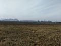
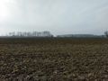
view to the hash (150 m to go)
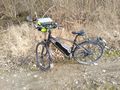
bull
proof
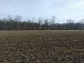
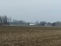
view back to the bull (very small in the middle)
and to the other (western) direction
in the north you can already see Biblis
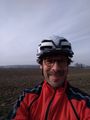
a happy hasher


Achievements
DODO earned the Land geohash achievement
|