Difference between revisions of "2018-04-11 -35 149"
imported>Felix Dance ([live picture]Looking back to Canberra) |
m (More specific location) |
||
| (10 intermediate revisions by 3 users not shown) | |||
| Line 1: | Line 1: | ||
| − | |||
| − | |||
| − | |||
| − | |||
| − | |||
| − | |||
| − | |||
| − | |||
| − | |||
| − | |||
{{meetup graticule | {{meetup graticule | ||
| lat=-35 | | lat=-35 | ||
| Line 19: | Line 9: | ||
== Location == | == Location == | ||
| − | + | Just across the NSW border near Hume, ACT | |
== Participants == | == Participants == | ||
| − | + | *[[User:Felix Dance|Felix Dance]] | |
| − | -- | + | |
| + | == Expedition == | ||
| + | *Made it! -- [[User:Felix Dance|Felix Dance]] ([[User talk:Felix Dance|talk]]) [http://www.openstreetmap.org/?lat=-35.40071680&lon=149.16536520&zoom=16&layers=B000FTF @-35.4007,149.1654] 19:56, 11 April 2018 (GMT+10:00) | ||
| + | |||
| + | I noticed this hash while at work on the construction of the first tram line in Canberra, up in Dickson - the suburb in which I also live. Since I had no plans that evening, and was already thinking of doing a bike ride, I decided to go for it. | ||
| + | |||
| + | Leaving home at just before 7pm I rode 24kms in the dark towards the hash. Half-way there, along the dark shoulder of the Monaro Highway, I noticed my front light was flashing - it was nearly out of batteries. Then I noticed that my rear light was already out. I crept along, using my phone torch as a front light, and kept well clear of the traffic lane. | ||
| − | + | At last I reached the hash region, crossing the border and climbing over a cyclone fence into a construction area to get to the low bushes surrounding the hash. A mob of kangaroos bounced away as I approached. I tried to take a photo of them but it was too dark. The standard 'geohash dance' and I was within a metre. I recorded the location, took some dark photos and headed back to my bike 200m away. | |
| − | |||
| − | + | I went home a slightly different way to minimise dark roads and traffic, and felt safe enough. I got home just before 9pm. I bought a spare pair of lights the next day. | |
| − | |||
== Tracklog == | == Tracklog == | ||
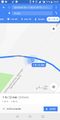
| − | + | [https://goo.gl/maps/DsCqcY7D3452 Here] Is the route I took. | |
== Photos == | == Photos == | ||
| Line 49: | Line 43: | ||
Image:2018-04-11_-35_149_Felix Dance_1523440597533.jpg|Looking back to Canberra | Image:2018-04-11_-35_149_Felix Dance_1523440597533.jpg|Looking back to Canberra | ||
| + | |||
| + | Image:2018-04-11_-35_149_Felix Dance_1523441052866.jpg|On the border | ||
</gallery> | </gallery> | ||
== Achievements == | == Achievements == | ||
| − | + | I was going for the Border Geohash achievement, but I see it only counts for international borders :( | |
| − | |||
| − | + | {{bicycle geohash | |
| − | |||
| − | |||
| − | + | | latitude = -35 | |
| + | | longitude = 149 | ||
| + | | date = 2018-04-11 | ||
| + | | name = [[User:Felix Dance|Felix Dance]] | ||
| + | | distance = 42kms | ||
| + | | bothways = true | ||
| + | | image = 2018-04-11_-35_149_Felix Dance_1523440500763.jpg | ||
| − | + | }} | |
| − | |||
| − | |||
| − | |||
| − | |||
| − | |||
| − | |||
[[Category:Expeditions]] | [[Category:Expeditions]] | ||
| − | + | [[Category:Expeditions with photos]] | |
| − | [[Category:Expeditions with photos]] | ||
| − | |||
| − | |||
| − | |||
| − | |||
| − | |||
[[Category:Coordinates reached]] | [[Category:Coordinates reached]] | ||
| − | + | {{location|AU|NSW|QB}} | |
| − | |||
| − | |||
| − | |||
| − | |||
| − | |||
| − | |||
| − | |||
| − | |||
| − | |||
| − | |||
| − | |||
| − | |||
| − | |||
| − | |||
| − | |||
| − | |||
| − | |||
Latest revision as of 12:54, 1 August 2020
| Wed 11 Apr 2018 in -35,149: -35.4007202, 149.1653596 geohashing.info google osm bing/os kml crox |
Location
Just across the NSW border near Hume, ACT
Participants
Expedition
- Made it! -- Felix Dance (talk) @-35.4007,149.1654 19:56, 11 April 2018 (GMT+10:00)
I noticed this hash while at work on the construction of the first tram line in Canberra, up in Dickson - the suburb in which I also live. Since I had no plans that evening, and was already thinking of doing a bike ride, I decided to go for it.
Leaving home at just before 7pm I rode 24kms in the dark towards the hash. Half-way there, along the dark shoulder of the Monaro Highway, I noticed my front light was flashing - it was nearly out of batteries. Then I noticed that my rear light was already out. I crept along, using my phone torch as a front light, and kept well clear of the traffic lane.
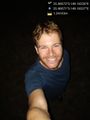
At last I reached the hash region, crossing the border and climbing over a cyclone fence into a construction area to get to the low bushes surrounding the hash. A mob of kangaroos bounced away as I approached. I tried to take a photo of them but it was too dark. The standard 'geohash dance' and I was within a metre. I recorded the location, took some dark photos and headed back to my bike 200m away.
I went home a slightly different way to minimise dark roads and traffic, and felt safe enough. I got home just before 9pm. I bought a spare pair of lights the next day.
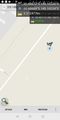
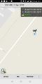
Tracklog
Here Is the route I took.
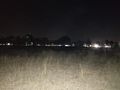
Photos
Geohash success! @-35.4007,149.1653
We at the hash @-35.4007,149.1654
Hast proof
Industrial plant in the ACT
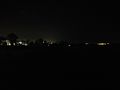
Looking back to Canberra
On the border


Achievements
I was going for the Border Geohash achievement, but I see it only counts for international borders :(
Felix Dance earned the Bicycle geohash achievement
|