Difference between revisions of "2018-04-27 47 -122"
imported>Thomcat ([live picture]Leaving Woodway [http://www.openstreetmap.org/?lat=47.77810640&lon=-122.38279920&zoom=16&layers=B000FTF @47.7781,-122.3828]) |
imported>FippeBot m (Location) |
||
| (2 intermediate revisions by one other user not shown) | |||
| Line 1: | Line 1: | ||
| − | |||
| − | |||
| − | |||
| − | |||
| − | |||
| − | |||
| − | |||
| − | |||
| − | |||
| − | |||
{{meetup graticule | {{meetup graticule | ||
| lat=47 | | lat=47 | ||
| lon=-122 | | lon=-122 | ||
| date=2018-04-27 | | date=2018-04-27 | ||
| + | | graticule_name=Seattle | ||
| + | | graticule_link=Seattle, Washington | ||
}} | }} | ||
| Line 19: | Line 11: | ||
== Location == | == Location == | ||
| − | + | Front lawn of a house in Woodway, WA, in Snohomish county, just north of Seattle. | |
== Participants == | == Participants == | ||
| − | + | * [[User:Thomcat|Thomcat]] | |
| − | |||
== Plans == | == Plans == | ||
| Line 29: | Line 20: | ||
== Expedition == | == Expedition == | ||
| − | + | Dropped off my daughter at the bus stop and figured, what the heck. | |
| + | |||
| + | Umpired a baseball game at Meadowdale the other day, then came down to the Richmond Beach library for a training session. Between the two was the road I was on this morning, leading through Woodway Washington. I'd never been on this particular road, or driven through this little community. Other than a speed limit of 25 MPH throughout, it is pretty nice, and there is a park (Deer Creek) that I'd like to return to with the dog someday. | ||
| + | |||
| + | Anyhow, this visit was to a property on the south end of Woodway, quite close to the "leaving" sign pictured below. Yes, you can guess what is on the other side of that sign. The road had me at 10 meters from the hashpoint, which put it on their porch. Being before 9am and me being not the most presentable, I opted to step onto the lawn and half the distance, then call it good. | ||
| + | |||
| + | To complete the picture review in reverse order, the first picture below is a baseball field south of the hash point that we used to work at a lot. It is quite overgrown and I didn't see any bases anymore - suspect Hillwood Park has been retired. | ||
== Tracklog == | == Tracklog == | ||
| Line 51: | Line 48: | ||
== Achievements == | == Achievements == | ||
{{#vardefine:ribbonwidth|800px}} | {{#vardefine:ribbonwidth|800px}} | ||
| − | + | {{Last man standing | |
| − | + | | latitude = 47 | |
| − | + | | longitude = -122 | |
| − | + | | date = 2018-04-27 | |
| − | + | | gender = man | |
| − | + | | name = Thomcat | |
| − | + | | image = 2018-04-27_47_-122_thomcat_1524844594814.jpg | |
| − | + | }} | |
| − | |||
| − | |||
| − | |||
| − | |||
| − | |||
| − | |||
| − | |||
[[Category:Expeditions]] | [[Category:Expeditions]] | ||
| − | |||
[[Category:Expeditions with photos]] | [[Category:Expeditions with photos]] | ||
| − | |||
| − | |||
| − | |||
| − | |||
| − | |||
[[Category:Coordinates reached]] | [[Category:Coordinates reached]] | ||
| − | + | {{location|US|WA|SN}} | |
| − | |||
| − | |||
| − | |||
| − | |||
| − | |||
| − | |||
| − | |||
| − | |||
| − | |||
| − | |||
| − | |||
| − | |||
| − | |||
| − | |||
| − | |||
| − | |||
| − | |||
Latest revision as of 03:34, 16 August 2019
| Fri 27 Apr 2018 in Seattle: 47.7798101, -122.3812259 geohashing.info google osm bing/os kml crox |
Location
Front lawn of a house in Woodway, WA, in Snohomish county, just north of Seattle.
Participants
Plans
Expedition
Dropped off my daughter at the bus stop and figured, what the heck.
Umpired a baseball game at Meadowdale the other day, then came down to the Richmond Beach library for a training session. Between the two was the road I was on this morning, leading through Woodway Washington. I'd never been on this particular road, or driven through this little community. Other than a speed limit of 25 MPH throughout, it is pretty nice, and there is a park (Deer Creek) that I'd like to return to with the dog someday.
Anyhow, this visit was to a property on the south end of Woodway, quite close to the "leaving" sign pictured below. Yes, you can guess what is on the other side of that sign. The road had me at 10 meters from the hashpoint, which put it on their porch. Being before 9am and me being not the most presentable, I opted to step onto the lawn and half the distance, then call it good.
To complete the picture review in reverse order, the first picture below is a baseball field south of the hash point that we used to work at a lot. It is quite overgrown and I didn't see any bases anymore - suspect Hillwood Park has been retired.
Tracklog
Photos
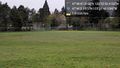
Hillwood park & playfield @47.7676,-122.3634

Geohasher @47.7798,-122.3812
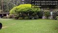
Location @47.7798,-122.3812
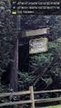
Leaving Woodway @47.7781,-122.3828


Achievements
Thomcat earned the Last man standing achievement
|