Difference between revisions of "2018-05-10 43 -79"
From Geohashing
imported>Frogman ([live picture]Me at the hashpoint.) |
m (More specific location) |
||
| (5 intermediate revisions by 2 users not shown) | |||
| Line 1: | Line 1: | ||
| − | |||
| − | |||
| − | |||
| − | |||
| − | |||
| − | |||
| − | |||
| − | |||
| − | |||
| − | |||
{{meetup graticule | {{meetup graticule | ||
| lat=43 | | lat=43 | ||
| Line 15: | Line 5: | ||
}} | }} | ||
| − | |||
__NOTOC__ | __NOTOC__ | ||
== Location == | == Location == | ||
| − | + | On a quiet residential street in north Etobicoke. | |
== Participants == | == Participants == | ||
| − | + | *[[User:Frogman|Frogman]] | |
| − | |||
| − | == | + | == Expedition == |
| − | + | This one looked way out of the way, but I decided to go for it anyway. Boy was I right: I probably spent about 4 hours on public transit for this one. I took Line 1 to Wilson station, and then bus 96 Wilson on a hot, crowded, slow bus. After spending a minute or so at the hashpoint, I took the 45 Kipling down to Kipling station, and then Line 2 all the way over to Scarborough. | |
| − | + | My hobby is stupid. I like it though. | |
| − | |||
| − | |||
| − | |||
== Photos == | == Photos == | ||
| Line 43: | Line 28: | ||
Image:2018-05-10_43_-79_frogman_1526000929005.jpg|Me at the hashpoint. | Image:2018-05-10_43_-79_frogman_1526000929005.jpg|Me at the hashpoint. | ||
| + | |||
| + | Image:2018-05-10_43_-79_frogman_1526000936917.jpg|Proof. | ||
| + | |||
| + | Image:2018-05-10_43_-79_frogman_1526000955175.jpg|South from the hashpoint. | ||
| + | |||
| + | Image:2018-05-10_43_-79_frogman_1526000975538.jpg|The hashpoint is in the middle of the road here. | ||
</gallery> | </gallery> | ||
== Achievements == | == Achievements == | ||
{{#vardefine:ribbonwidth|800px}} | {{#vardefine:ribbonwidth|800px}} | ||
| − | |||
| − | + | {{Public transport geohash | |
| − | |||
| − | |||
| − | + | | latitude = 43 | |
| + | | longitude = -79 | ||
| + | | date = 2018-05-10 | ||
| + | | busline = the TTC | ||
| + | | name = [[User:Frogman|Frogman]] | ||
| + | | image = 2018-05-10_43_-79_frogman_1526000909299.jpg | ||
| − | + | }} | |
| − | |||
| − | |||
| − | |||
| − | |||
| − | |||
| − | |||
[[Category:Expeditions]] | [[Category:Expeditions]] | ||
| − | |||
[[Category:Expeditions with photos]] | [[Category:Expeditions with photos]] | ||
| − | |||
| − | |||
| − | |||
| − | |||
| − | |||
[[Category:Coordinates reached]] | [[Category:Coordinates reached]] | ||
| − | + | {{location|CA|ON|TO}} | |
| − | |||
| − | |||
| − | |||
| − | |||
| − | |||
| − | |||
| − | |||
| − | |||
| − | |||
| − | |||
| − | |||
| − | |||
| − | |||
| − | |||
| − | |||
| − | |||
| − | |||
Latest revision as of 00:16, 10 August 2020
| Thu 10 May 2018 in 43,-79: 43.7304395, -79.5713012 geohashing.info google osm bing/os kml crox |
Location
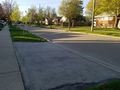
On a quiet residential street in north Etobicoke.
Participants
Expedition
This one looked way out of the way, but I decided to go for it anyway. Boy was I right: I probably spent about 4 hours on public transit for this one. I took Line 1 to Wilson station, and then bus 96 Wilson on a hot, crowded, slow bus. After spending a minute or so at the hashpoint, I took the 45 Kipling down to Kipling station, and then Line 2 all the way over to Scarborough.
My hobby is stupid. I like it though.
Photos
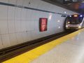
Queens Park subway station.
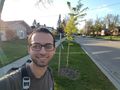
Me at the hashpoint.
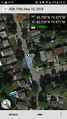
Proof.
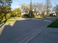
South from the hashpoint.
The hashpoint is in the middle of the road here.


Achievements
Frogman earned the Public transport geohash achievement
|