Difference between revisions of "2018-05-12 41 -71"
imported>Vbob (→Plans) |
imported>FippeBot m (Location) |
||
| (6 intermediate revisions by 2 users not shown) | |||
| Line 31: | Line 31: | ||
<!-- what were the original plans --> | <!-- what were the original plans --> | ||
| − | If it had been forecast to be a nicer day, I would have rounded up a posse of dragee-alongers, fellow-travelers or just plain friends; and figured out a Tron route from home to There and Back Again.... | + | If it had been forecast to be a nicer day, I would have rounded up a posse of dragee-alongers, fellow-travelers or just plain friends; and figured out a Tron route via bicycle all the way from home to There and Back Again.... |
But the Weather Underground claimed long hard rain, so I made no plans. | But the Weather Underground claimed long hard rain, so I made no plans. | ||
| Line 39: | Line 39: | ||
== Expedition == | == Expedition == | ||
<!-- how it all turned out. your narrative goes here. --> | <!-- how it all turned out. your narrative goes here. --> | ||
| + | |||
| + | As it happens, 'clearing up' actually means 'raining less hard until you get so far from dry socks that you might as well continue'. | ||
| + | So, I took my trusty Pegasus for a 15 mile bike wash along paved and nicely maintained old railroad roadbed, including a nice bit of lattice-truss bridgework midway. | ||
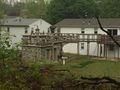
| + | As railroads were wont to do, the path traversed a mix of residential backyards, woods, swamps, and industrial areas - not quite sure which describes the crenellated masonry deck with cranes on the back of a split-level ranch house.... | ||
| + | The hash point itself was halfway up a brushy bank off the paved path - considering the general dampness & poison ivy, getting within 20' seemed close enough. Continued west along the trail a bit to a fascinating trestle over a soap factory - and killed my battery taking a panoramic photo. | ||
| + | Headed back towards dry socks and a second shift gig at the RISD Film Show. Moments after my phone battery died, about 80 'incidental hashers' came along. They would have all passed within spitting distance of the hashpoint about 5 pm.... | ||
| + | http://www.muddyangels.com/rides/east-coast/ | ||
== Tracklog == | == Tracklog == | ||
| Line 48: | Line 55: | ||
--> | --> | ||
<gallery perrow="5"> | <gallery perrow="5"> | ||
| + | image:2018-05-12_41_-71 trestle.jpg | this will have to pass for the Grin™ | ||
| + | image:2018-05-12_41_-71 a-mans-porch-is-his-castle.jpg | enroute "a man's porch is his castle" | ||
| + | image:2018-05-12_41_-71 close-enough..jpg | close enough? | ||
| + | image:2018-05-12_41_-71 hash.s.jpg | wet chalk works really well! | ||
| + | image:2018-05-12_41_-71 soap-works-panorama.s.jpg | soap factory from bridge over the works | ||
| + | |||
</gallery> | </gallery> | ||
| Line 54: | Line 67: | ||
<!-- Add any achievement ribbons you earned below, or remove this section --> | <!-- Add any achievement ribbons you earned below, or remove this section --> | ||
| − | |||
| − | |||
| − | |||
| − | |||
| − | |||
| − | |||
| − | |||
| − | |||
| − | |||
| − | |||
| − | |||
| − | |||
| − | |||
| − | |||
[[Category:Expeditions]] | [[Category:Expeditions]] | ||
| − | |||
[[Category:Expeditions with photos]] | [[Category:Expeditions with photos]] | ||
| − | |||
| − | |||
| − | |||
| − | |||
| − | |||
[[Category:Coordinates reached]] | [[Category:Coordinates reached]] | ||
| − | + | {{location|US|RI|KE}} | |
| − | |||
| − | |||
| − | |||
| − | |||
| − | |||
| − | |||
| − | |||
| − | |||
| − | |||
| − | |||
| − | |||
| − | |||
| − | |||
| − | |||
| − | |||
| − | |||
| − | |||
Latest revision as of 18:41, 26 July 2019
| Sat 12 May 2018 in 41,-71: 41.7126614, -71.5034457 geohashing.info google osm bing/os kml crox |
Location
Looks like this one is just a few feet off the pavement on the north side of Washington Secondary bike path in West Warwick, RI, USA.
Participants
Plans
If it had been forecast to be a nicer day, I would have rounded up a posse of dragee-alongers, fellow-travelers or just plain friends; and figured out a Tron route via bicycle all the way from home to There and Back Again....
But the Weather Underground claimed long hard rain, so I made no plans.
Now it's clearing up, and so's my attitude, so I think I'll excavate my bike from winter storage, and cheat it with my truck to a bit closer put-in point, and try to be at X marks the KCD spot at 4pm this drizzly Saturday.... never have managed a meet-up yet, and this is a long shot, but you can't ask for a much more appropriate hashspot.
Expedition
As it happens, 'clearing up' actually means 'raining less hard until you get so far from dry socks that you might as well continue'. So, I took my trusty Pegasus for a 15 mile bike wash along paved and nicely maintained old railroad roadbed, including a nice bit of lattice-truss bridgework midway. As railroads were wont to do, the path traversed a mix of residential backyards, woods, swamps, and industrial areas - not quite sure which describes the crenellated masonry deck with cranes on the back of a split-level ranch house.... The hash point itself was halfway up a brushy bank off the paved path - considering the general dampness & poison ivy, getting within 20' seemed close enough. Continued west along the trail a bit to a fascinating trestle over a soap factory - and killed my battery taking a panoramic photo. Headed back towards dry socks and a second shift gig at the RISD Film Show. Moments after my phone battery died, about 80 'incidental hashers' came along. They would have all passed within spitting distance of the hashpoint about 5 pm.... http://www.muddyangels.com/rides/east-coast/
Tracklog
Photos

this will have to pass for the Grin™
enroute "a man's porch is his castle"
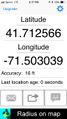
close enough?
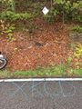
wet chalk works really well!
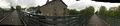
soap factory from bridge over the works


