Difference between revisions of "2018-06-12 53 10"
imported>Leidenfrost |
Leidenfrost (talk | contribs) m (→Photos) |
||
| (13 intermediate revisions by 6 users not shown) | |||
| Line 19: | Line 19: | ||
== Location == | == Location == | ||
| − | |||
On the very edge of a forest near Tangstedt in Schleswig-Holstein, Germany. There is really nothing around for kilometers other than a few houses and fields. | On the very edge of a forest near Tangstedt in Schleswig-Holstein, Germany. There is really nothing around for kilometers other than a few houses and fields. | ||
== Participants == | == Participants == | ||
| − | + | [[User:Leidenfrost|Leidenfrost]] ([[User talk:Leidenfrost|talk]]) and [[User:π π π|π π π]] ([[User talk:π π π|talk]]), first real expedition for both | |
| − | |||
== Plans == | == Plans == | ||
| + | === Leidenfrost === | ||
We planned on visiting this Geohash after attending University that day, by taking our bikes along and biking a certain way home. | We planned on visiting this Geohash after attending University that day, by taking our bikes along and biking a certain way home. | ||
== Expedition == | == Expedition == | ||
| + | |||
| + | === Leidenfrost === | ||
This is also exactly how it went. After nervously watching the recent Geohashes since about three weeks now, we finally found one which we could reasonably achieve. So we set out for this illustrious point after attending Uni for two lectures, in which time seemed to stand still, to afterwards rush to our bikes and speed to the train, which was, to our dismay, but not to our surprise, filled to the brim with commuters. After finally extracting ourselves from the huddle of people, we found ourselves at our final stop. As it was getting dark and cold, much to my personal dislike, as I only put on a T-Shirt in the morning, we hurriedly biked a dozen kilometers or so to our destination. During the ride, it, at multiple times, seemed to start to rain, only to cease before anything could develop. We miraculously both survived the trip dry and were finally at the conceptualized place we both had set out to arrive at. We got our our bikes, went into the nearby barren field, and only had to walk a score to arrive. The Hash was just at the edge of the nearby forest, which almost invited us to step over its boundary and claim the Geohash, which we promptly did. We played a bit around with the coordinates until we were both content with them, officially claimed it at around 19:45, took a few photos, lay an “xkcd” on the ground with sticks and off we went. We only rode a few kilometers home and we both arrived before nightfall. | This is also exactly how it went. After nervously watching the recent Geohashes since about three weeks now, we finally found one which we could reasonably achieve. So we set out for this illustrious point after attending Uni for two lectures, in which time seemed to stand still, to afterwards rush to our bikes and speed to the train, which was, to our dismay, but not to our surprise, filled to the brim with commuters. After finally extracting ourselves from the huddle of people, we found ourselves at our final stop. As it was getting dark and cold, much to my personal dislike, as I only put on a T-Shirt in the morning, we hurriedly biked a dozen kilometers or so to our destination. During the ride, it, at multiple times, seemed to start to rain, only to cease before anything could develop. We miraculously both survived the trip dry and were finally at the conceptualized place we both had set out to arrive at. We got our our bikes, went into the nearby barren field, and only had to walk a score to arrive. The Hash was just at the edge of the nearby forest, which almost invited us to step over its boundary and claim the Geohash, which we promptly did. We played a bit around with the coordinates until we were both content with them, officially claimed it at around 19:45, took a few photos, lay an “xkcd” on the ground with sticks and off we went. We only rode a few kilometers home and we both arrived before nightfall. | ||
| + | |||
| + | === π π π (log from April 2020) === | ||
| + | I rediscovered Geohashing in May and pitched the idea to Leidenfrost, we agreed to try it at the next good opportunity – this was the first reachable one. So we brought our bikes to university and afterwards took the train to Ochsenzoll, from where we cycled about 12 km to the hashpoint. It was located less than 40 m from the street at the edge of a forest. We tried to get the right coordinates as best as possible, took photos and laid "xkcd" on the ground. Then we both rode to our respective homes, which for me was around 15 km. Successful first expedition! I was hooked. | ||
== Photos == | == Photos == | ||
| − | |||
| − | |||
| − | |||
| − | |||
<gallery perrow="5"> | <gallery perrow="5"> | ||
| + | Image:2018-06-12 53 10 1.png | proof | ||
| + | Image:2018-06-12 53 10 2 edit.jpg | Bicycle Geohash | ||
| + | Image:2018-06-12 53 10 4.jpg | DFTBA | ||
| + | Image:2018-06-12 53 10 5 edit.jpg | both of us | ||
| + | Image:2018-06-12 53 10 6.jpg | π π π | ||
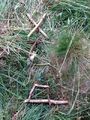
| + | Image:2018-06-12 53 10 7.jpg | the hash | ||
| + | Image:2018-06-12 53 10 9.jpg | Pano 1 | ||
| + | Image:2018-06-12 53 10 10.jpg | Pano 2 | ||
| + | Image:2018-06-12 53 10 11.jpg | First Geohash! | ||
| + | Image:2018-06-12 53 10 12.jpg | distance 27 km | ||
| + | Image:2018-06-12 53 10 13.jpg | average speed | ||
</gallery> | </gallery> | ||
== Achievements == | == Achievements == | ||
| − | |||
<!-- Add any achievement ribbons you earned below, or remove this section --> | <!-- Add any achievement ribbons you earned below, or remove this section --> | ||
| + | {{Public transport geohash | ||
| + | | latitude = 53 | ||
| + | | longitude = 10 | ||
| + | | date = 2018-06-12 | ||
| + | | busline = U1 | ||
| + | | name = Leidenfrost and π π π | ||
| + | | image = | ||
| + | }} | ||
| + | {{land geohash | ||
| + | | latitude = 53 | ||
| + | | longitude = 10 | ||
| + | | date = 2018-06-12 | ||
| + | | name = Leidenfrost and π π π | ||
| + | | image = | ||
| + | }} | ||
| + | {{bicycle geohash | ||
| + | | latitude = 53 | ||
| + | | longitude = 10 | ||
| + | | date = 2018-06-12 | ||
| + | | name = Leidenfrost and π π π | ||
| + | | image = | ||
| + | }} | ||
| + | {{Two to the N achievement | ||
| + | | count = 0 | ||
| + | | date = 2018-06-12 | ||
| + | | latitude = 53 | ||
| + | | longitude = 10 | ||
| + | | name = Leidenfrost and π π π | ||
| + | | reached = true | ||
| + | }} | ||
| − | |||
| − | |||
| − | |||
| − | |||
| − | |||
| − | |||
| − | |||
| − | |||
| − | |||
| − | |||
| − | |||
| − | |||
| − | |||
| − | |||
[[Category:Expeditions]] | [[Category:Expeditions]] | ||
| − | |||
| − | |||
| − | |||
| − | |||
| − | |||
| − | |||
| − | |||
[[Category:Coordinates reached]] | [[Category:Coordinates reached]] | ||
| − | + | {{location|DE|SH|OD}} | |
| − | |||
| − | |||
| − | |||
| − | |||
| − | |||
| − | |||
| − | |||
| − | |||
| − | |||
| − | |||
| − | |||
| − | |||
| − | |||
| − | |||
| − | |||
| − | |||
| − | |||
Latest revision as of 13:46, 22 February 2024
| Tue 12 Jun 2018 in 53,10: 53.7484099, 10.1008393 geohashing.info google osm bing/os kml crox |
Location
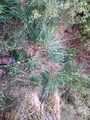
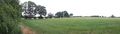
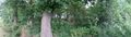
On the very edge of a forest near Tangstedt in Schleswig-Holstein, Germany. There is really nothing around for kilometers other than a few houses and fields.
Participants
Leidenfrost (talk) and π π π (talk), first real expedition for both
Plans
Leidenfrost
We planned on visiting this Geohash after attending University that day, by taking our bikes along and biking a certain way home.
Expedition
Leidenfrost
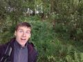
This is also exactly how it went. After nervously watching the recent Geohashes since about three weeks now, we finally found one which we could reasonably achieve. So we set out for this illustrious point after attending Uni for two lectures, in which time seemed to stand still, to afterwards rush to our bikes and speed to the train, which was, to our dismay, but not to our surprise, filled to the brim with commuters. After finally extracting ourselves from the huddle of people, we found ourselves at our final stop. As it was getting dark and cold, much to my personal dislike, as I only put on a T-Shirt in the morning, we hurriedly biked a dozen kilometers or so to our destination. During the ride, it, at multiple times, seemed to start to rain, only to cease before anything could develop. We miraculously both survived the trip dry and were finally at the conceptualized place we both had set out to arrive at. We got our our bikes, went into the nearby barren field, and only had to walk a score to arrive. The Hash was just at the edge of the nearby forest, which almost invited us to step over its boundary and claim the Geohash, which we promptly did. We played a bit around with the coordinates until we were both content with them, officially claimed it at around 19:45, took a few photos, lay an “xkcd” on the ground with sticks and off we went. We only rode a few kilometers home and we both arrived before nightfall.
π π π (log from April 2020)
I rediscovered Geohashing in May and pitched the idea to Leidenfrost, we agreed to try it at the next good opportunity – this was the first reachable one. So we brought our bikes to university and afterwards took the train to Ochsenzoll, from where we cycled about 12 km to the hashpoint. It was located less than 40 m from the street at the edge of a forest. We tried to get the right coordinates as best as possible, took photos and laid "xkcd" on the ground. Then we both rode to our respective homes, which for me was around 15 km. Successful first expedition! I was hooked.
Photos
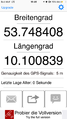
proof
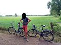
Bicycle Geohash
DFTBA
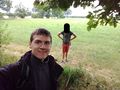
both of us
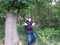
π π π
the hash
Pano 1
Pano 2
First Geohash!
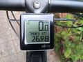
distance 27 km
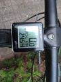
average speed


Achievements
Leidenfrost and π π π earned the Public transport geohash achievement
|
Leidenfrost and π π π earned the Land geohash achievement
|
Leidenfrost and π π π earned the Bicycle geohash achievement
|
