Difference between revisions of "2018-07-05 49 8"
imported>DODO ([live picture]Happy hasher) |
imported>FippeBot m (Location) |
||
| (7 intermediate revisions by one other user not shown) | |||
| Line 20: | Line 20: | ||
== Location == | == Location == | ||
<!-- where you've surveyed the hash to be --> | <!-- where you've surveyed the hash to be --> | ||
| + | A corn field between Römerberg and Schwabenheim. | ||
== Participants == | == Participants == | ||
<!-- who attended: If you link to your wiki user name in this section, your expedition will be picked up by the various statistics generated for geohashing. You may use three tildes ~ as a shortcut to automatically insert the user signature of the account you are editing with. | <!-- who attended: If you link to your wiki user name in this section, your expedition will be picked up by the various statistics generated for geohashing. You may use three tildes ~ as a shortcut to automatically insert the user signature of the account you are editing with. | ||
--> | --> | ||
| + | [[User:DODO|DODO]] | ||
== Plans == | == Plans == | ||
<!-- what were the original plans --> | <!-- what were the original plans --> | ||
| + | To close not to go, but hardly any time today. So I will drive there by car before work. | ||
== Expedition == | == Expedition == | ||
| Line 32: | Line 35: | ||
| − | * | + | *Did it -- [[User:DODO|DODO]] ([[User talk:DODO|talk]]) [http://www.openstreetmap.org/?lat=49.27084050&lon=8.36890200&zoom=16&layers=B000FTF @49.2708,8.3689] 07:55, 5 July 2018 (GMT+02:00) |
| + | |||
| + | Well, just as planned. It was a ten minutes (and 11 kilometer) drive from home. 300 m away from the hash I left the car, walked 500m and had to walk into the field with young corn for maybe 10 meters. Some quick pictures later I found a short cut at the edge of a raspberry field. I promise, I've only stolen one of the tasty fruits. | ||
| + | All in all it took me 10 minutes to walk and another 10 minutes to drive back to my usual way to work. | ||
| + | |||
== Tracklog == | == Tracklog == | ||
<!-- if your GPS device keeps a log, you may post a link here --> | <!-- if your GPS device keeps a log, you may post a link here --> | ||
| + | [https://www.komoot.de/tour/37560837 21 km by car and 1 KM by foot] | ||
== Photos == | == Photos == | ||
| Line 41: | Line 49: | ||
--> | --> | ||
<gallery perrow="5"> | <gallery perrow="5"> | ||
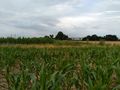
| − | + | Image:2018-07-05_49_8-1.jpg|view to the hash from the car. You can see the raspberry planting on the right | |
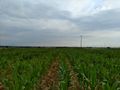
| + | Image:2018-07-05_49_8-2.jpg|15 m into this field | ||
| + | Image:2018-07-05_49_8-7.jpg|proof | ||
Image:2018-07-05_49_8_DODO_1530770235965.jpg|Happy hasher | Image:2018-07-05_49_8_DODO_1530770235965.jpg|Happy hasher | ||
| + | Image:2018-07-05_49_8-3.jpg|view to the south (and the car, the black shadow under the bridge) | ||
| + | Image:2018-07-05_49_8-4.jpg|some field workers in the north | ||
| + | Image:2018-07-05_49_8-5.jpg|better view to the car from the edge of the field | ||
| + | Image:2018-07-05_49_8-6.jpg|raspberry short cut | ||
</gallery> | </gallery> | ||
| Line 48: | Line 62: | ||
{{#vardefine:ribbonwidth|800px}} | {{#vardefine:ribbonwidth|800px}} | ||
<!-- Add any achievement ribbons you earned below, or remove this section --> | <!-- Add any achievement ribbons you earned below, or remove this section --> | ||
| + | {{land geohash | ||
| + | | latitude = 49 | ||
| + | | longitude = 8 | ||
| + | | date = 2018-07-05 | ||
| + | | name = DODO | ||
| + | }} | ||
| − | + | {{Easy_geohash | |
| − | + | | latitude = 49 | |
| − | + | | longitude = 8 | |
| − | + | | date = 2018-07-05 | |
| − | + | | name = DODO | |
| − | + | }} | |
| − | |||
| − | |||
| − | |||
| − | |||
| − | |||
| − | |||
| − | |||
[[Category:Expeditions]] | [[Category:Expeditions]] | ||
| − | |||
[[Category:Expeditions with photos]] | [[Category:Expeditions with photos]] | ||
| − | |||
| − | |||
| − | |||
| − | |||
| − | |||
[[Category:Coordinates reached]] | [[Category:Coordinates reached]] | ||
| − | + | {{location|DE|RP|RP}} | |
| − | |||
| − | |||
| − | |||
| − | |||
| − | |||
| − | |||
| − | |||
| − | |||
| − | |||
| − | |||
| − | |||
| − | |||
| − | |||
| − | |||
| − | |||
| − | |||
| − | |||
Latest revision as of 03:48, 16 August 2019
| Thu 5 Jul 2018 in 49,8: 49.2708461, 8.3689362 geohashing.info google osm bing/os kml crox |
Location
A corn field between Römerberg and Schwabenheim.
Participants
Plans
To close not to go, but hardly any time today. So I will drive there by car before work.
Expedition
- Did it -- DODO (talk) @49.2708,8.3689 07:55, 5 July 2018 (GMT+02:00)
Well, just as planned. It was a ten minutes (and 11 kilometer) drive from home. 300 m away from the hash I left the car, walked 500m and had to walk into the field with young corn for maybe 10 meters. Some quick pictures later I found a short cut at the edge of a raspberry field. I promise, I've only stolen one of the tasty fruits. All in all it took me 10 minutes to walk and another 10 minutes to drive back to my usual way to work.
Tracklog
Photos
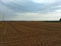
view to the hash from the car. You can see the raspberry planting on the right
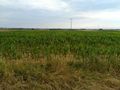
15 m into this field
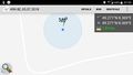
proof
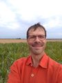
Happy hasher
view to the south (and the car, the black shadow under the bridge)
some field workers in the north
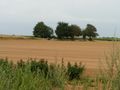
better view to the car from the edge of the field
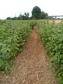
raspberry short cut


Achievements
DODO earned the Land geohash achievement
|
DODO has visited an Easy Geohash
|