Difference between revisions of "2018-07-19 52 9"
From Geohashing
imported>GeorgDerReisende (new report) |
imported>FippeBot m (Location) |
||
| (One intermediate revision by one other user not shown) | |||
| Line 1: | Line 1: | ||
| − | |||
| − | |||
| − | |||
| − | |||
| − | |||
| − | |||
| − | |||
| − | |||
| − | |||
| − | |||
{{meetup graticule | {{meetup graticule | ||
| lat=52 | | lat=52 | ||
| Line 19: | Line 9: | ||
== Location == | == Location == | ||
| − | + | ||
| + | The hash lay on the southern bank of the branch canal to Linden in Seelze. | ||
== Participants == | == Participants == | ||
| − | + | ||
| − | + | [[User:GeorgDerReisende|GeorgDerReisende]] | |
== Plans == | == Plans == | ||
| − | + | ||
| + | A long travel by train to Seelze and walking to the hash. | ||
== Expedition == | == Expedition == | ||
| − | + | ||
| + | I left home at 9:15 and with a bus and three trains I arrived at Seelze at 12:40. And I walked to the hash. I found a dam at the southern side of the canal and on its slope to the canal I found the hash. One meter away from the path and at a tree. Good enough. | ||
== Tracklog == | == Tracklog == | ||
| Line 39: | Line 32: | ||
--> | --> | ||
<gallery perrow="5"> | <gallery perrow="5"> | ||
| + | Image:2018-07-19 52 9 GeorgDerReisende 7287.jpg | proof | ||
| + | Image:2018-07-19 52 9 GeorgDerReisende 7288.jpg | the tree of hash | ||
| + | Image:2018-07-19 52 9 GeorgDerReisende 7289.jpg | the north | ||
| + | Image:2018-07-19 52 9 GeorgDerReisende 7290.jpg | the east | ||
| + | Image:2018-07-19 52 9 GeorgDerReisende 7291.jpg | the south | ||
| + | Image:2018-07-19 52 9 GeorgDerReisende 7292.jpg | the west | ||
| + | Image:2018-07-19 52 9 GeorgDerReisende 7293.jpg | the geohasher | ||
</gallery> | </gallery> | ||
| Line 45: | Line 45: | ||
<!-- Add any achievement ribbons you earned below, or remove this section --> | <!-- Add any achievement ribbons you earned below, or remove this section --> | ||
| − | + | {{Easy_geohash | latitude = 52 | longitude = 9 | date = 2018-07-19 | name = GeorgDerReisende }} | |
| − | |||
| − | |||
| − | + | [[Category:Expeditions]] | |
| − | + | [[Category:Expeditions with photos]] | |
| − | |||
| − | [[Category: | ||
| − | |||
| − | |||
| − | |||
| − | |||
| − | |||
| − | |||
| − | |||
| − | |||
| − | |||
| − | |||
| − | |||
| − | |||
[[Category:Coordinates reached]] | [[Category:Coordinates reached]] | ||
| − | + | {{location|DE|NI|H}} | |
| − | |||
| − | |||
| − | |||
| − | |||
| − | |||
| − | |||
| − | |||
| − | |||
| − | |||
| − | |||
| − | |||
| − | |||
| − | |||
| − | |||
| − | |||
| − | |||
| − | |||
Latest revision as of 03:51, 16 August 2019
| Thu 19 Jul 2018 in 52,9: 52.3925996, 9.5747742 geohashing.info google osm bing/os kml crox |
Location
The hash lay on the southern bank of the branch canal to Linden in Seelze.
Participants
Plans
A long travel by train to Seelze and walking to the hash.
Expedition
I left home at 9:15 and with a bus and three trains I arrived at Seelze at 12:40. And I walked to the hash. I found a dam at the southern side of the canal and on its slope to the canal I found the hash. One meter away from the path and at a tree. Good enough.
Tracklog
Photos
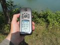
proof
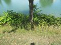
the tree of hash
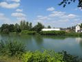
the north
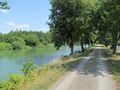
the east
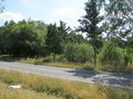
the south
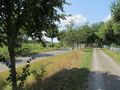
the west

the geohasher


Achievements
GeorgDerReisende has visited an Easy Geohash
|