Difference between revisions of "2018-08-05 52 13"
imported>Coyotebush (An expedition message sent via Geohash Droid for Android.) |
imported>FippeBot m (Location) |
||
| (7 intermediate revisions by one other user not shown) | |||
| Line 1: | Line 1: | ||
| − | |||
| − | |||
| − | |||
| − | |||
| − | |||
| − | |||
| − | |||
| − | |||
| − | |||
{{meetup graticule | {{meetup graticule | ||
| lat=52 | | lat=52 | ||
| Line 20: | Line 11: | ||
== Location == | == Location == | ||
<!-- where you've surveyed the hash to be --> | <!-- where you've surveyed the hash to be --> | ||
| + | In a field near Buch. | ||
== Participants == | == Participants == | ||
<!-- who attended: If you link to your wiki user name in this section, your expedition will be picked up by the various statistics generated for geohashing. You may use three tildes ~ as a shortcut to automatically insert the user signature of the account you are editing with. | <!-- who attended: If you link to your wiki user name in this section, your expedition will be picked up by the various statistics generated for geohashing. You may use three tildes ~ as a shortcut to automatically insert the user signature of the account you are editing with. | ||
--> | --> | ||
| + | * [[User:Coyotebush|Coyotebush]] ([[User talk:Coyotebush|talk]]) | ||
== Plans == | == Plans == | ||
<!-- what were the original plans --> | <!-- what were the original plans --> | ||
| + | I was visiting Berlin for the weekend and had been eyeing this point since Friday. Public transit looked promising. | ||
| + | |||
| + | *Might adventure out to this later in the day -- [[User:Coyotebush|Coyotebush]] ([[User talk:Coyotebush|talk]]) 11:06, 5 August 2018 (GMT+02:00) | ||
== Expedition == | == Expedition == | ||
<!-- how it all turned out. your narrative goes here. --> | <!-- how it all turned out. your narrative goes here. --> | ||
| + | Sunday had refreshingly comfortable weather, and my host was out of town for the day, so I bought a public transit day pass and headed to the center of the city to walk around and see some of the tourist sites: the Reichstag, Brandenburg Gate, Holocaust Memorial, Checkpoint Charlie, and several cathedrals. After all of that, my legs were tired and my phone battery was running low from all of the photography... but the time was only 14:30 and the weather was still nice. | ||
| + | |||
| + | So I headed for the point. Google Maps sent me on the S2 line as far as Blankenburg (currently the last stop due to some sort of track work) and then north on the 150 bus. | ||
| + | |||
| + | *Catching a bus to near the point -- [[User:Coyotebush|Coyotebush]] ([[User talk:Coyotebush|talk]]) [http://www.openstreetmap.org/?lat=52.59111100&lon=13.44171940&zoom=16&layers=B000FTF @52.5911,13.4417] 15:23, 5 August 2018 (GMT+02:00) | ||
| + | |||
| + | In the interest of preserving my battery, I kept the route more or less memorized: get off the bus at Theodor-Brugsch-Straße, walk to its end and jog left to Lindenberger Weg, stop when I reach the power lines. | ||
| + | |||
| + | The final bit of road along the field had no sidewalk so I walked along the edge. I paused and took a photo of the field and power lines... and my phone shut off, as it sometimes does in these situations. I started it up again and focused on finding the precise location. Small plants were growing in the field but it certainly didn't seem closely maintained; meanwhile, the power lines overhead interfered with my GPS signal. Having captured a satisfactory screenshot, I tried taking a couple more photos, but apparently none of them got saved. | ||
| − | + | So, dead phone, and a substantial walk back to known transportation at the Buch station. The bus routes along Lindenberger Weg were infrequent enough to be no help, but the bus stop maps reassured me of what I remembered of the area. Eventually, I found the station, and after a bit more wandering, the place to catch the replacement bus service. That took me back to Pankow-Heinersdorf, and from there I was on the trains again. I headed home to rest and recharge. | |
| − | |||
== Photos == | == Photos == | ||
| Line 39: | Line 43: | ||
--> | --> | ||
<gallery perrow="5"> | <gallery perrow="5"> | ||
| + | |||
| + | Image:2018-08-05_52_13_coyotebush_1533485077024.jpg|Where the sidewalk ends... | ||
| + | |||
| + | Image:2018-08-05_52_13_coyotebush_1533484998147.jpg|Made it, just before my battery died | ||
</gallery> | </gallery> | ||
| Line 45: | Line 53: | ||
<!-- Add any achievement ribbons you earned below, or remove this section --> | <!-- Add any achievement ribbons you earned below, or remove this section --> | ||
| − | + | {{Globetrotter6 | name = coyotebush | northamerica = true | europe = true |continents = 2 }} | |
| − | |||
| − | |||
| − | + | {{Public transport geohash | |
| − | + | | latitude = 52 | |
| − | + | | longitude = 13 | |
| − | + | | date = 2018-08-05 | |
| − | + | | name = coyotebush | |
| + | |||
| + | }} | ||
<!-- If all those plans are never acted upon, change [[Category:Expedition planning]] to [[Category:Not reached - Did not attempt]]. --> | <!-- If all those plans are never acted upon, change [[Category:Expedition planning]] to [[Category:Not reached - Did not attempt]]. --> | ||
| − | |||
[[Category:Expeditions]] | [[Category:Expeditions]] | ||
| − | |||
[[Category:Expeditions with photos]] | [[Category:Expeditions with photos]] | ||
| − | |||
| − | |||
| − | |||
| − | |||
| − | |||
[[Category:Coordinates reached]] | [[Category:Coordinates reached]] | ||
| − | + | {{location|DE|BB|BAR}} | |
| − | |||
| − | |||
| − | |||
| − | |||
| − | |||
| − | |||
| − | |||
| − | |||
| − | |||
| − | |||
| − | |||
| − | |||
| − | |||
| − | |||
| − | |||
| − | |||
| − | |||
Latest revision as of 03:12, 7 August 2019
| Sun 5 Aug 2018 in 52,13: 52.6209120, 13.5142391 geohashing.info google osm bing/os kml crox |
Location
In a field near Buch.
Participants
Plans
I was visiting Berlin for the weekend and had been eyeing this point since Friday. Public transit looked promising.
- Might adventure out to this later in the day -- Coyotebush (talk) 11:06, 5 August 2018 (GMT+02:00)
Expedition
Sunday had refreshingly comfortable weather, and my host was out of town for the day, so I bought a public transit day pass and headed to the center of the city to walk around and see some of the tourist sites: the Reichstag, Brandenburg Gate, Holocaust Memorial, Checkpoint Charlie, and several cathedrals. After all of that, my legs were tired and my phone battery was running low from all of the photography... but the time was only 14:30 and the weather was still nice.
So I headed for the point. Google Maps sent me on the S2 line as far as Blankenburg (currently the last stop due to some sort of track work) and then north on the 150 bus.
- Catching a bus to near the point -- Coyotebush (talk) @52.5911,13.4417 15:23, 5 August 2018 (GMT+02:00)
In the interest of preserving my battery, I kept the route more or less memorized: get off the bus at Theodor-Brugsch-Straße, walk to its end and jog left to Lindenberger Weg, stop when I reach the power lines.
The final bit of road along the field had no sidewalk so I walked along the edge. I paused and took a photo of the field and power lines... and my phone shut off, as it sometimes does in these situations. I started it up again and focused on finding the precise location. Small plants were growing in the field but it certainly didn't seem closely maintained; meanwhile, the power lines overhead interfered with my GPS signal. Having captured a satisfactory screenshot, I tried taking a couple more photos, but apparently none of them got saved.
So, dead phone, and a substantial walk back to known transportation at the Buch station. The bus routes along Lindenberger Weg were infrequent enough to be no help, but the bus stop maps reassured me of what I remembered of the area. Eventually, I found the station, and after a bit more wandering, the place to catch the replacement bus service. That took me back to Pankow-Heinersdorf, and from there I was on the trains again. I headed home to rest and recharge.
Photos
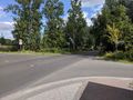
Where the sidewalk ends...
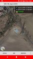
Made it, just before my battery died


Achievements
coyotebush earned the Globetrotter achievement
|
coyotebush earned the Public transport geohash achievement
|