Difference between revisions of "2018-08-11 51 -0"
imported>TheOtterslider (→Participants) |
imported>Saxbophone m (Put Participants in a bullet-point list) |
||
| Line 26: | Line 26: | ||
<!-- who attended: If you link to your wiki user name in this section, your expedition will be picked up by the various statistics generated for geohashing. You may use three tildes ~ as a shortcut to automatically insert the user signature of the account you are editing with. | <!-- who attended: If you link to your wiki user name in this section, your expedition will be picked up by the various statistics generated for geohashing. You may use three tildes ~ as a shortcut to automatically insert the user signature of the account you are editing with. | ||
--> | --> | ||
| − | [[User:Saxbophone|Saxbophone]] ([[User talk:Saxbophone|talk]]) | + | * [[User:Saxbophone|Saxbophone]] ([[User talk:Saxbophone|talk]]) |
| − | [[User:TheOtterslider|TheOtterslider]] ([[User talk:TheOtterslider|talk]]) | + | * [[User:TheOtterslider|TheOtterslider]] ([[User talk:TheOtterslider|talk]]) |
== Plans == | == Plans == | ||
Revision as of 19:52, 11 August 2018
| Sat 11 Aug 2018 in 51,-0: 51.3385797, -0.3616675 geohashing.info google osm bing/os kml crox |
Location
Oxshott Heath, Surrey, England, UK.
This location is Common Land —this means the public can freely roam within it, whether on the path or off, so the hash should definitely be accessible (yipee)!
Participants
Plans
- Saxbophone (talk) plans to get the train out here from London, to arrive at 15:45. Oxshott Railway station is absurdly close to the hash, so 15 minutes should be more than enough time to make the 16:00 Saturday Meetup time.
- TheOtterslider (talk) is also planning to attend. It looks like there's a car park absurdly close
Expedition
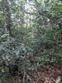
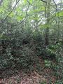
I [TheOtterslider] arrived by car about 10 min before the planned time. I took a wrong turn and missed the car park on the first go round. After parking I headed up a trail in the general direction. Conveniently, there was a trail that took me right by the hash. I walked around it, but decided not to touch the actual location due to a bramble of holly bushes on the location. I waited for Saxbophone till about 5 past 4 then decided to leave. As I was walking down the hill, we met up and went back to the location to take some pictures. We talked for about an hour about things and then split up. However, we missed a perfect opportunity for a PGP key singing. Top Tip: If you are planning a meetup, you should always ask and take advantage of the opportunity.
If you want to see full size images, check out my flickr gallery: https://www.flickr.com/photos/themaxsons/albums/72157670036646417
Tracklog
Photos
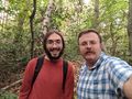
Attendees / Saxbophone (l) and TheOtterslider (r)

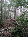
Actual Location
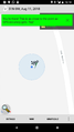
Proof
North
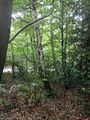
South
East
West


Achievements
This category references all expeditions where photos have been posted on this wiki. Expeditions and Meetups mounted by one or more geohashers, whether successful or not. If an expedition is planned, but not attempted, the page might be listed under Category:Not reached - Did not attempt (yes, the "not reached" is a contradiction in that case).
All expeditions will have a result of Category:Coordinates reached or Category:Coordinates not reached.
Please put retro expeditions into Category:Retro meetup and not into this category.
This user earned the Public transport geohash achievement
|
(Saxbophone)
This user earned the Little Finger Handshake achievement
|
(first meetup for Saxbophone and TheOtterslider to meet a stranger at a GeoHash