Difference between revisions of "2018-08-22 52 -1"
imported>DanQ (→Photos) |
imported>DanQ |
||
| Line 54: | Line 54: | ||
{{#vardefine:ribbonwidth|800px}} | {{#vardefine:ribbonwidth|800px}} | ||
<!-- Add any achievement ribbons you earned below, or remove this section --> | <!-- Add any achievement ribbons you earned below, or remove this section --> | ||
| + | {{Minesweeper geohash | ||
| + | | graticule = Swindon, United Kingdom | ||
| + | | ranknumber = 2 | ||
| + | | n = true | ||
| + | | e = true | ||
| + | | name = Dan Q | ||
| + | }} | ||
<!-- =============== USEFUL CATEGORIES FOLLOW ================ --> | <!-- =============== USEFUL CATEGORIES FOLLOW ================ --> | ||
| − | [[Category: | + | [[Category:Expeditions]] |
| − | |||
| − | |||
| − | |||
| − | |||
| − | |||
[[Category:Expeditions with photos]] | [[Category:Expeditions with photos]] | ||
[[Category:Expeditions with videos]] | [[Category:Expeditions with videos]] | ||
| − | + | ||
| − | |||
| − | |||
| − | |||
[[Category:Coordinates reached]] | [[Category:Coordinates reached]] | ||
| − | |||
| − | |||
| − | |||
| − | |||
| − | |||
| − | |||
| − | |||
| − | |||
| − | |||
| − | |||
| − | |||
| − | |||
| − | |||
| − | |||
| − | |||
| − | |||
| − | |||
| − | |||
Revision as of 19:47, 22 August 2018
| Wed 22 Aug 2018 in 52,-1: 52.0189842, -1.3124316 geohashing.info google osm bing/os kml crox |
Location
Field with public footpath, East Adderbury.
Participants
Plans
I'm keen to get to level 2 of the Minesweeper Geohash achievement, and this far-South-of-graticule hashpoint represents an opportunity to achieve that. I'll be at work during the day, but - energy levels permitting after what'll have been a long day! - I'll find a way to get up here and see if I can get to the hashpoint, aiming to arrive probably around 18:30.
Expedition
SUCCESS! Details to follow, but the short of it is: beautiful village, hash point defended by cows, awarding myself a celebratory egg and chips at the Coach and Horses.
Tracklog
Photos
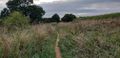
A little overgrown, but I've hiked along far worse

Eventually, I ended up in a field of cows
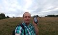
Silly grin as I reach the hashpoint
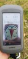
Ground Zero
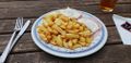
Ham, chips... and TWO eggs...?
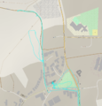
Interesting bit of the track log: the walk around East Adderbury


Achievements
Dan Q achieved level 2 of the Minesweeper Geohash achievement
|