Difference between revisions of "2018-08-31 -37 144"
imported>Felix Dance ([live picture]Geohash panorama) |
m (More specific location) |
||
| (9 intermediate revisions by 3 users not shown) | |||
| Line 15: | Line 15: | ||
}} | }} | ||
| − | |||
| − | |||
== Location == | == Location == | ||
| − | + | In marshy swampland on the Altona coast. | |
== Participants == | == Participants == | ||
| − | + | *[[User:Felix Dance|Felix Dance]] | |
| − | + | ||
| + | == Expedition == | ||
| + | I've been looking out for geohashes each day as I bum my way around at home not being gainfully employed. Most have been sort-of accessible but not very interesting, so I'd been feeling guilty about not going for any. | ||
| + | |||
| + | Not today though! Seeing this hash near the Altona wetlands I jumped on my bike, did some things in the city, then came back the other way via Seddon and Williamstown to get to Altona and hence the hash, stopping only for some potato cakes at a fish and chips place. | ||
| − | + | When I got to the locality, my ride through the Cheetham Wetlands, which is where I was, quickly turned to mud, so I back-tracked and found another way, this one involving ditching my bike and proceeding on foot. Soon I came to a creek, which I washed across sans shoes and socks (still drenched my jeans though). But the path got easier and soon I was walking along a narrow spit of land with metres to go. | |
| − | |||
| − | + | It started raining, but I already had it. The hash was an arm's length out into a pondage, so I captured it, and my surroundings, including a great view of the city skyline and oncoming storm. I am making my way back to the bike as we speak. | |
| − | |||
| − | + | [https://goo.gl/maps/xh1zYvY2cAG2 Here] is the route I took. | |
| − | |||
== Photos == | == Photos == | ||
| Line 47: | Line 46: | ||
Image:2018-08-31_-37_144_Felix Dance_1535688668812.jpg|Geohash panorama | Image:2018-08-31_-37_144_Felix Dance_1535688668812.jpg|Geohash panorama | ||
| + | |||
| + | Image:2018-08-31_-37_144_Felix Dance_1535688693714.jpg|City skyline [http://www.openstreetmap.org/?lat=-37.88453040&lon=144.80534320&zoom=16&layers=B000FTF @-37.8845,144.8053] | ||
| + | |||
| + | Image:2018-08-31_-37_144_Felix Dance_1535688750748.jpg|Wading across a creek [http://www.openstreetmap.org/?lat=-37.88453290&lon=144.80534410&zoom=16&layers=B000FTF @-37.8845,144.8053] | ||
</gallery> | </gallery> | ||
== Achievements == | == Achievements == | ||
| − | {{ | + | {{bicycle geohash |
| − | |||
| − | |||
| − | |||
| − | |||
| − | |||
| − | |||
| − | |||
| − | |||
| − | |||
| − | |||
| − | |||
| − | |||
| − | + | | latitude = -37 | |
| + | | longitude = 144 | ||
| + | | date = 2018-08-31 | ||
| + | | name = [[User:Felix Dance|Felix Dance]] | ||
| + | | distance = 35 kms | ||
| + | | bothways = false | ||
| + | | image = 2018-08-31 -37 144 Felix Dance 1535688617984.jpg | ||
| + | }} | ||
| − | |||
[[Category:Expeditions]] | [[Category:Expeditions]] | ||
| − | |||
[[Category:Expeditions with photos]] | [[Category:Expeditions with photos]] | ||
| − | |||
[[Category:Expedition without GPS]] | [[Category:Expedition without GPS]] | ||
| − | |||
| − | |||
| − | |||
[[Category:Coordinates reached]] | [[Category:Coordinates reached]] | ||
| − | + | {{location|AU|VIC|HB}} | |
| − | |||
| − | |||
| − | |||
| − | |||
| − | |||
| − | |||
| − | |||
| − | |||
| − | |||
| − | |||
| − | |||
| − | |||
| − | |||
| − | |||
| − | |||
| − | |||
| − | |||
Latest revision as of 12:54, 1 August 2020
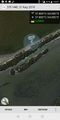
| Fri 31 Aug 2018 in -37,144: -37.8845144, 144.8053193 geohashing.info google osm bing/os kml crox |
Location
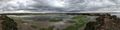
In marshy swampland on the Altona coast.
Participants
Expedition
I've been looking out for geohashes each day as I bum my way around at home not being gainfully employed. Most have been sort-of accessible but not very interesting, so I'd been feeling guilty about not going for any.
Not today though! Seeing this hash near the Altona wetlands I jumped on my bike, did some things in the city, then came back the other way via Seddon and Williamstown to get to Altona and hence the hash, stopping only for some potato cakes at a fish and chips place.
When I got to the locality, my ride through the Cheetham Wetlands, which is where I was, quickly turned to mud, so I back-tracked and found another way, this one involving ditching my bike and proceeding on foot. Soon I came to a creek, which I washed across sans shoes and socks (still drenched my jeans though). But the path got easier and soon I was walking along a narrow spit of land with metres to go.
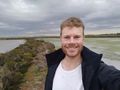
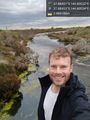
It started raining, but I already had it. The hash was an arm's length out into a pondage, so I captured it, and my surroundings, including a great view of the city skyline and oncoming storm. I am making my way back to the bike as we speak.
Here is the route I took.
Photos
Geohash success!
GPS proof

Geohash marsh
Geohash panorama
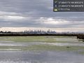
City skyline @-37.8845,144.8053
Wading across a creek @-37.8845,144.8053


Achievements
Felix Dance earned the Bicycle geohash achievement
|