Difference between revisions of "2018-09-07 52 9"
imported>Fippe |
m (Adding hours) |
||
| (4 intermediate revisions by 3 users not shown) | |||
| Line 14: | Line 14: | ||
==Expedition== | ==Expedition== | ||
| − | I took the | + | I took the train to [[wikipedia:Eystrup railway station|Eystrup]]. On the way to the coordinates I walked through Hohenholz and Hämelhausen, eventually arriving near the coordinates on a bridge. I entered the field, recorded proof and walked back to the bridge. |
| − | The bridge was in direct line of sight of the Geohash, and it was home to Geocache [https://coord.info/GC2YKA9 GC2YKA9]. Unfortunately, I was unable to find the Geocache, which is a shame. Geocache [https://coord.info/GC2YMF0 GC2YMF0] was also in line of sight of the Geohash (even though there are a few trees | + | The bridge was in direct line of sight of the Geohash, and it was home to Geocache [https://coord.info/GC2YKA9 GC2YKA9]. Unfortunately, I was unable to find the Geocache, which is a shame. Geocache [https://coord.info/GC2YMF0 GC2YMF0] was also in line of sight of the Geohash (even though there are a few trees in-between), but I was unable to find this one as well. |
It was my first Geohash in the .7,.3 [[centicule]], so I was wearing my 73 t-shirt for the occasion. | It was my first Geohash in the .7,.3 [[centicule]], so I was wearing my 73 t-shirt for the occasion. | ||
| Line 33: | Line 33: | ||
==Achievements== | ==Achievements== | ||
| − | {{#vardefine:ribbonwidth| | + | {{#vardefine:ribbonwidth|100%}} |
{{land geohash|latitude=52|longitude=9|date=2018-09-07|name=[[User:Fippe|Fippe]]|image=2018-09-07 52 09 05 Geohash.jpg}} | {{land geohash|latitude=52|longitude=9|date=2018-09-07|name=[[User:Fippe|Fippe]]|image=2018-09-07 52 09 05 Geohash.jpg}} | ||
{{hashcard|latitude=52|longitude=9|date=2018-09-07|recipient=[[User:Chemluth|Chemluth]]|name=[[User:Fippe|Fippe]]|image=2018-09-14 hashcard front.jpg}} | {{hashcard|latitude=52|longitude=9|date=2018-09-07|recipient=[[User:Chemluth|Chemluth]]|name=[[User:Fippe|Fippe]]|image=2018-09-14 hashcard front.jpg}} | ||
| Line 42: | Line 42: | ||
[[Category:Coordinates reached]] | [[Category:Coordinates reached]] | ||
[[Category:Expeditions with photos]] | [[Category:Expeditions with photos]] | ||
| + | {{location|DE|NI|VER}} | ||
| + | {{user categories|user=Fippe|tram=21|train=143|foot=17|hours=19}} | ||
Latest revision as of 19:10, 11 December 2022
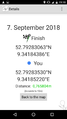
| Fri 7 Sep 2018 in Hannover: 52.7928306, 9.3418439 geohashing.info google osm bing/os kml crox |
Location
This Geohash is located on a harvested field near Donnerhorst.
Participants
Expedition
I took the train to Eystrup. On the way to the coordinates I walked through Hohenholz and Hämelhausen, eventually arriving near the coordinates on a bridge. I entered the field, recorded proof and walked back to the bridge.
The bridge was in direct line of sight of the Geohash, and it was home to Geocache GC2YKA9. Unfortunately, I was unable to find the Geocache, which is a shame. Geocache GC2YMF0 was also in line of sight of the Geohash (even though there are a few trees in-between), but I was unable to find this one as well.
It was my first Geohash in the .7,.3 centicule, so I was wearing my 73 t-shirt for the occasion.
Photos

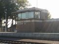
The railway station in Eystrup
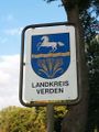
At the district border, Verden's coat of arms
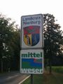
At the district border, Nienburg's coat of arms
Proof
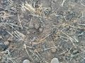
The Geohash
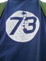
My 73 T-Shirt
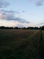
View at the Geohash from the Geocache


Achievements
Fippe earned the Land geohash achievement
|
Fippe earned the Hashcard achievement
|
Fippe earned the Last man standing achievement
|