Difference between revisions of "2018-09-27 51 9"
From Geohashing
imported>GeorgDerReisende m |
imported>FippeBot m (Location) |
||
| (2 intermediate revisions by one other user not shown) | |||
| Line 10: | Line 10: | ||
== Location == | == Location == | ||
| − | The hash lies in the Söhrewald, | + | The hash lies in the Söhrewald, east of Vollmarshausen. |
== Participants == | == Participants == | ||
| Line 21: | Line 21: | ||
== Expedition == | == Expedition == | ||
| − | |||
| − | + | I left home around 13:00 and arrived by bus in Vollmarshausen at 14:00, then I walked into the Söhrewald. 100 meter ahead of the hash, there was a gate across my way, but it was closed only with a wire. The hash lay in a wood of firs. While I danced around I suddenly got a one meter sign without really searching. Easy. | |
| − | |||
== Photos == | == Photos == | ||
| − | |||
| − | |||
| − | |||
<gallery perrow="5"> | <gallery perrow="5"> | ||
| + | Image:2018-09-27 51 9 GeorgDerReisende 4860.jpg | the gate | ||
| + | Image:2018-09-27 51 9 GeorgDerReisende 4862.jpg | the key of the gate | ||
| + | Image:2018-09-27 51 9 GeorgDerReisende 4865.jpg | the hash lies around there | ||
| + | Image:2018-09-27 51 9 GeorgDerReisende 4867.jpg | arrived | ||
| + | Image:2018-09-27 51 9 GeorgDerReisende 4868.jpg | proof | ||
| + | Image:2018-09-27 51 9 GeorgDerReisende 4869.jpg | the north | ||
| + | Image:2018-09-27 51 9 GeorgDerReisende 4870.jpg | the east | ||
| + | Image:2018-09-27 51 9 GeorgDerReisende 4871.jpg | the south | ||
| + | Image:2018-09-27 51 9 GeorgDerReisende 4872.jpg | the west | ||
| + | Image:2018-09-27 51 9 GeorgDerReisende 4873.jpg | the geohasher | ||
</gallery> | </gallery> | ||
| Line 37: | Line 42: | ||
<!-- Add any achievement ribbons you earned below, or remove this section --> | <!-- Add any achievement ribbons you earned below, or remove this section --> | ||
| − | + | {{Easy_geohash | latitude = 51 | longitude = 9 | date = 2018-09-27 | name = GeorgDerReisende }} | |
| − | [[Category: | + | [[Category:Expeditions]] |
| − | + | [[Category:Expeditions with photos]] | |
| − | |||
| − | |||
| − | |||
| − | |||
| − | |||
| − | |||
| − | |||
| − | |||
| − | |||
[[Category:Coordinates reached]] | [[Category:Coordinates reached]] | ||
| − | + | {{location|DE|HE|KS}} | |
| − | |||
| − | |||
| − | |||
| − | |||
| − | |||
| − | |||
| − | |||
| − | |||
| − | |||
| − | |||
| − | |||
| − | |||
| − | |||
| − | |||
| − | |||
| − | |||
| − | |||
Latest revision as of 04:08, 16 August 2019
| Thu 27 Sep 2018 in 51,9: 51.2571506, 9.6052047 geohashing.info google osm bing/os kml crox |
Location
The hash lies in the Söhrewald, east of Vollmarshausen.
Participants
Plans
Walking to the hash.
Expedition
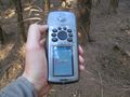
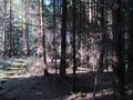
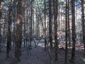
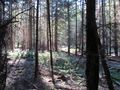
I left home around 13:00 and arrived by bus in Vollmarshausen at 14:00, then I walked into the Söhrewald. 100 meter ahead of the hash, there was a gate across my way, but it was closed only with a wire. The hash lay in a wood of firs. While I danced around I suddenly got a one meter sign without really searching. Easy.
Photos
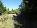
the gate
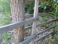
the key of the gate
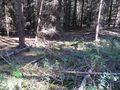
the hash lies around there
arrived
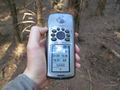
proof
the north
the east
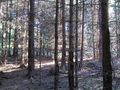
the south
the west
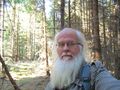
the geohasher


Achievements
GeorgDerReisende has visited an Easy Geohash
|