Difference between revisions of "2018-10-09 51 9"
imported>GeorgDerReisende (new expedition) |
imported>FippeBot m (Location) |
||
| (10 intermediate revisions by 2 users not shown) | |||
| Line 1: | Line 1: | ||
| − | |||
| − | |||
| − | |||
| − | |||
| − | |||
| − | |||
| − | |||
| − | |||
| − | |||
| − | |||
{{meetup graticule | {{meetup graticule | ||
| lat=51 | | lat=51 | ||
| Line 19: | Line 9: | ||
== Location == | == Location == | ||
| − | + | ||
| + | The hash is in the Steinweg in Lohfelden-Vollmarshausen. | ||
== Participants == | == Participants == | ||
| − | + | ||
| − | + | * [[User:GeorgDerReisende|GeorgDerReisende]] | |
| + | * [[User:Digiphono|Digiphono]] and his wife | ||
== Plans == | == Plans == | ||
| − | + | ||
| + | ====GeorgDerReisende==== | ||
| + | |||
| + | Public transport and walking. Arrival around 12 o'clock. | ||
| + | |||
| + | ====Digiphono==== | ||
| + | |||
| + | Driving there by car, take some proof and continue my way. | ||
== Expedition == | == Expedition == | ||
| − | + | ||
| + | ====GeorgDerReisende==== | ||
| + | |||
| + | As Digiphono's first proposed time was around 12 o'clock, I made a plan for the same time with some waiting. So I arrived there at 11:40 and waited there until 12:10 and at a bench some meters down the street some minutes more. The hash lay two meters behind the hedge on the ramp to the house. | ||
| + | |||
| + | ====Digiphono==== | ||
| + | |||
| + | We drove to Kassel, did some shopping at Poco and drove back through Vollmarshausen to catch this 'easy geohash'. We arrived there at around 14:25 pm and, as expected, we could stay in the car, standing directly over the geohash, reaching an accuracy of 2 meters or so... Nothing more, nothing less - just a drive in, with one more hashpoint visited for my statistics hehe. Believe me, those hashes in the middle of a forest make a lot more fun, but still the hash was THE REASON to go to Kassel today... | ||
== Tracklog == | == Tracklog == | ||
| Line 35: | Line 41: | ||
== Photos == | == Photos == | ||
| − | < | + | |
| − | Image: | + | ====GeorgDerReisende==== |
| − | --> | + | |
| − | <gallery | + | <gallery> |
| + | Image:2018-10-09 51 9 GeorgDerReisende 6777.jpg | two meters to the right | ||
| + | Image:2018-10-09 51 9 GeorgDerReisende 6779.jpg | two meters to the left | ||
| + | Image:2018-10-09 51 9 GeorgDerReisende 6780.jpg | proof | ||
| + | Image:2018-10-09 51 9 GeorgDerReisende 6782.jpg | the north | ||
| + | Image:2018-10-09 51 9 GeorgDerReisende 6783.jpg | the east | ||
| + | Image:2018-10-09 51 9 GeorgDerReisende 6784.jpg | the south | ||
| + | Image:2018-10-09 51 9 GeorgDerReisende 6785.jpg | the west | ||
| + | Image:2018-10-09 51 9 GeorgDerReisende 6786.jpg | GeorgDerReisende | ||
| + | </gallery> | ||
| + | |||
| + | ====Digiphono==== | ||
| + | |||
| + | <gallery> | ||
| + | Image:2018-10-09_51_9_001.jpg | Standing at the hash location | ||
| + | Image:2018-10-09_51_9_002.jpg | The hash - proof | ||
| + | Image:2018-10-09_51_9_003.jpg | The hash - screenshot | ||
| + | Image:2018-10-09_51_9_004.jpg | The hash - screenshot | ||
</gallery> | </gallery> | ||
| Line 45: | Line 68: | ||
<!-- Add any achievement ribbons you earned below, or remove this section --> | <!-- Add any achievement ribbons you earned below, or remove this section --> | ||
| − | + | {{Easy_geohash | latitude = 51 | longitude = 9 | date = 2018-10-09 | name = GeorgDerReisende }} | |
| − | |||
| − | |||
| − | + | [[Category:Expeditions]] | |
| − | + | [[Category:Expeditions with photos]] | |
| − | |||
| − | |||
| − | |||
| − | |||
| − | |||
| − | |||
| − | |||
| − | |||
| − | |||
| − | |||
| − | |||
| − | |||
| − | |||
| − | |||
[[Category:Coordinates reached]] | [[Category:Coordinates reached]] | ||
| − | + | {{location|DE|HE|KS}} | |
| − | |||
| − | |||
| − | |||
| − | |||
| − | |||
| − | |||
| − | |||
| − | |||
| − | |||
| − | |||
| − | |||
| − | |||
| − | |||
| − | |||
| − | |||
| − | |||
| − | |||
Latest revision as of 04:11, 16 August 2019
| Tue 9 Oct 2018 in 51,9: 51.2555430, 9.5650296 geohashing.info google osm bing/os kml crox |
Location
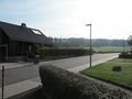
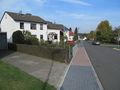
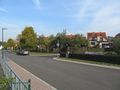
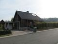
The hash is in the Steinweg in Lohfelden-Vollmarshausen.
Participants
- GeorgDerReisende
- Digiphono and his wife
Plans
GeorgDerReisende
Public transport and walking. Arrival around 12 o'clock.
Digiphono
Driving there by car, take some proof and continue my way.
Expedition
GeorgDerReisende
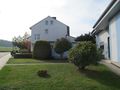
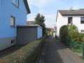
As Digiphono's first proposed time was around 12 o'clock, I made a plan for the same time with some waiting. So I arrived there at 11:40 and waited there until 12:10 and at a bench some meters down the street some minutes more. The hash lay two meters behind the hedge on the ramp to the house.
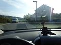
Digiphono
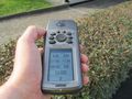
We drove to Kassel, did some shopping at Poco and drove back through Vollmarshausen to catch this 'easy geohash'. We arrived there at around 14:25 pm and, as expected, we could stay in the car, standing directly over the geohash, reaching an accuracy of 2 meters or so... Nothing more, nothing less - just a drive in, with one more hashpoint visited for my statistics hehe. Believe me, those hashes in the middle of a forest make a lot more fun, but still the hash was THE REASON to go to Kassel today...
Tracklog
Photos
GeorgDerReisende
two meters to the right
two meters to the left
proof
the north
the east
the south
the west
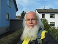
GeorgDerReisende


Digiphono
Standing at the hash location
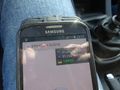
The hash - proof
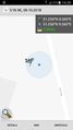
The hash - screenshot
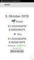
The hash - screenshot


Achievements
GeorgDerReisende has visited an Easy Geohash
|