Difference between revisions of "2018-10-20 50 10"
From Geohashing
imported>GeorgDerReisende (new report) |
imported>FippeBot m (Location) |
||
| (One intermediate revision by one other user not shown) | |||
| Line 1: | Line 1: | ||
| − | |||
| − | |||
| − | |||
| − | |||
| − | |||
| − | |||
| − | |||
| − | |||
| − | |||
| − | |||
{{meetup graticule | {{meetup graticule | ||
| lat=50 | | lat=50 | ||
| Line 19: | Line 9: | ||
== Location == | == Location == | ||
| − | + | ||
| + | The hash lay on a meadow at Schildhof. | ||
== Participants == | == Participants == | ||
| − | + | ||
| − | + | [[User:GeorgDerReisende|GeorgDerReisende]] | |
== Plans == | == Plans == | ||
| − | + | ||
| + | I wanted to travel by train and walking to the hash. | ||
== Expedition == | == Expedition == | ||
| − | |||
| − | + | I left home at 11:30 and with a tram and two trains I arrived at Wildeck-Bosserode. I made a circle in the village and then I walked to Schildhof. I found the hash on a fenced meadow, about five meters behind the fence. Then I waited until hash o'clock for other companions to arrive, but nobody did. Then I walked to Wildeck-Obersuhl, made another circle there and traveled home. | |
| − | |||
== Photos == | == Photos == | ||
| Line 39: | Line 29: | ||
--> | --> | ||
<gallery perrow="5"> | <gallery perrow="5"> | ||
| + | Image:2018-10-20 50 10 GeorgDerReisende 8142.jpg | arriving at Bosserode | ||
| + | Image:2018-10-20 50 10 GeorgDerReisende 8249.jpg | hundred meters and hash | ||
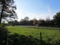
| + | Image:2018-10-20 50 10 GeorgDerReisende 8251.jpg | location of hash | ||
| + | Image:2018-10-20 50 10 GeorgDerReisende 8252.jpg | proof | ||
| + | Image:2018-10-20 50 10 GeorgDerReisende 8253.jpg | five meters to the west | ||
| + | Image:2018-10-20 50 10 GeorgDerReisende 8254.jpg | the north | ||
| + | Image:2018-10-20 50 10 GeorgDerReisende 8256.jpg | the east | ||
| + | Image:2018-10-20 50 10 GeorgDerReisende 8257.jpg | the south | ||
| + | Image:2018-10-20 50 10 GeorgDerReisende 8258.jpg | the geohasher | ||
| + | Image:2018-10-20 50 10 GeorgDerReisende 8266.jpg | at hash o'clock | ||
</gallery> | </gallery> | ||
| Line 45: | Line 45: | ||
<!-- Add any achievement ribbons you earned below, or remove this section --> | <!-- Add any achievement ribbons you earned below, or remove this section --> | ||
| − | + | {{XKCD Centurion | count = 46 | name = GeorgDerReisende }} | |
| − | |||
| − | |||
| − | + | [[Category:Expeditions]] | |
| − | + | [[Category:Expeditions with photos]] | |
| − | |||
| − | [[Category: | ||
| − | |||
| − | |||
| − | |||
| − | |||
| − | |||
| − | |||
| − | |||
| − | |||
| − | |||
| − | |||
| − | |||
| − | |||
[[Category:Coordinates reached]] | [[Category:Coordinates reached]] | ||
| − | + | {{location|DE|HE|HEF}} | |
| − | |||
| − | |||
| − | |||
| − | |||
| − | |||
| − | |||
| − | |||
| − | |||
| − | |||
| − | |||
| − | |||
| − | |||
| − | |||
| − | |||
| − | |||
| − | |||
| − | |||
Latest revision as of 04:13, 16 August 2019
| Sat 20 Oct 2018 in 50,10: 50.9643879, 10.0110673 geohashing.info google osm bing/os kml crox |
Location
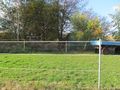
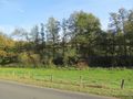
The hash lay on a meadow at Schildhof.
Participants
Plans
I wanted to travel by train and walking to the hash.
Expedition
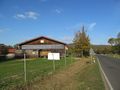
I left home at 11:30 and with a tram and two trains I arrived at Wildeck-Bosserode. I made a circle in the village and then I walked to Schildhof. I found the hash on a fenced meadow, about five meters behind the fence. Then I waited until hash o'clock for other companions to arrive, but nobody did. Then I walked to Wildeck-Obersuhl, made another circle there and traveled home.
Photos
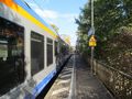
arriving at Bosserode
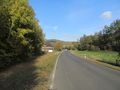
hundred meters and hash
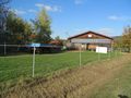
location of hash
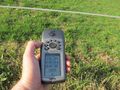
proof
five meters to the west
the north
the east
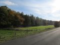
the south
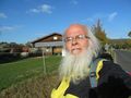
the geohasher
at hash o'clock


Achievements
GeorgDerReisende earned the xkcd Quadraginturion achievement
|