Difference between revisions of "2018-11-03 51 9"
imported>GeorgDerReisende (planning an expedition to Lohfelden-Crumbach) |
imported>FippeBot m (Location) |
||
| (2 intermediate revisions by one other user not shown) | |||
| Line 1: | Line 1: | ||
| − | |||
| − | |||
| − | |||
| − | |||
| − | |||
| − | |||
| − | |||
| − | |||
| − | |||
| − | |||
{{meetup graticule | {{meetup graticule | ||
| lat=51 | | lat=51 | ||
| Line 20: | Line 10: | ||
== Location == | == Location == | ||
| − | The hash | + | The hash lay on a meadow at Lohfelden-Crumbach - between the streets Herchenbachstraße and In der Herchenbach. |
== Participants == | == Participants == | ||
| Line 28: | Line 18: | ||
== Plans == | == Plans == | ||
| − | Public transport and arriving at hash o'clock | + | Public transport and arriving at hash o'clock. |
== Expedition == | == Expedition == | ||
| − | + | ||
| + | I took the bus 37 to Lohfelden. Then I made a walk around the place and came out at a wrong place. I walked around the field and arrived at the site of the hash. The hash lay on the slope between the streets. I took the usual photos and on a bench nearby I waited until hash o'clock for some friends to arrive and to talk with. But nobody arrived. Afterhash I walked to the next bus stop and traveled home. | ||
== Tracklog == | == Tracklog == | ||
| Line 37: | Line 28: | ||
== Photos == | == Photos == | ||
| − | |||
| − | |||
| − | |||
<gallery perrow="5"> | <gallery perrow="5"> | ||
| + | Image:2018-11-03 51 9 GeorgDerReisende 9482.jpg | here I am at the wrong place - the hash lay behind the trees in front of the houses | ||
| + | Image:2018-11-03 51 9 GeorgDerReisende 9491.jpg | the hash on the slope | ||
| + | Image:2018-11-03 51 9 GeorgDerReisende 9494.jpg | proof | ||
| + | Image:2018-11-03 51 9 GeorgDerReisende 9497.jpg | the north | ||
| + | Image:2018-11-03 51 9 GeorgDerReisende 9495.jpg | the east | ||
| + | Image:2018-11-03 51 9 GeorgDerReisende 9498.jpg | the west | ||
| + | Image:2018-11-03 51 9 GeorgDerReisende 9502.jpg | the south | ||
| + | Image:2018-11-03 51 9 GeorgDerReisende 9499.jpg | the geohasher | ||
| + | Image:2018-11-03 51 9 GeorgDerReisende 9503.jpg | better view to the hash | ||
</gallery> | </gallery> | ||
| Line 47: | Line 44: | ||
<!-- Add any achievement ribbons you earned below, or remove this section --> | <!-- Add any achievement ribbons you earned below, or remove this section --> | ||
| − | + | {{XKCD Centurion | count = 47 | name = GeorgDerReisende }} | |
| − | |||
| − | |||
| − | + | [[Category:Expeditions]] | |
| − | + | [[Category:Expeditions with photos]] | |
| − | [[Category: | ||
| − | |||
| − | |||
| − | |||
| − | |||
| − | |||
| − | |||
| − | |||
| − | |||
| − | |||
| − | |||
| − | |||
[[Category:Coordinates reached]] | [[Category:Coordinates reached]] | ||
| − | + | {{location|DE|HE|KS}} | |
| − | |||
| − | |||
| − | |||
| − | |||
| − | |||
| − | |||
| − | |||
| − | |||
| − | |||
| − | |||
| − | |||
| − | |||
| − | |||
| − | |||
| − | |||
| − | |||
| − | |||
Latest revision as of 04:14, 16 August 2019
| Sat 3 Nov 2018 in 51,9: 51.2645585, 9.5462871 geohashing.info google osm bing/os kml crox |
Location
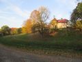
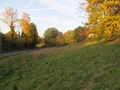
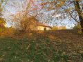
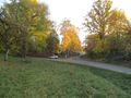
The hash lay on a meadow at Lohfelden-Crumbach - between the streets Herchenbachstraße and In der Herchenbach.
Participants
Plans
Public transport and arriving at hash o'clock.
Expedition
I took the bus 37 to Lohfelden. Then I made a walk around the place and came out at a wrong place. I walked around the field and arrived at the site of the hash. The hash lay on the slope between the streets. I took the usual photos and on a bench nearby I waited until hash o'clock for some friends to arrive and to talk with. But nobody arrived. Afterhash I walked to the next bus stop and traveled home.
Tracklog
Photos

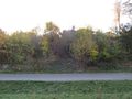
here I am at the wrong place - the hash lay behind the trees in front of the houses
the hash on the slope
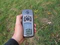
proof
the north
the east
the west
the south
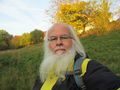
the geohasher
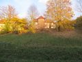
better view to the hash


Achievements
GeorgDerReisende earned the xkcd Quadraginturion achievement
|