Difference between revisions of "2018-11-09 51 -3"
imported>DanQ (→Plans) |
imported>FippeBot m (Location) |
||
| (5 intermediate revisions by one other user not shown) | |||
| Line 1: | Line 1: | ||
| + | {{User:DanQ/Template:DanQBlog | url = https://danq.me/2018/10/16/geohashing-expedition-2018-11-09-51-3/}} | ||
| − | + | [[Image:{{{image|20181109085148DanQ.jpg}}}|thumb|left]] | |
| − | |||
| − | |||
| − | |||
| − | |||
| − | |||
| − | |||
| − | |||
{{meetup graticule | {{meetup graticule | ||
| lat=51 | | lat=51 | ||
| Line 20: | Line 14: | ||
== Location == | == Location == | ||
<!-- where you've surveyed the hash to be --> | <!-- where you've surveyed the hash to be --> | ||
| + | |||
| + | Field near Whitefield Rocks, Langley Marsh. Google Maps says its a nowhere-place but OpenStreetMap suggests there's a footpath right by the hashpoint. | ||
== Participants == | == Participants == | ||
<!-- who attended: If you link to your wiki user name in this section, your expedition will be picked up by the various statistics generated for geohashing. You may use three tildes ~ as a shortcut to automatically insert the user signature of the account you are editing with. | <!-- who attended: If you link to your wiki user name in this section, your expedition will be picked up by the various statistics generated for geohashing. You may use three tildes ~ as a shortcut to automatically insert the user signature of the account you are editing with. | ||
--> | --> | ||
| + | * [[User:DanQ|Dan Q]] | ||
== Plans == | == Plans == | ||
<!-- what were the original plans --> | <!-- what were the original plans --> | ||
| − | Okay, I'm going for it! I'm driving from Oxford to Penzance this morning and having just watched the sun rise over Sedgemoor Services off the M5 I've determined that I'm ahead of schedule by enough that | + | Okay, I'm going for it! I'm driving from Oxford to Penzance this morning and having just watched the sun rise over Sedgemoor Services off the M5 I've determined that I'm ahead of schedule by enough that I can justify a diversion, so I'm going to try for this hashpoint as I "pass". Typing from mobile, apologies for lack of formatting ans any spelling errors; I'll fix them later. - DanQ |
== Expedition == | == Expedition == | ||
| − | |||
| − | + | Driving from Oxford to Penzance in the world's-smallest-rental-car isn't a fun adventure. What is fun, though, is hitting up a graticule I've never hashed in before to see if I can find the day's hashpoint while en-route. | |
| − | + | ||
| + | Parking the awfulmobile in a country lane, I followed the road and then a country footpath towards the hashpoint. I say "footpath", but the public right of way was in dire need of maintenance and the nettles and hedges were encroaching badly upon it. Which was troublesome, because the ''other'' side of the footpath was marked by an electric fence that I didn't want to touch, and so I had to shuffle sideways-at-times through the first field. The second field was easier-going, and I got a great view of the distant storm beginning to roll in which [https://danq.me/2018/11/09/challenge-robin-2/ would soak me later, as I hid adventure-game clues atop a cliff near Penzance]. The third field appeared to be where the hashpoint would be, and it was crossed by the public right of way, but I was surprised to find that the electric fence returned and now barred my way. Luckily its owner had seen fit to put a length of plastic piping around the live wire so it was possible to jump over without burning my crotch, but this seemed a little not-the-done-thing regardless. | ||
| + | |||
| + | The hashpoint was right in the middle of the field and an easy find. Certainly easier than the short-but-exciting hike there and back. | ||
== Photos == | == Photos == | ||
| − | |||
| − | |||
| − | |||
<gallery perrow="5"> | <gallery perrow="5"> | ||
| + | Image:20181109084815DanQ.jpg | The gap between the electric fence and the bushes is allegedly a footpath | ||
| + | Image:20181109084843DanQ.jpg | Nothing but farmland for miles around - the nearest settlement in the distance | ||
| + | Image:20181109085025DanQ.jpg | That looks like a safe concession to your electric fence crossing a right of way | ||
| + | Image:20181109085133DanQ.jpg | Proof | ||
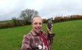
| + | Image:20181109085148DanQ.jpg | The stupidest of grins | ||
</gallery> | </gallery> | ||
| − | == Achievements == | + | <!-- == Achievements == --> |
{{#vardefine:ribbonwidth|800px}} | {{#vardefine:ribbonwidth|800px}} | ||
<!-- Add any achievement ribbons you earned below, or remove this section --> | <!-- Add any achievement ribbons you earned below, or remove this section --> | ||
| − | |||
| − | |||
| − | |||
| − | |||
| − | |||
| − | |||
| − | |||
| − | |||
| − | |||
| − | |||
| − | |||
| − | |||
| − | |||
[[Category:Expeditions]] | [[Category:Expeditions]] | ||
| − | |||
[[Category:Expeditions with photos]] | [[Category:Expeditions with photos]] | ||
| − | |||
| − | |||
| − | |||
| − | |||
| − | |||
[[Category:Coordinates reached]] | [[Category:Coordinates reached]] | ||
| − | + | {{location|GB|ENG|SOM}} | |
| − | |||
| − | |||
| − | |||
| − | |||
| − | |||
| − | |||
| − | |||
| − | |||
| − | |||
| − | |||
| − | |||
| − | |||
| − | |||
| − | |||
| − | |||
| − | |||
| − | |||
Latest revision as of 03:23, 7 August 2019
|
Dan Q also wrote about this expedition on his blog. For more details and higher-resolution pictures, see this expedition's log at https://danq.me/2018/10/16/geohashing-expedition-2018-11-09-51-3/ |

| Fri 9 Nov 2018 in 51,-3: 51.0598525, -3.3150241 geohashing.info google osm bing/os kml crox |
Location
Field near Whitefield Rocks, Langley Marsh. Google Maps says its a nowhere-place but OpenStreetMap suggests there's a footpath right by the hashpoint.
Participants
Plans
Okay, I'm going for it! I'm driving from Oxford to Penzance this morning and having just watched the sun rise over Sedgemoor Services off the M5 I've determined that I'm ahead of schedule by enough that I can justify a diversion, so I'm going to try for this hashpoint as I "pass". Typing from mobile, apologies for lack of formatting ans any spelling errors; I'll fix them later. - DanQ
Expedition
Driving from Oxford to Penzance in the world's-smallest-rental-car isn't a fun adventure. What is fun, though, is hitting up a graticule I've never hashed in before to see if I can find the day's hashpoint while en-route.
Parking the awfulmobile in a country lane, I followed the road and then a country footpath towards the hashpoint. I say "footpath", but the public right of way was in dire need of maintenance and the nettles and hedges were encroaching badly upon it. Which was troublesome, because the other side of the footpath was marked by an electric fence that I didn't want to touch, and so I had to shuffle sideways-at-times through the first field. The second field was easier-going, and I got a great view of the distant storm beginning to roll in which would soak me later, as I hid adventure-game clues atop a cliff near Penzance. The third field appeared to be where the hashpoint would be, and it was crossed by the public right of way, but I was surprised to find that the electric fence returned and now barred my way. Luckily its owner had seen fit to put a length of plastic piping around the live wire so it was possible to jump over without burning my crotch, but this seemed a little not-the-done-thing regardless.
The hashpoint was right in the middle of the field and an easy find. Certainly easier than the short-but-exciting hike there and back.
Photos
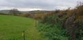
The gap between the electric fence and the bushes is allegedly a footpath
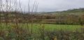
Nothing but farmland for miles around - the nearest settlement in the distance
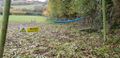
That looks like a safe concession to your electric fence crossing a right of way
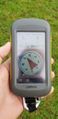
Proof
The stupidest of grins


