Difference between revisions of "2018-12-29 53 -2"
imported>Sourcerer (An expedition message sent via Geohash Droid for Android.) |
imported>FippeBot m (Location) |
||
| (3 intermediate revisions by one other user not shown) | |||
| Line 1: | Line 1: | ||
| − | |||
| − | |||
| − | |||
| − | |||
| − | |||
| − | |||
| − | |||
| − | |||
| − | |||
| − | |||
{{meetup graticule | {{meetup graticule | ||
| lat=53 | | lat=53 | ||
| lon=-2 | | lon=-2 | ||
| date=2018-12-29 | | date=2018-12-29 | ||
| + | | graticule_name=Manchester | ||
| + | | graticule_link=Manchester, United Kingdom | ||
}} | }} | ||
| + | __NOTOC__ | ||
| + | == Location == | ||
| + | |||
| + | Near the perimeter hedge of Congleton Golf Course, Cheshire East, UK. | ||
| − | + | == Planning == | |
| − | |||
| − | + | Visit [[2018-12-29 53 -1|Mansfield]] first and then attempt this one. Return to Mike and Jane's house and spend the rest of the day eating and drinking! | |
| − | |||
== Participants == | == Participants == | ||
| − | |||
| − | |||
| − | + | * [[User:Sourcerer|Sourcerer]] | |
| − | |||
== Expedition == | == Expedition == | ||
| − | |||
| − | + | The journey from 53, -1 to 53, -2 crosses the Derbyshire Peak District. This is an area of outstanding natural beauty and well worth a visit at any time. | |
| − | + | ||
| + | Golf courses are often well fenced and riff raff are kept out. Today there was a narrow gap in the hedge and a squeeze past some fir tree branches led to the forbidden land. The hashpoint was close to the perimeter and I was able to zero onto the hashpoint, take an evidence photo and depart in under one minute. A few golfers were nearby but scarcely had time to register my presence before I'd departed again. | ||
| − | == Photos == | + | == Photos == |
| − | < | + | <gallery caption="Gallery" widths="200px" heights="200px" perrow="3"> |
| − | Image: | + | Image:2018-12-29_53_-2_Sourcerer_1546088956000.jpg | Delayed Proof |
| − | -- | + | Image:2018-12-29 53 -2 Sourcerer.jpg | Google Earth Track |
| − | |||
</gallery> | </gallery> | ||
== Achievements == | == Achievements == | ||
| − | |||
| − | |||
| − | + | {{Sourcerer_links | |
| − | + | | prev = 2018-12-29_53_-1 | |
| − | + | | curr = 2018-12-29_53_-2 | |
| + | | next = 2018-12-30_51_1 | ||
| + | | date = 2018-12-29 | ||
| + | }} | ||
| − | |||
| − | |||
| − | |||
| − | |||
| − | |||
| − | |||
| − | |||
| − | |||
| − | |||
| − | |||
[[Category:Expeditions]] | [[Category:Expeditions]] | ||
| − | |||
[[Category:Expeditions with photos]] | [[Category:Expeditions with photos]] | ||
| − | |||
| − | |||
| − | |||
| − | |||
| − | |||
| − | |||
| − | |||
[[Category:Coordinates reached]] | [[Category:Coordinates reached]] | ||
| − | + | {{location|GB|ENG|CHE}} | |
| − | |||
| − | |||
| − | |||
| − | |||
| − | |||
| − | |||
| − | |||
| − | |||
| − | |||
| − | |||
| − | |||
| − | |||
| − | |||
| − | |||
| − | |||
| − | |||
| − | |||
Latest revision as of 03:28, 7 August 2019
| Sat 29 Dec 2018 in Manchester: 53.1496433, -2.1796691 geohashing.info google osm bing/os kml crox |
Location
Near the perimeter hedge of Congleton Golf Course, Cheshire East, UK.
Planning
Visit Mansfield first and then attempt this one. Return to Mike and Jane's house and spend the rest of the day eating and drinking!
Participants
Expedition
The journey from 53, -1 to 53, -2 crosses the Derbyshire Peak District. This is an area of outstanding natural beauty and well worth a visit at any time.
Golf courses are often well fenced and riff raff are kept out. Today there was a narrow gap in the hedge and a squeeze past some fir tree branches led to the forbidden land. The hashpoint was close to the perimeter and I was able to zero onto the hashpoint, take an evidence photo and depart in under one minute. A few golfers were nearby but scarcely had time to register my presence before I'd departed again.
Photos
- Gallery
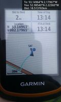
Delayed Proof
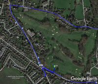
Google Earth Track


Achievements
Expeditions and Plans
| 2018-12-29 | ||
|---|---|---|
| Sheffield, United Kingdom | Sourcerer | A patch of park land in Mansfield, Nottinghamshire, UK. |
| Manchester, United Kingdom | Sourcerer | Near the perimeter hedge of Congleton Golf Course, Cheshire East, UK. |
Sourcerer's Expedition Links
2018-12-29_53_-1 - 2018-12-29_53_-2 - 2018-12-30_51_1 - KML file download of Sourcerer's expeditions for use with Google Earth.