Difference between revisions of "2019-01-11 53 4"
imported>Eupeodes (→Achievements) |
imported>FippeBot m (Location) |
||
| (4 intermediate revisions by one other user not shown) | |||
| Line 33: | Line 33: | ||
== Expedition == | == Expedition == | ||
<!-- how it all turned out. your narrative goes here. --> | <!-- how it all turned out. your narrative goes here. --> | ||
| − | After coming home from work I first had to fix some stuff on my server (the server that also hosts geohashing.info) because I managed to accidentally remove all Lets Encrypt certificates from the machine. | + | After coming home (±400 meters from the hash) from work (±600 meters from the hash)I first had to fix some stuff on my server (the server that also hosts geohashing.info) because I managed to accidentally remove all Lets Encrypt certificates from the machine. |
After that I set out for the hash, I intended for the [[Tron achievement]] so I manually started the exercise on my Fitbit and started walking. Since the ferry from the mainland had just arrived I had to wait a bit at the traffic lights before I got the green light to cross the main road. A minute later or so I decided it was time to get the phone out and set it to navigating to the hash. Since I had done my homework I knew where I needed to be and I could just walk to the hash. After taking a couple of pictures I continued my trip towards home again. I decided to check if the geocache I could see from hash was still there so I took a bit of a detour (still taking care not to cross my own tracks). After the last bit of walking I stopped the exercise on the Fitbit and found that for some reason the gps track was not complete (at all). It did record distance and indicated 1.81 kilometers (which I think is about right with the detour I have to take around the waiting area for the ferry. | After that I set out for the hash, I intended for the [[Tron achievement]] so I manually started the exercise on my Fitbit and started walking. Since the ferry from the mainland had just arrived I had to wait a bit at the traffic lights before I got the green light to cross the main road. A minute later or so I decided it was time to get the phone out and set it to navigating to the hash. Since I had done my homework I knew where I needed to be and I could just walk to the hash. After taking a couple of pictures I continued my trip towards home again. I decided to check if the geocache I could see from hash was still there so I took a bit of a detour (still taking care not to cross my own tracks). After the last bit of walking I stopped the exercise on the Fitbit and found that for some reason the gps track was not complete (at all). It did record distance and indicated 1.81 kilometers (which I think is about right with the detour I have to take around the waiting area for the ferry. | ||
| Line 53: | Line 53: | ||
{{#vardefine:ribbonwidth|800px}} | {{#vardefine:ribbonwidth|800px}} | ||
| + | {{Last man standing | ||
| + | |||
| + | | latitude = 53 | ||
| + | | longitude = 4 | ||
| + | | date = 2019-01-11 | ||
| + | | name = [[User:Eupeodes|Eupeodes]] | ||
| + | | image = 2019-01-11_53_4_grin.jpg | ||
| + | |||
| + | }} | ||
{{cubicle geohash | {{cubicle geohash | ||
| latitude = 53 | | latitude = 53 | ||
| Line 92: | Line 101: | ||
}} | }} | ||
| − | |||
| − | |||
| − | |||
| − | |||
| − | |||
| − | |||
| − | |||
| − | |||
| − | |||
| − | |||
| − | |||
| − | |||
| − | |||
| − | |||
| − | |||
| − | |||
| − | |||
[[Category:Expeditions]] | [[Category:Expeditions]] | ||
| − | |||
[[Category:Expeditions with photos]] | [[Category:Expeditions with photos]] | ||
| − | |||
| − | |||
| − | |||
| − | |||
| − | |||
| − | |||
| − | |||
[[Category:Coordinates reached]] | [[Category:Coordinates reached]] | ||
| − | + | [[Category:Eupeodes]] | |
| − | + | {{location|NL|NH}} | |
| − | |||
| − | |||
| − | |||
| − | |||
| − | |||
| − | |||
| − | |||
| − | |||
| − | |||
| − | |||
| − | [[Category: | ||
| − | |||
| − | |||
| − | |||
| − | |||
| − | |||
Latest revision as of 04:24, 16 August 2019
| Fri 11 Jan 2019 in 53,4: 53.0053883, 4.7784630 geohashing.info google osm bing/os kml crox |
Location
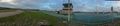
Next to the traffic control tower of Teso (the ferry between Texel and the mainland) on Texel
Participants
- Eupeodes (who lives ~400 meter from the hash point)
Plans
Eupeodes: Go there somewhere during the day. Since I live and work within a kilometer from the hash I can adjust my plans (as far as my work agenda permits) to accommodate meetups
Expedition
After coming home (±400 meters from the hash) from work (±600 meters from the hash)I first had to fix some stuff on my server (the server that also hosts geohashing.info) because I managed to accidentally remove all Lets Encrypt certificates from the machine.
After that I set out for the hash, I intended for the Tron achievement so I manually started the exercise on my Fitbit and started walking. Since the ferry from the mainland had just arrived I had to wait a bit at the traffic lights before I got the green light to cross the main road. A minute later or so I decided it was time to get the phone out and set it to navigating to the hash. Since I had done my homework I knew where I needed to be and I could just walk to the hash. After taking a couple of pictures I continued my trip towards home again. I decided to check if the geocache I could see from hash was still there so I took a bit of a detour (still taking care not to cross my own tracks). After the last bit of walking I stopped the exercise on the Fitbit and found that for some reason the gps track was not complete (at all). It did record distance and indicated 1.81 kilometers (which I think is about right with the detour I have to take around the waiting area for the ferry.
Tracklog
I wanted to add an image of the track of my fitbit, but the recording failed
Photos

The proof

The grin (yes, with a beard)

The more interesting part of the surrounding
The more boring part of the surrounding


Achievements
Eupeodes earned the Last man standing achievement
|
Eupeodes earned the cubicle geohash honorable mention
|

Is it true that Eupeodes earned the tron achievement?
|
Is it true that Eupeodes earned the hash collision achievement?
|
Is it true that Eupeodes earned the Déjà vu geohash achievement?
|