Difference between revisions of "2019-01-18 48 11"
From Geohashing
imported>Claralucia9 (→Participants) |
m (Username changed) |
||
| (4 intermediate revisions by 3 users not shown) | |||
| Line 19: | Line 19: | ||
== Location == | == Location == | ||
| − | + | In the forest south-east of Putzbrunn, south of Munich | |
== Participants == | == Participants == | ||
| − | [[User: | + | [[User:Clearlucid9|Claralucia9]] ([[User talk:Clearlucid9|talk]]) |
== Plans == | == Plans == | ||
| Line 28: | Line 28: | ||
== Expedition == | == Expedition == | ||
| − | + | Friday, leaving work early, snow, sunshine and a hashpoint within reach. What more should I ask for? | |
| + | I took the car to the fringe of the woods and then walked along a forest road and a footpath to very close to the hash. Luckily the trees were not very dense in this area of the forest and the low afternoon sun gave the scene a very pleasant look. I marked the hash with an "X" in the snow and "signed" the "logbook" (see photos). | ||
| + | It's been a nice walk in the sun. | ||
== Tracklog == | == Tracklog == | ||
| Line 54: | Line 56: | ||
<!-- Add any achievement ribbons you earned below, or remove this section --> | <!-- Add any achievement ribbons you earned below, or remove this section --> | ||
| − | |||
| − | |||
| − | |||
| − | |||
| − | |||
| − | |||
| − | |||
| − | |||
| − | |||
| − | |||
| − | |||
| − | |||
[[Category:Expeditions]] | [[Category:Expeditions]] | ||
| − | |||
[[Category:Expeditions with photos]] | [[Category:Expeditions with photos]] | ||
| − | |||
| − | |||
| − | |||
| − | |||
| − | |||
| − | |||
| − | |||
[[Category:Coordinates reached]] | [[Category:Coordinates reached]] | ||
| − | + | {{location|DE|BY|M}} | |
| − | |||
| − | |||
| − | |||
| − | |||
| − | |||
| − | |||
| − | |||
| − | |||
| − | |||
| − | |||
| − | |||
| − | |||
| − | |||
| − | |||
| − | |||
| − | |||
| − | |||
Latest revision as of 12:37, 31 October 2021
| Fri 18 Jan 2019 in 48,11: 48.0570718, 11.7443588 geohashing.info google osm bing/os kml crox |
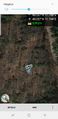
Location
In the forest south-east of Putzbrunn, south of Munich
Participants
Plans
Expedition
Friday, leaving work early, snow, sunshine and a hashpoint within reach. What more should I ask for? I took the car to the fringe of the woods and then walked along a forest road and a footpath to very close to the hash. Luckily the trees were not very dense in this area of the forest and the low afternoon sun gave the scene a very pleasant look. I marked the hash with an "X" in the snow and "signed" the "logbook" (see photos). It's been a nice walk in the sun.
Tracklog
Photos
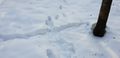
X marks the spot
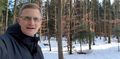
Me at the hashpoint
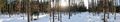
Panorama
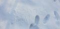
"Log"
As close as you can get...


